GROUND WATER ATLAS of the UNITED STATES
California, Nevada
HA 730-B
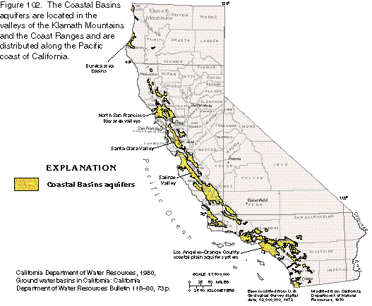
Coastal Basins aquifers
There are two different files for each illustration
- A 72 ppi GIF file, suitable for screen viewing is accessed through
the thumbnail image
- An eps file, suitable for downloading to be printed or edited is accessed
through the "eps file" link. Most files are Adobe Illustrator
5.5, exceptions are noted. These files have been compressed with GNU's gzip
utility. If your web browser defaults to a screen display of the file, turn
on the "Load to local disk" option before downloading. Download
and process these eps files as ascii, not binary.
Introduction
Eureka area basins
Figure 102 Map of Coastal Basins aquifers (20K)
 editable eps
file b102.eps.gz (257K compressed)
editable eps
file b102.eps.gz (257K compressed)
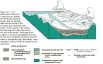
Figure 103 Block diagram of Coastal Basins geology (25K)
 This
illustration contains a placed image. Download the Adobe Illustrator 6 eps
file b103.eps.gz (373K compressed) which contains an imbedded Adobe
Photoshop 3 (eps) file. You may also want to download the editable
Photoshop file b103psh.eps.gz(221K compressed)
This
illustration contains a placed image. Download the Adobe Illustrator 6 eps
file b103.eps.gz (373K compressed) which contains an imbedded Adobe
Photoshop 3 (eps) file. You may also want to download the editable
Photoshop file b103psh.eps.gz(221K compressed)
Figure 104 Map of Eureka area basins (21K)
 editable eps
file b104.eps.gz (452K compressed)
editable eps
file b104.eps.gz (452K compressed)
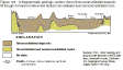
Figure 105 Diagrammatic geologic section, Eureka area (11K)
 editable
eps
file b105.eps.gz (291K compressed)
editable
eps
file b105.eps.gz (291K compressed)
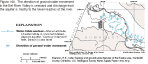
Figure 106 Map of water table contours, Eel River Valley (12K)
 editable
eps
file b106.eps.gz (57K compressed)
editable
eps
file b106.eps.gz (57K compressed)
 This
illustration contains a placed image. Download the Adobe Illustrator 6 eps
file b103.eps.gz (373K compressed) which contains an imbedded Adobe
Photoshop 3 (eps) file. You may also want to download the editable
Photoshop file b103psh.eps.gz(221K compressed)
This
illustration contains a placed image. Download the Adobe Illustrator 6 eps
file b103.eps.gz (373K compressed) which contains an imbedded Adobe
Photoshop 3 (eps) file. You may also want to download the editable
Photoshop file b103psh.eps.gz(221K compressed) 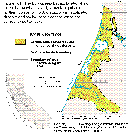 editable eps
file b104.eps.gz (452K compressed)
editable eps
file b104.eps.gz (452K compressed) 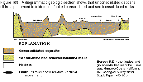 editable
eps
file b105.eps.gz (291K compressed)
editable
eps
file b105.eps.gz (291K compressed)  editable
eps
file b106.eps.gz (57K compressed)
editable
eps
file b106.eps.gz (57K compressed)