GROUND WATER ATLAS of the UNITED STATES
California, Nevada
HA 730-B
Coastal Basins aquifers
There are two different files for each illustration
- A 72 ppi GIF file, suitable for screen viewing is accessed through
the thumbnail image
- An eps file, suitable for downloading to be printed or edited is accessed
through the "eps file" link. Most files are Adobe Illustrator
5.5, exceptions are noted. These files have been compressed with GNU's gzip
utility. If your web browser defaults to a screen display of the file, turn
on the "Load to local disk" option before downloading. Download
and process these eps files as ascii, not binary.
Los Angeles-Orange County coastal plain aquifer system
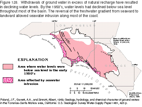
Figure 128 Map of area of ground water below sea level, early 1950s (14K)
 editable eps
file b128.eps.gz (37K compressed)
editable eps
file b128.eps.gz (37K compressed)
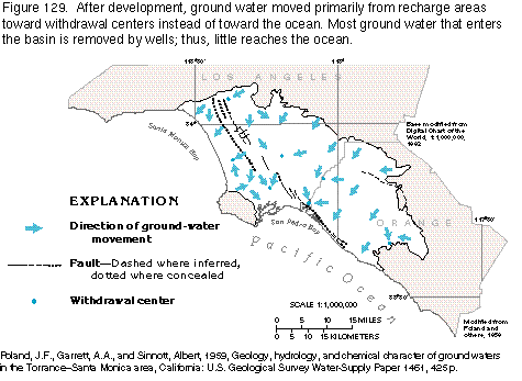
Figure 129 Map of ground-water movement (12K)
 editable eps
file b129.eps.gz (31K compressed)
editable eps
file b129.eps.gz (31K compressed)
Figure 130 Diagrams showing methods of limiting seawater intrusion (24K)
 editable eps
file b130.eps.gz (737K compressed)
editable eps
file b130.eps.gz (737K compressed)
Figure 131 Map of area of ground-water level below sea level, late1980s
(13K)
 editable
eps
file b131.eps.gz (29 Kcompressed)
editable
eps
file b131.eps.gz (29 Kcompressed)
 editable eps
file b129.eps.gz (31K compressed)
editable eps
file b129.eps.gz (31K compressed) 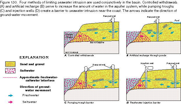 editable eps
file b130.eps.gz (737K compressed)
editable eps
file b130.eps.gz (737K compressed)  editable
eps
file b131.eps.gz (29 Kcompressed)
editable
eps
file b131.eps.gz (29 Kcompressed)