GROUND WATER ATLAS of the UNITED STATES
Arizona, Colorado, New Mexico, Utah
HA 730-C
Colorado Plateaus aquifers
There are two different files for each illustration
- A 90 ppi JPEG file, suitable for screen viewing is accessed
through the thumbnail image.
- A tiff file is accessed through the "tiff file"
link. All files are Adobe Photoshop. These files have been compressed
with GNU's gzip utility. If your web browser defaults to a screen
display of the file, turn on the "Load to local disk"
option before downloading. Download and process these tiff files
as ascii, not binary.
Uinta-Animas Aquifer
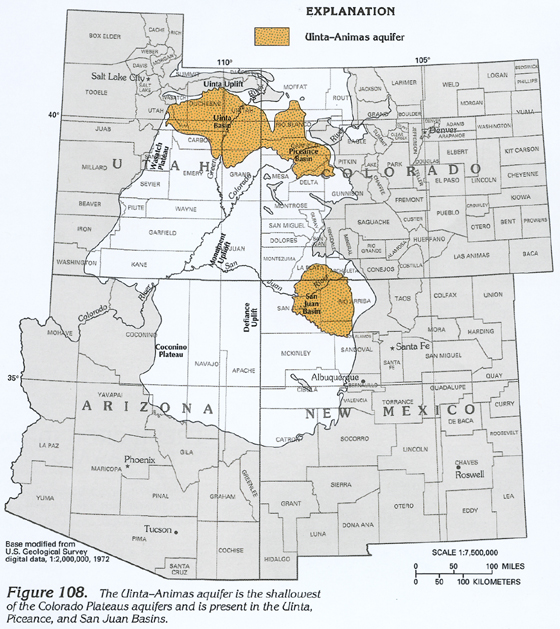
Figure 108 Map showing the location of the Uinta-Animas
aquifer (316K)
 downloadable tiff file C108.tif.gz (2.4MB
compressed)
downloadable tiff file C108.tif.gz (2.4MB
compressed)
Figure 109 Correlation chart showing the
geologic and hydrogeologic characteristics of the Uinta-Animas
aquifer (352K)
 downloadable tiff file C109.tif.gz (2.8MB
compressed)
downloadable tiff file C109.tif.gz (2.8MB
compressed)
Hydrogeologic Units
Figure 110 Cross section showing the hydrogeologic composition
of the central part of the Piceance Basin (192K)
 downloadable tiff file C110.tif.gz (1.4MB
compressed)
downloadable tiff file C110.tif.gz (1.4MB
compressed)
Recharge and Discharge
Water-Level Conditions
Figure 111 Map showing the potentiometric surface of the Uinta-Animas
aquifer in the Uinta Basin (388K)
 downloadable tiff file C111.tif.gz (3.2MB
compressed)
downloadable tiff file C111.tif.gz (3.2MB
compressed)
Figure 112 Map showing the potentiometric surface
of the Uinta-Animas aquifer in the Piceance Basin (304K)
 downloadable tiff file C112.tif.gz (2.5MB
compressed)
downloadable tiff file C112.tif.gz (2.5MB
compressed)
Figure 113 Map showing the potentiometric surface
of the Uinta-Animas aquifer in the San Juan Basin (332K)
 downloadable tiff file C113.tif.gz (3.2MB
compressed)
downloadable tiff file C113.tif.gz (3.2MB
compressed)
Ground-Water Quality
Figure 114 Map showing the concentrations of dissolved solids
in water from the upper part of the Uinta-Animas aquifer in the
Piceance Basin (244K)
 downloadable tiff file C114.tif.gz (2MB
compressed)
downloadable tiff file C114.tif.gz (2MB
compressed)
Figure 115 Map showing the concentrations of dissolved
solids in water from the lower part of the Uinta-Animas aquifer
in the Piceance Basin (256K)
 downloadable tiff file C115.tif.gz (2.3MB
compressed)
downloadable tiff file C115.tif.gz (2.3MB
compressed)
 downloadable tiff file C108.tif.gz (2.4MB
compressed)
downloadable tiff file C108.tif.gz (2.4MB
compressed) 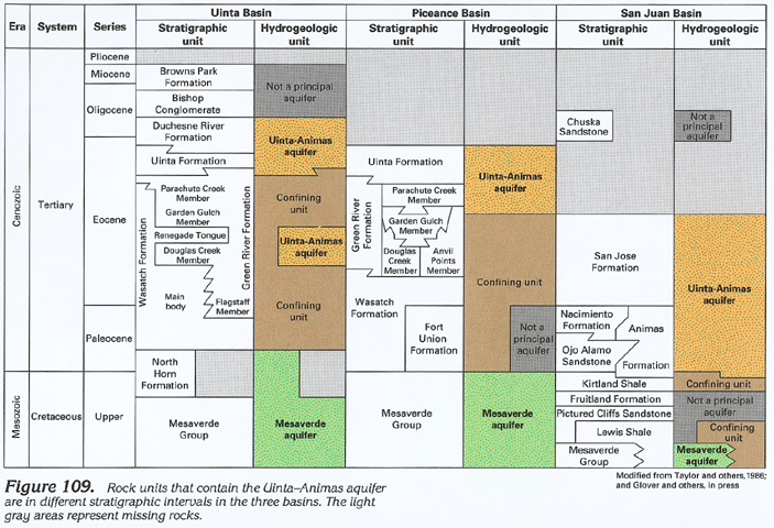 downloadable tiff file C109.tif.gz (2.8MB
compressed)
downloadable tiff file C109.tif.gz (2.8MB
compressed) 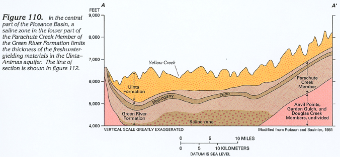 downloadable tiff file C110.tif.gz (1.4MB
compressed)
downloadable tiff file C110.tif.gz (1.4MB
compressed) 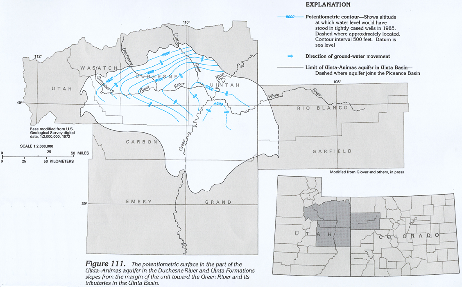 downloadable tiff file C111.tif.gz (3.2MB
compressed)
downloadable tiff file C111.tif.gz (3.2MB
compressed) 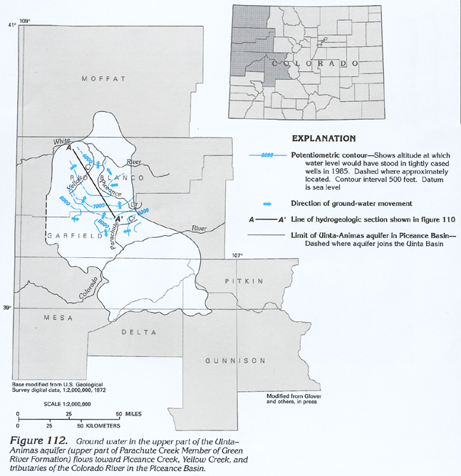 downloadable tiff file C112.tif.gz (2.5MB
compressed)
downloadable tiff file C112.tif.gz (2.5MB
compressed) 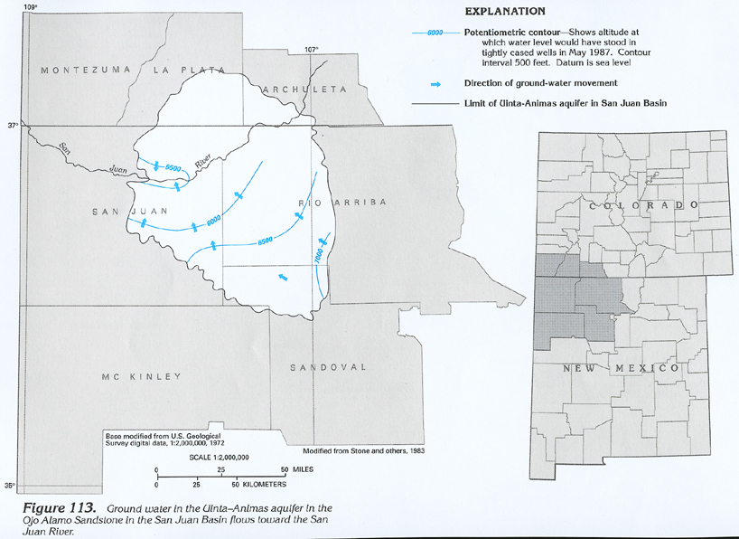 downloadable tiff file C113.tif.gz (3.2MB
compressed)
downloadable tiff file C113.tif.gz (3.2MB
compressed)  downloadable tiff file C114.tif.gz (2MB
compressed)
downloadable tiff file C114.tif.gz (2MB
compressed) 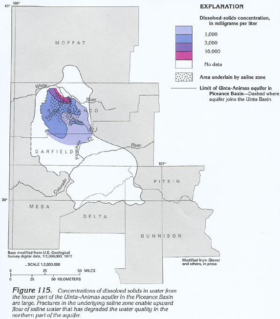 downloadable tiff file C115.tif.gz (2.3MB
compressed)
downloadable tiff file C115.tif.gz (2.3MB
compressed)