GROUND WATER ATLAS of the UNITED STATES
Arizona, Colorado, New Mexico, Utah
HA 730-C
Colorado Plateaus aquifers
There are two different files for each illustration
- A 90 ppi JPEG file, suitable for screen viewing is accessed
through the thumbnail image.
- A tiff file is accessed through the "tiff file"
link. All files are Adobe Photoshop. These files have been compressed
with GNU's gzip utility. If your web browser defaults to a screen
display of the file, turn on the "Load to local disk"
option before downloading. Download and process these tiff files
as ascii, not binary.
Dakota-Glen Canyon Aquifer System
Figure 120 Map showing location of the Dakota-Glen Canyon
aquifer system (368K)
 downloadable tiff file C120.tif.gz (3MB
compressed)
downloadable tiff file C120.tif.gz (3MB
compressed)
Figure 121 Correlation chart showing the
geologic and hydrogeologic characteristics of the Dakota-Glen
Canyon aquifer system (516K)
 downloadable tiff file C121.tif.gz (3.9MB
compressed)
downloadable tiff file C121.tif.gz (3.9MB
compressed)
Table 1 Table showing the lithographic character
and thickness of the aquifers and confining units of the Dakota-Glen
Canyon aquifer system (216K)
 downloadable tiff file Ctab1.tif.gz (1.5MB
compressed)
downloadable tiff file Ctab1.tif.gz (1.5MB
compressed)
Figure 122 Generalized hydrogeologic section
through the Black Mesa Basin showing the relation of the Dakota-Glen
Canyon aquifer system to the overlying and underlying hydrogeologic
units (224K)
 downloadable tiff file C122.tif.gz (1.6MB
compressed)
downloadable tiff file C122.tif.gz (1.6MB
compressed)
Hydrogeologic Units
Figure 123 Map showing depth to the top of the Dakota
aquifer (256K)
 downloadable tiff file C123.tif.gz (2MB
compressed)
downloadable tiff file C123.tif.gz (2MB
compressed)
Figure 124 Photograph showing well-cemented
parts of the Navajo Sandstone at Rainbow Bridge National Monument,
Utah (208K)
 downloadable tiff file C124.tif.gz (1.7MB
compressed)
downloadable tiff file C124.tif.gz (1.7MB
compressed)
Figure 125 Map showing depth to the top
of the Glen Canyon aquifer (292K)
 downloadable tiff file C125.tif.gz (2.2MB
compressed)
downloadable tiff file C125.tif.gz (2.2MB
compressed)
Recharge and Discharge
Figure 126 Map showing the potentiometric contour and
ground-water movement in the Dakota aquifer (268K)
 downloadable tiff file C126.tif.gz (1.9MB
compressed)
downloadable tiff file C126.tif.gz (1.9MB
compressed)
Figure 127 Map showing the potentiometric contour and ground-water
movement in the Glen Canyon aquifer (264K)
 downloadable tiff file C127.tif.gz (1.8MB
compressed)
downloadable tiff file C127.tif.gz (1.8MB
compressed)
Aquifer Characteristics
Ground-Water Quality
Figure 128 Map showing the concentration of dissolved solids
in water from the Glen Canyon aquifer (300K)
 downloadable tiff file C128.tif.gz (2.2MB
compressed)
downloadable tiff file C128.tif.gz (2.2MB
compressed)
 downloadable tiff file C120.tif.gz (3MB
compressed)
downloadable tiff file C120.tif.gz (3MB
compressed) 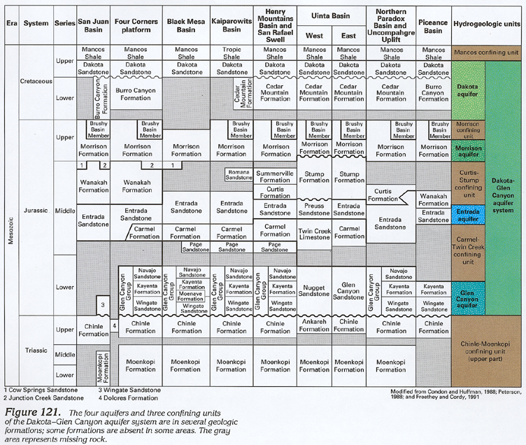 downloadable tiff file C121.tif.gz (3.9MB
compressed)
downloadable tiff file C121.tif.gz (3.9MB
compressed)  downloadable tiff file Ctab1.tif.gz (1.5MB
compressed)
downloadable tiff file Ctab1.tif.gz (1.5MB
compressed) 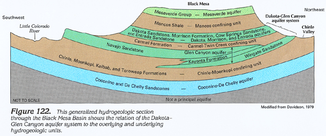 downloadable tiff file C122.tif.gz (1.6MB
compressed)
downloadable tiff file C122.tif.gz (1.6MB
compressed) 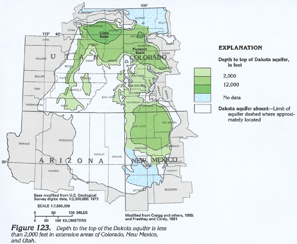 downloadable tiff file C123.tif.gz (2MB
compressed)
downloadable tiff file C123.tif.gz (2MB
compressed) 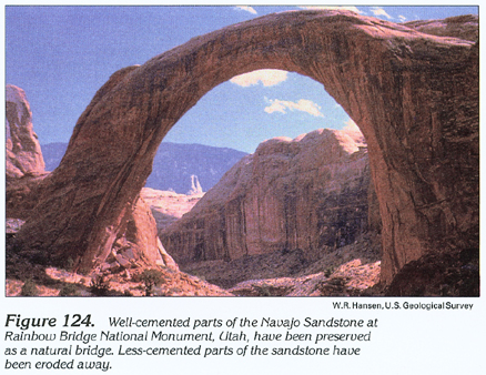 downloadable tiff file C124.tif.gz (1.7MB
compressed)
downloadable tiff file C124.tif.gz (1.7MB
compressed) 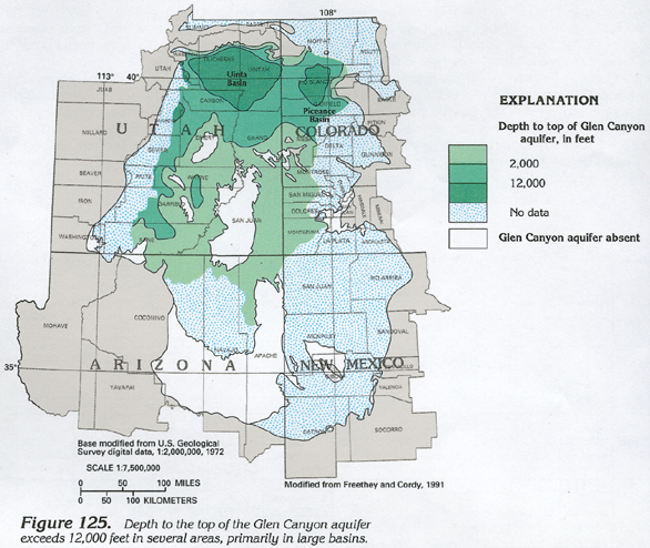 downloadable tiff file C125.tif.gz (2.2MB
compressed)
downloadable tiff file C125.tif.gz (2.2MB
compressed) 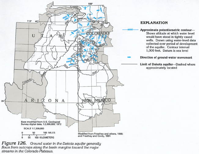 downloadable tiff file C126.tif.gz (1.9MB
compressed)
downloadable tiff file C126.tif.gz (1.9MB
compressed) 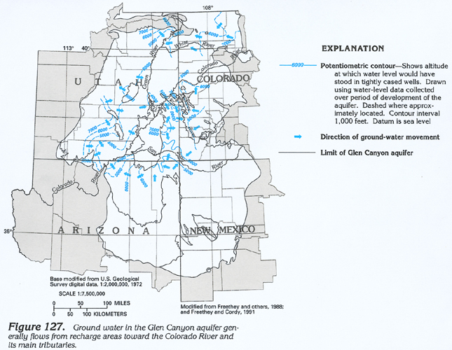 downloadable tiff file C127.tif.gz (1.8MB
compressed)
downloadable tiff file C127.tif.gz (1.8MB
compressed) 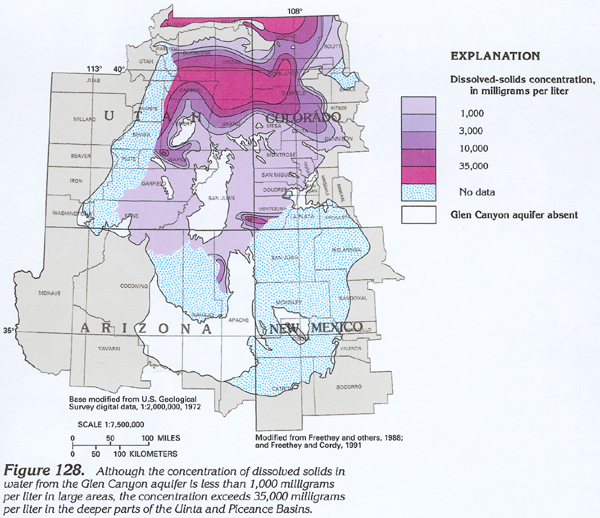 downloadable tiff file C128.tif.gz (2.2MB
compressed)
downloadable tiff file C128.tif.gz (2.2MB
compressed)