GROUND WATER ATLAS of the UNITED STATES
Arizona, Colorado, New Mexico, Utah
HA 730-C
Denver Basin aquifer system
There are two different files for each illustration
- A 90 ppi JPEG file, suitable for screen viewing is accessed
through the thumbnail image.
- A tiff file is accessed through the "tiff file"
link. All files are Adobe Photoshop. These files have been compressed
with GNU's gzip utility. If your web browser defaults to a screen
display of the file, turn on the "Load to local disk"
option before downloading. Download and process these tiff files
as ascii, not binary.
Hydrogeologic Units
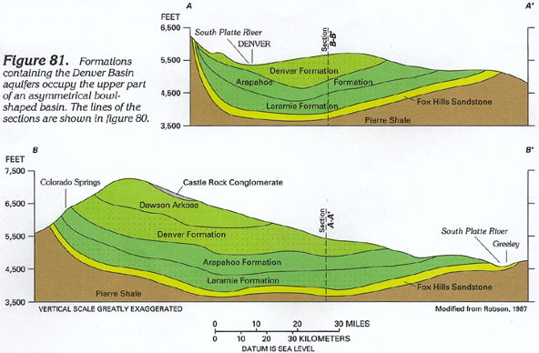
Figure 81 Cross section showing the formations containing
the Denver Basin aquifers (224K)
 downloadable tiff file C081.tif.gz
(1.7MB compressed)
downloadable tiff file C081.tif.gz
(1.7MB compressed)
Figure 82 Photograph showing bedrock formations along the
margin of the Denver Basin west of Denver, Colorado (244K)
 downloadable tiff file C082.tif.gz
(1.9MB compressed)
downloadable tiff file C082.tif.gz
(1.9MB compressed)
Figure 83 Correlation chart summarizing the geologic and
hydrologic characteristics of the Denver Basin aquifers (364K)
 downloadable tiff file C083.tif.gz
(2.7MB compressed)
downloadable tiff file C083.tif.gz
(2.7MB compressed)
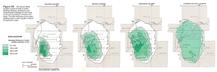
Figure 84 Maps showing the saturated thickness of water-yielding
materials in each of the four Denver Basin aquifers (136K)
 downloadable tiff file C084.tif.gz
(3.2MB compressed)
downloadable tiff file C084.tif.gz
(3.2MB compressed)
 downloadable tiff file C081.tif.gz
(1.7MB compressed)
downloadable tiff file C081.tif.gz
(1.7MB compressed) 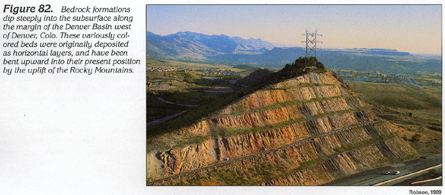 downloadable tiff file C082.tif.gz
(1.9MB compressed)
downloadable tiff file C082.tif.gz
(1.9MB compressed)  downloadable tiff file C083.tif.gz
(2.7MB compressed)
downloadable tiff file C083.tif.gz
(2.7MB compressed) 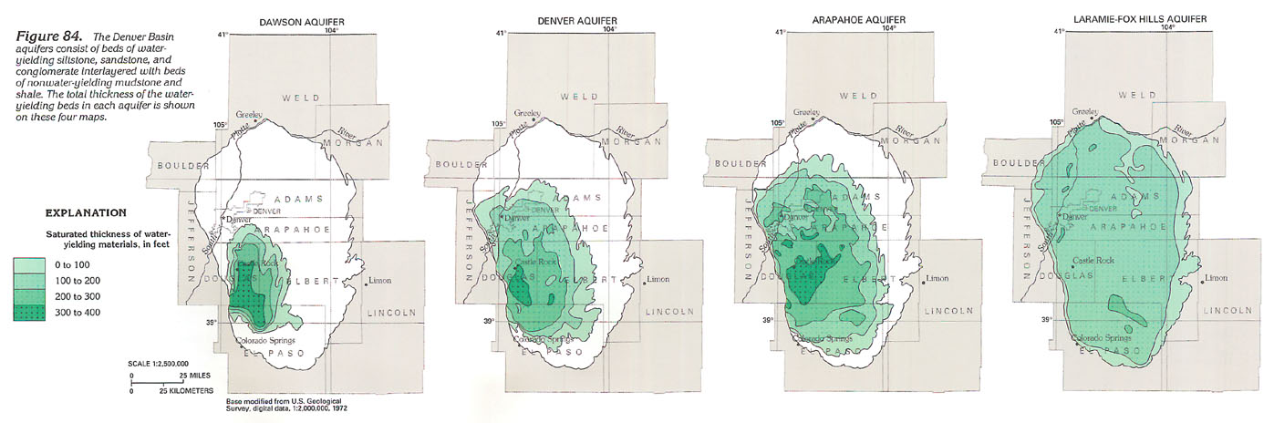 downloadable tiff file C084.tif.gz
(3.2MB compressed)
downloadable tiff file C084.tif.gz
(3.2MB compressed)