GROUND WATER ATLAS of the UNITED STATES
Arizona, Colorado, New Mexico, Utah
HA 730-C
Roswell Basin aquifer system
There are two different files for each illustration
- A 90 ppi JPEG file, suitable for screen viewing is accessed
through the thumbnail image.
- A tiff file is accessed through the "tiff file"
link. All files are Adobe Photoshop. These files have been compressed
with GNU's gzip utility. If your web browser defaults to a screen
display of the file, turn on the "Load to local disk"
option before downloading. Download and process these tiff files
as ascii, not binary.
Hydrogeologic Units
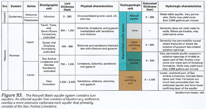
Figure 93 Correlation chart showing the hydrogeologic characteristics
of the Roswell Basin aquifers (260K)
 downloadable tiff file C093.tif.gz (1.8MB
compressed)
downloadable tiff file C093.tif.gz (1.8MB
compressed)
Figure 94 Cross section showing the geologic
and hydrogeologic composition of the Roswell Basin aquifer system
(208K)
 downloadable tiff file C094.tif.gz (1.4MB
compressed)
downloadable tiff file C094.tif.gz (1.4MB
compressed)
Figure 95 Map showing the structure contour of
the base of the alluvium in the Roswell Basin aquifer system (188K)
 downloadable tiff file C095.tif.gz (1.6MB
compressed)
downloadable tiff file C095.tif.gz (1.6MB
compressed)
Figure 96 Cross sections showing the potentiometric
surface of the Roswell Basin aquifer system (328K)
 downloadable tiff file C096.tif.gz (2.5MB
compressed)
downloadable tiff file C096.tif.gz (2.5MB
compressed)
 downloadable tiff file C093.tif.gz (1.8MB
compressed)
downloadable tiff file C093.tif.gz (1.8MB
compressed)  downloadable tiff file C094.tif.gz (1.4MB
compressed)
downloadable tiff file C094.tif.gz (1.4MB
compressed) 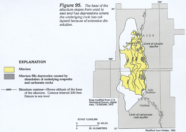 downloadable tiff file C095.tif.gz (1.6MB
compressed)
downloadable tiff file C095.tif.gz (1.6MB
compressed) 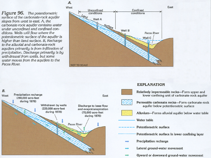 downloadable tiff file C096.tif.gz (2.5MB
compressed)
downloadable tiff file C096.tif.gz (2.5MB
compressed)