GROUND WATER ATLAS of the UNITED STATES
Arizona, Colorado, New Mexico, Utah
HA 730-C
Basin and Range aquifers
There are two different files for each illustration
- A 90 ppi JPEG file, suitable for screen viewing is accessed
through the thumbnail image.
- A tiff file is accessed through the "tiff file"
link. All files are Adobe Photoshop. These files have been compressed
with GNU's gzip utility. If your web browser defaults to a screen
display of the file, turn on the "Load to local disk"
option before downloading. Download and process these tiff files
as ascii, not binary.
Recharge and Discharge
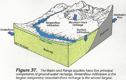
Figure 37 Cross section showing the five principal components
of ground-water recharge into the Basin and Range aquifer (144K)
 downloadable tiff file C037.tif.gz (924K
compressed)
downloadable tiff file C037.tif.gz (924K
compressed)
Figure 38 Cross section showing the five
principal components of ground-water discharge from the Basin
and Range aquifer (144K)
 downloadable tiff file C038.tif.gz (877K
compressed)
downloadable tiff file C038.tif.gz (877K
compressed)
Figure 39 Map showing area of shallow ground-water
discharge by evapotranspiration (184K)
 downloadable tiff file C039.tif.gz (1.4MB
compressed)
downloadable tiff file C039.tif.gz (1.4MB
compressed)
 downloadable tiff file C037.tif.gz (924K
compressed)
downloadable tiff file C037.tif.gz (924K
compressed) 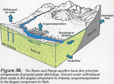 downloadable tiff file C038.tif.gz (877K
compressed)
downloadable tiff file C038.tif.gz (877K
compressed) 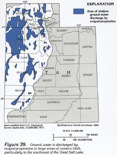 downloadable tiff file C039.tif.gz (1.4MB
compressed)
downloadable tiff file C039.tif.gz (1.4MB
compressed)