GROUND WATER ATLAS of the UNITED STATES
Arizona, Colorado, New Mexico, Utah
HA 730-C
Surficial aquifers
There are two different files for each illustration
- A 90 ppi JPEG file, suitable for screen viewing is accessed
through the thumbnail image.
- A tiff file is accessed through the "tiff file"
link. All files are Adobe Photoshop. These files have been compressed
with GNU's gzip utility. If your web browser defaults to a screen
display of the file, turn on the "Load to local disk"
option before downloading. Download and process these tiff files
as ascii, not binary.
Fresh Ground-water Withdrawals
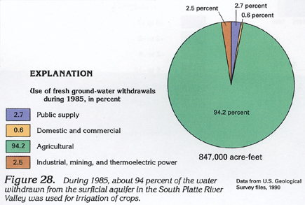
Figure 28 Pie chart showing use of fresh ground-water withdrawals
during 1985 (112K)
 downloadable tiff file C028.tif.gz (867K
compressed)
downloadable tiff file C028.tif.gz (867K
compressed)
Figure 29 Graph showing amount and sources
of ground-water used for irrigation by month (104K)
 downloadable tiff file C029.tif.gz (821K
compressed)
downloadable tiff file C029.tif.gz (821K
compressed)
Figure 30 Graph showing diversion by ground-water withdrawal
and surface-water diversion from year to year (124K)
 downloadable tiff file C030.tif.gz (1MB
compressed)
downloadable tiff file C030.tif.gz (1MB
compressed)
 downloadable tiff file C028.tif.gz (867K
compressed)
downloadable tiff file C028.tif.gz (867K
compressed) 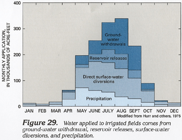 downloadable tiff file C029.tif.gz (821K
compressed)
downloadable tiff file C029.tif.gz (821K
compressed) 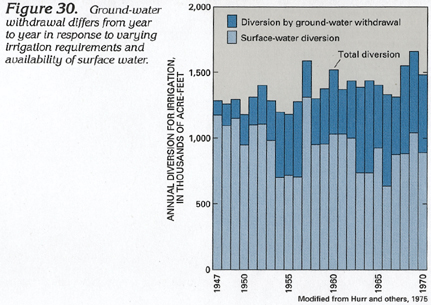 downloadable tiff file C030.tif.gz (1MB
compressed)
downloadable tiff file C030.tif.gz (1MB
compressed)