INTRODUCTION
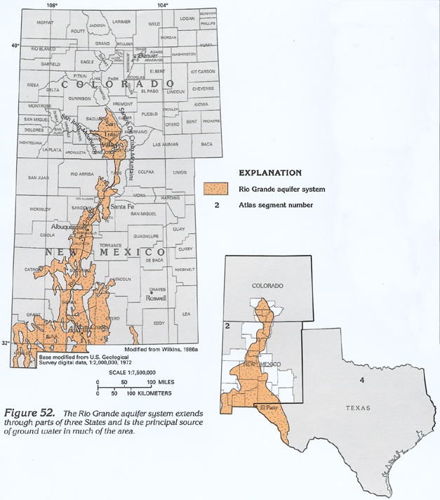
The Rio Grande aquifer system is the principal aquifer in a 70,000-square-mile area of southern Colorado, central New Mexico, and western Texas (fig. 52). The aquifer system consists of a network of hydraulically interconnected aquifers in basin-fill deposits located along the Rio Grande Valley and nearby valleys. The aquifer system corresponds to the eastern part of the Southwest alluvial basins aquifer system, as defined by U.S. Geological Survey Regional Aquifer-System Analysis studies, and is located in the Southern Rocky Mountains and Basin and Range Physiographic Provinces. The part of the aquifer system in Colorado and New Mexico is described in this report; the part in Texas is described in Chapter E of this Atlas.
The basin-fill aquifers of the Rio Grande aquifer system are present in intermountain basins between discontinuous mountain ranges in southern New Mexico and between mountains and tablelands in northern New Mexico. High mountains border the aquifers in southern Colorado. The mountains and edges of the tablelands slope steeply, almost precipitously in some areas, toward the basins. Coalescing alluvial fans lie near the base of many mountains and form the intervening slopes located between the mountains and the relatively flat basin floor. The altitudes of the basin floors range from about 4,000 feet near El Paso, Tex., to about 8,000 feet in the San Luis Valley of Colorado. The altitude of some mountains exceeds 14,000 feet in Colorado, although mountains commonly are 8,000 to 10,000 feet in altitude and extend only 1,000 to 4,000 feet above the basin floors in most of the area.
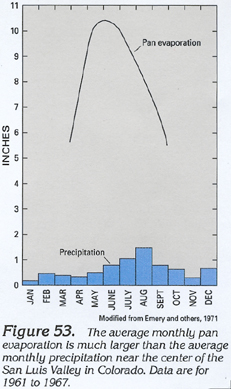
The arid climate of the Rio Grande Valley and adjacent basins provides insufficient precipitation for growth of most commercial crops; consequently, irrigation is required. In the San Luis Valley, for example, the average rate of pan evaporation during a month may be as much as 10 times larger than the average rate of precipitation for the month (fig. 53). The rate of evaporation is large in most of the valley areas because of high summer temperatures, low relative humidity, abundant sunshine, and frequent wind. Much of the area is sparsely vegetated.
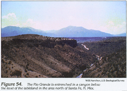
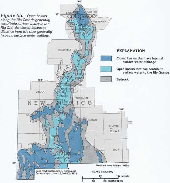
The Rio Grande is the largest river in the area and has perennial flow through most of its length in Colorado and New Mexico. The river flows across the broad basin-fill deposits in the San Luis Valley in Colorado and then flows through about 100 miles of deep canyon (fig. 54) and small intermountain basins in northern New Mexico. South of Santa Fe, N. Mex., the river flows through a series of broad basins and narrow valleys to the State line in southern New Mexico. Most basins along the Rio Grande have surface drainage to the river and are topographically open basins. The northern end of the San Luis Valley and most other basins distant from the river have internal surface-water drainage and are topographically closed basins that generally do not contribute streamflow to the Rio Grande or its tributaries (fig. 55). Much of the streamflow in the more mountainous northern part of the Rio Grande is derived from snowmelt runoff in the mountains. Streamflow in the southern part of the river system is derived from upstream flow, ground-water discharge, and runoff from summer thunderstorms.
HYDROGEOLOGIC UNITS
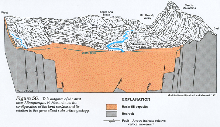
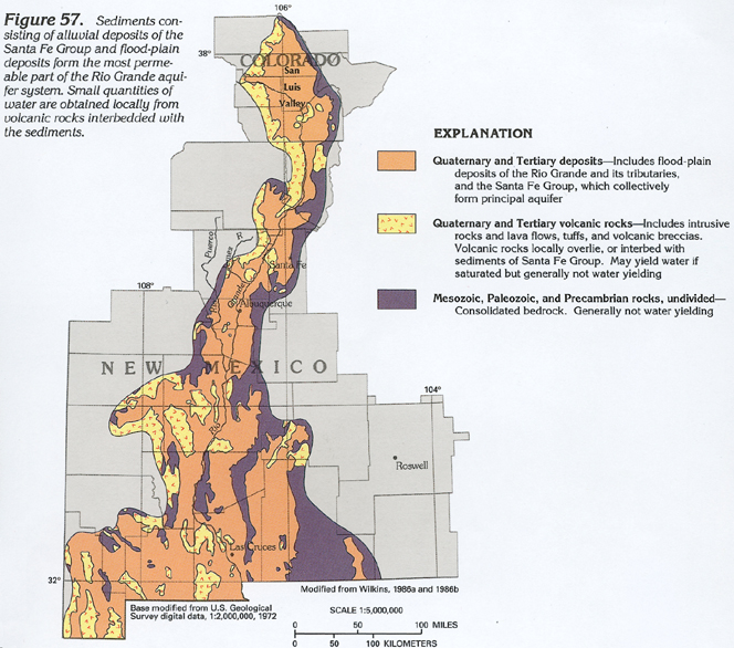
The Rio Grande Rift is the principal geologic feature of the area. The rift affected the configuration of the bounding highlands, which in turn has affected precipitation, runoff, groundwater recharge, source material of the basin fill, aquifer characteristics, and water quality. The rift is a northward-trending series of interconnected, downfaulted and rotated blocks located between uplifted blocks to the east and west. Various blocks have been displaced downward thousands of feet, and most of the rift has been filled with alluvium and volcanic rocks (basin fill). The thickness of the basin fill is unknown in most areas but is estimated to be as much as 30,000 feet in the San Luis Valley, about 20,000 feet near Albuquerque, N. Mex. (fig. 56), and about 2,000 feet near El Paso, Tex. Total vertical displacement across some faults that border the rift exceeds 20,000 feet from the crest of the nearby mountains to the top of the equivalent rocks in the rift. Most basins of the rift are bounded on the north and west by Tertiary and Quaternary volcanic rocks. Igneous, metamorphic, and sedimentary rocks of Precambrian, Paleozoic, and Mesozoic ages (fig. 57) form the eastern boundary of most basins.
The bedrock formations that bound the basins generally consist of granite, quartzite, schist, and gneiss of Precambrian age; marine carbonates, volcanics, and clastic sedimentary rocks of Paleozoic age; and clastic sedimentary rocks and volcanic rocks of Mesozoic and Cenozoic age. Most of the many geologic formations present in this thick sequence of rock are relatively impermeable. Although some volcanic rocks, solution-altered carbonate rocks, or extensively fractured beds can yield water in local areas, the bedrock as a whole has minimal permeability and is considered to form an impermeable base to the Rio Grande aquifer system.
Older and younger basin fill are the principal water-yielding materials in the system. Older basin fill consists of the Santa Fe Group in most of the area and its lateral equivalent, the Gila Conglomerate, in the southwestern part of the aquifer system in New Mexico. The Santa Fe Group is a Tertiary and Quaternary rock-stratigraphic unit that consists of unconsolidated to moderately consolidated lenticular deposits of gravel, sand, and clay interbedded in some areas with andesitic and rhyolitic lava flows, tuffs, and breccias. Younger basin fill consists of unconsolidated, poorly to well-sorted, interbedded Quaternary gravel, sand, silt, and clay. Alluvial fans and pediment-cover deposits near the mountains generally grade imperceptibly into, and intertongue with, either fine-grained playa deposits in valleys or medium- to coarse-grained fluvial deposits. Terrace deposits that consist of gravel, sand, and silt extend 30 to 175 feet above the level of the present flood plain. During late Quaternary time, the Rio Grande was entrenched as much as 60 to 130 feet below the present level of the flood plain. The younger basin fill is similar in appearance and composition to the underlying older basin fill from which the younger unit was largely derived. The contact between the two units generally is about 100 feet below the flood plain and is characterized by subtle changes in lithology and consolidation.
RECHARGE AND DISCHARGE
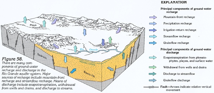
Recharge to the Rio Grande aquifer system primarily originates as precipitation in the mountainous areas that surround the basins. Runoff from snowmelt or rainfall enters the basins and generally flows for short distances across permeable alluvial fans before the water percolates downward through streambeds or evaporates. If the volume of runoff is large or becomes part of a perennial stream, ground-water recharge can be distributed through a much longer reach of stream channel. Some of the precipitation in the mountains supplies water to bedrock aquifers that were formed by fractures or permeable layers in the bedrock. The bedrock aquifers can discharge water directly to the basin-fill aquifer in the subsurface at the mountain front or discharge water to base flow in mountain streams that subsequently recharge the basin-fill aquifers near the mountain front. Such recharge from precipitation in mountainous areas is here termed "mountain-front recharge" and is distributed along the mountainous boundaries of most basins, as indicated in figure 58. Larger quantities of recharge generally occur along the higher mountains in the northern parts of the aquifer system.
Runoff produces most mountain-front recharge to the aquifer system. However, in some mountainous areas, thick and extensive layers of volcanic rocks are sufficiently permeable to enable large volumes of water to flow through the rocks and directly recharge the basin-fill aquifers. The San Juan Mountains to the west and the Sangre De Cristo Mountains to the east of the San Luis Valley provide a contrast in this regard. About one-half of the approximately 2,000,000 acre-feet per year flow of water that enters the San Luis Valley from the San Juan Mountains is through bedrock aquifers in extensive layers of volcanic rocks that extend from the mountains into the basin fill. The much smaller drainage area of the Sangre De Cristo Mountains is underlain by relatively impermeable Paleozoic sedimentary rocks and Precambrian crystalline rocks and yields only about 250,000 acre-feet per year of water to the valley; almost all this water is streamflow. Therefore, mountain-front recharge can be affected by many factors, principally the quantity of precipitation in the mountains, the size of the drainage area, the geology of the bedrock, and the size and flow characteristics of the streams that issue from the mountains.
Most of the precipitation that falls in the valleys is lost to evaporation and transpiration, and little water percolates to a depth sufficient to recharge the basin-fill aquifers. The rate of precipitation recharge is affected by many factors, including quantity and duration of precipitation, soil-moisture content, rate of evapotranspiration, topography, soil permeability, and depth to ground water. Estimated rates of precipitation recharge are essentially zero in areas subject to a combination of little precipitation, substantial evapotranspiration, steep land surface, relatively impermeable soil, and deep water table. In a few areas, primarily in stream valleys with highly permeable soil and shallow depth to water, precipitation recharge may exceed 0.2 inch per year.
Streamflow that extends beyond the mountain front provides an important source of recharge to the basin-fill aquifers. Permeable sediments in alluvial fans and pediments enable rapid infiltration of surface water; most of the water ultimately reaches the water table, which may be 100 feet or more below the land surface in these areas. Near the Rio Grande and the central parts of most closed basins, water levels are near land surface (or above land surface in a few areas), and streamflow recharge may be limited by the shallow water levels. Water-level declines caused by ground-water withdrawal may lower the water level near a stream enough to enable additional recharge from streamflow. This induced recharge lessens the water-level declines and can supply much of the water withdrawn from the well. Between 1920 and 1960, induced recharge of streamflow from the Rio Grande supplied about 80 percent of the ground water withdrawn near Albuquerque, N. Mex.
Irrigation-return recharge is an important component of ground-water recharge in areas of extensive irrigated agriculture. Some of the water diverted from the Rio Grande through canals and some of the water applied to fields from canals or wells percolates below the root zone of vegetation and recharges the basin-fill aquifers.
Underflow recharge occurs where ground water flows into a basin from an adjoining area or basin. Most underflow is in the basin fill present in bedrock valleys between adjacent basins. Where bedrock valleys are narrow or the basin fill is thin, as between several basins along the Rio Grande, underflow is small, and surface water that flows through the valley can provide the principal hydraulic connection between basins. Where bedrock valleys are broad or the basin fill is thick, as between most basins remote from the Rio Grande, underflow recharge may constitute a large part of the total recharge to a basin.
Ground water discharges from the Rio Grande aquifer system by evapotranspiration, withdrawal from wells and drains, discharge to streamflow, and underflow (fig. 58). In the arid climate of New Mexico and southern Colorado, rates of evapotranspiration are large, and water is readily lost by evaporation from moist soil and water surfaces and by transpiration from vegetation. Evapotranspiration annually removes about 2,800,000 acre-feet per year of water from the 1,700,000-acre area of the San Luis Valley. This is a rate of about 20 inches per year from an area that receives about 10 inches per year of precipitation and has about 60 inches per year of potential evaporation. In the southern part of the Rio Grande aquifer system, precipitation is less than 8 inches per year, and potential evaporation exceeds 100 inches per year; the rate of evapotranspiration likely is greater than 20 inches per year in this area.
Ground-water withdrawal primarily occurs as discharge from pumping wells. In 1985, about 1 million acre-feet of ground water was withdrawn from the Rio Grande aquifer system. About 90 percent of this water was used for irrigation of commercial crops. Public water supplies for most cities and communities in the area rely on ground water, and withdrawal for municipal use is a small but important component of the total withdrawal.
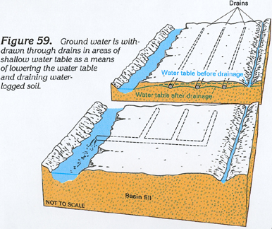
Ground water also is withdrawn through drains. In some low-lying areas, irrigation-return recharge has caused the water table to rise so near land surface that waterlogged soil prevents agricultural use of the land. Shallow water tables are prevalent in the part of the Rio Grande Valley near the river and in the closed basin in the northern part of the San Luis Valley. Drains have been installed in many of these areas to remove shallow ground water and thus lower the water table (fig. 59). Withdrawal occurs as shallow ground water flows into the drains, which generally discharge to the Rio Grande at a point downstream from the drained fields. The total volume of flow to drains is not known but is small in comparison to the discharge from pumping wells.
Ground water discharges to the Rio Grande and its tributaries along much of the length of the river, and discharge to streamflow is an important component of ground-water discharge (fig. 58). Streamflow in the Rio Grande and its tributaries is strongly affected by the altitude of the ground water in the basin fill near the river. A close hydraulic connection between the river and the aquifer moderates water-level changes in the aquifer near the river by means of captured discharge. Captured discharge occurs when ground-water withdrawal causes a decrease in the flow of ground water to the river. Ground water that was discharged to the river under natural conditions is discharged through the well, and water-level declines in the well are moderated. If a pumping well is located near enough to the river, induced recharge or captured discharge can cause a reduction in streamflow equal to the withdrawal rate from the well.
Underflow discharge occurs where ground water flows out of a basin into an adjoining basin. This discharge process has been discussed above in terms of underflow recharge.
WATER-LEVEL CONDITIONS
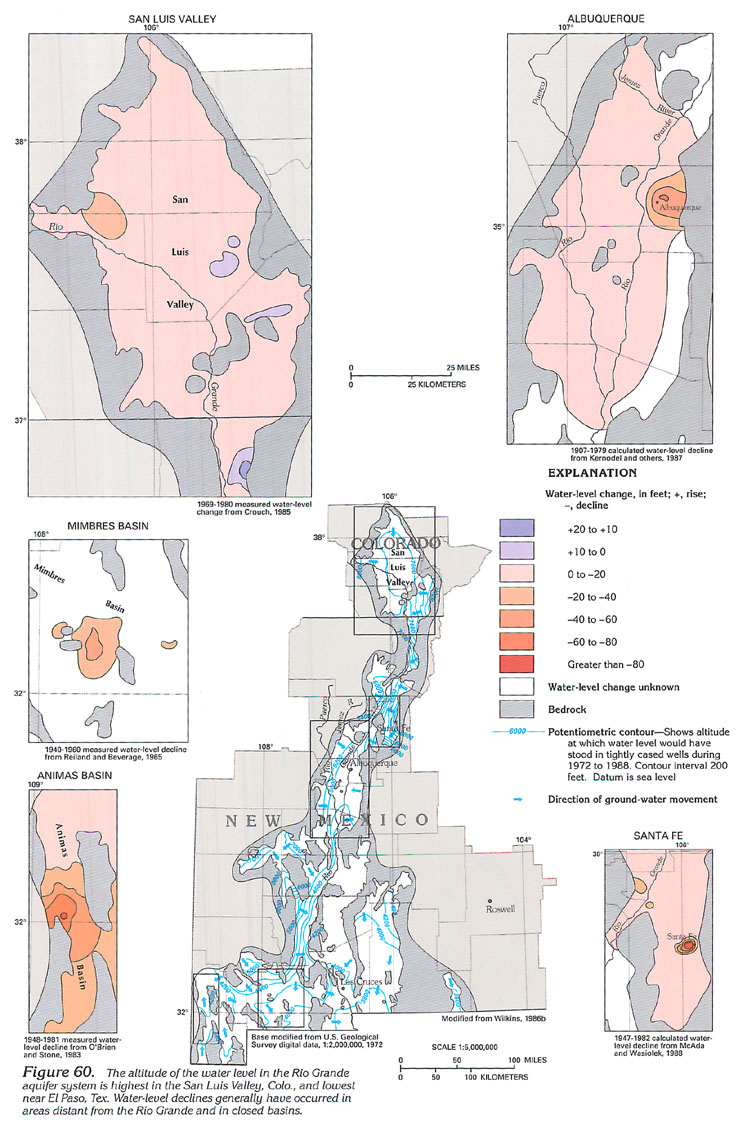
Ground-water levels in the Rio Grande aquifer system (fig. 60) range in altitude from more than 8,000 feet in the northern part of the aquifer system to less than 3,800 feet in the southern part (near El Paso, Tex.). Although large differences in water-level altitude are present across the aquifer system, ground-water flow primarily is controlled by differences in water levels within individual basins. The smaller differences in water-level altitude within basins are the result of local differences in the rate and distribution of mountain-front and other recharge, and the altitude and location of areas of ground-water discharge, such as the Rio Grande.
Water levels in open basins drained by the Rio Grande generally are higher near the margins of the basin and lower near the river. Differences in water-level altitude within these basins generally range from about 600 to 800 feet. Ground water flows from recharge areas along the margins of the basins toward the river. Ground water discharges to the river or to drains, pumping wells, or evapotranspiration in areas near the river. Relatively small quantities of ground water flow through the narrow basin-fill areas between the broader basins.
Water levels in closed basins tend to be higher near the margins of the basin, but these basins do not have a stream as a principal discharge area. Discharge generally occurs as underflow into adjoining basins, as discharge from pumping wells, or as evapotranspiration from areas of shallow water table near playas.
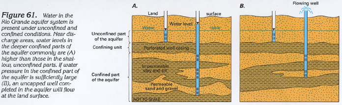
Beds of relatively impermeable clay, silt, or unfractured volcanic rocks that are thick and extensive can retard the vertical movement of ground water and cause large differences in water levels between shallow wells and nearby deep wells (fig. 61A). (A relatively impermeable bed is called a confining unit if it restricts vertical movement of water.) In some areas, the pressure in the confined part of the aquifer is large enough to cause the water level in a well completed in the aquifer to rise above land surface, and water may flow freely from the well (fig. 61B). In the San Luis Valley, for example, a confining unit that consists of interlayered clay, silt, sand, and unfractured volcanic rocks is in excess of 1,200 feet thick near the center of the valley and extends through the subsurface of much of the valley. Depth to water in an unconfined part of the aquifer that overlies the confining unit ranges from 0 to about 100 feet below land surface. Water levels in the few wells completed in the confined part of the aquifer generally are higher than those in the unconfined part, and flowing wells are present in the lower part of the valley. In many low-lying areas of the Rio Grande Valley, water levels are higher in deep wells than in shallow wells; flowing wells also are present in some of these areas.
Ground-water withdrawal from wells and drains has caused long-term water-level declines in some parts of the aquifer system. When rates of withdrawal have been large in closed basins, or in parts of open basins that are remote from the Rio Grande, large water-level declines have occurred as ground water is removed from storage in the aquifers. Extensive development in closed basins generally has produced the largest water-level declines. For example, in the Animas basin near the southwestern margin of the aquifer system, groundwater withdrawal for agricultural use caused more than 80 feet of-water-level decline between 1948 and 1981 (fig. 60). In the nearby Mimbres basin, similar water use caused as much as 50 feet of water-level decline between 1940 and 1960. Withdrawal for irrigation and municipal use in areas remote from the Rio Grande near Albuquerque, N. Mex., caused about 60 feet of water-level decline between 1907 and 1979 and caused about 100 feet of water-level decline between 1947 and 1982 near Santa Fe, N. Mex.
Ground-water withdrawal from wells located near the Rio Grande or its perennial tributaries generally does not cause long-term water-level declines in the aquifer. Withdrawal in these areas can be offset by induced recharge and captured discharge, and the water removed from the aquifer is replenished by water from surface sources. In the San Luis Valley, for example, ground-water levels are near the altitude of the river and have changed little since ground-water development began.
GROUND-WATER QUALITY
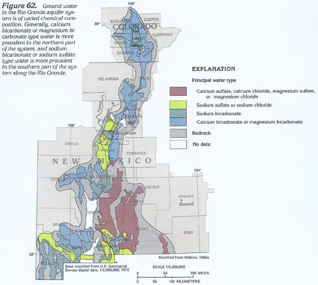
The chemical composition and dissolved-solids concentration of water in the Rio Grande aquifer system are affected by the quality of the water that enters the aquifer, the type and solubility of minerals present in the basin fill, and the quantity of water lost by evaporation and transpiration. Soluble minerals present in the rocks of the mountains adjacent to the basins affect the quality of the water draining from the mountains, which, in turn, affects the quality of the recharge entering the aquifers. Water in the aquifer system is of varied chemical composition (fig. 62), in part because of the varied geology of the nearby mountains. Surface water in the Rio Grande in the reach from the headwaters to near Albuquerque, N. Mex., generally has a small dissolved-solids concentration and contains a preponderance of calcium, bicarbonate, and sulfate ions. This water is classified as a calcium bicarbonate or calcium sulfate type. Ground water near recharge areas and in the northern part of the aquifer system generally is a calcium or magnesium bicarbonate type. Streamflow in the Jemez River (to the northwest of Albuquerque) and the Rio Puerco (to the southwest of Albuquerque) has a larger dissolved-solids concentration than the Rio Grande, and the water is a sodium chloride or sodium sulfate type. Ground water near these streams is of similar chemical composition. Differences in chemical composition and dissolved-solids concentration of recharge to other parts of the aquifer system produce most of the areal differences in ground-water quality shown in figures 62 and 63.
As ground water flows through the basin fill, soluble minerals such as calcite and dolomite (calcium and magnesium carbonates), gypsum (calcium sulfate), halite (rock salt), and many other minerals are dissolved from the sediments. This dissolution increases the dissolved-solids concentration of the ground water and may alter the chemical composition of the water. Clay minerals also may alter the composition of the water through the process of cation exchange. This natural water-softening process involves the exchange of calcium or magnesium ions in solution for sodium ions that are bound to some clay minerals. For example, a hard water of a calcium bicarbonate type could exchange the calcium ions for the sodium ions on the clay and become a soft water of a sodium bicarbonate type. The calcium ions that formerly were in solution become immobile on the clay minerals. Water in the aquifer system ranges locally from soft to very hard, but softer water is more prevalent in parts of the aquifer system in Colorado and northern and southwestern New Mexico.
Water loss to evapotranspiration has an important effect on ground-water quality in areas of irrigated agriculture, near playas, and other areas of shallow water table. Evapotranspiration removes water from the aquifer or the soil but does not remove the minerals that formerly were dissolved in the water. These minerals can accumulate in the soil to form alkali deposits or salt flats or can be flushed from the soil by infiltration of precipitation or irrigation water. Additional dissolved solids carried into the aquifer from such surficial sources can form a zone of degraded ground-water quality at the top of the aquifer (fig. 64). In the lower Rio Grande Valley near Las Cruces, N. Mex., infiltration of irrigation water has produced a slightly saline zone (1,000-3,000 milligrams per liter dissolved solids) that is about 100 to 150 feet thick at the top of the aquifer. A transition zone of intermediate salinity (500-1,000 milligrams per liter dissolved solids) that is 50 to 100 feet thick separates the slightly saline zone from the underlying freshwater zone (300-500 milligrams per liter dissolved solids) that extends to depths of 1,000 to 1,500 feet. A second transition zone separates the freshwater zone from the deep saline zone where dissolved-solids concentrations can exceed 3,000 milligrams per liter. Similar stratification of water of large dissolved-solids concentration in the upper part of the aquifer occurs in the San Luis Valley, much of the lower Rio Grande Valley near the river, and in many of the closed basins where playas are major discharge areas.
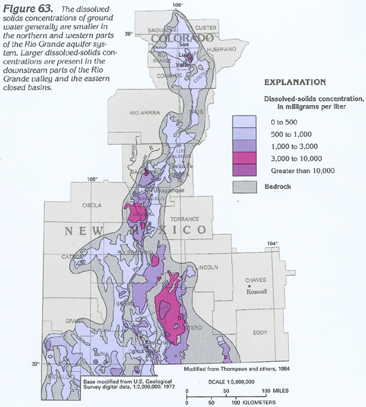
Evapotranspiration and tributary inflow produce a general downgradient increase in dissolved-solids concentrations along the valley of the Rio Grande (fig. 63). The dissolved-solids concentration of most ground water is about 230 milligrams per liter north of Santa Fe, N. Mex., and about 410 milligrams per liter in the reach from Santa Fe to about 50 miles south of Albuquerque; farther south, most ground water contains between 600 and 700 milligrams per liter dissolved solids.
FRESH GROUND-WATER WITHDRAWALS
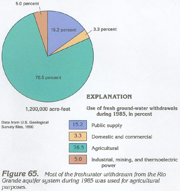
Withdrawals of freshwater from the Rio Grande aquifer system totaled about 1,200,000 acre-feet during 1985. Agriculture used about 900,000 acre-feet or about 77 percent of the ground water withdrawn (fig. 65). Public supply, primarily for the cities of Albuquerque, Las Cruces, and Santa Fe, N. Mex., used about 180,000 acre-feet or about 15 percent of the ground water withdrawn. Domestic and commercial, and industrial, mining, and thermoelectric power uses constituted the remaining approximately 8 percent.