GROUND WATER ATLAS of the UNITED STATES
Kansas, Missouri, and Nebraska
HA 730-D
High Plains aquifer
There are two different files for each illustration
- A 72 ppi GIF file, suitable for screen viewing is accessed through
the thumbnail image
- An eps file, suitable for downloading to be printed or edited is accessed
through the "eps file" link. Most files are Adobe Illustrator
6.0, exceptions are noted. These files have been compressed with GNU's
gzip utility. If your web browser defaults to a screen display of the file,
turn on the "Load to local disk" option before downloading. Download
and process these eps files as ascii, not binary.
Hydrogeologic units
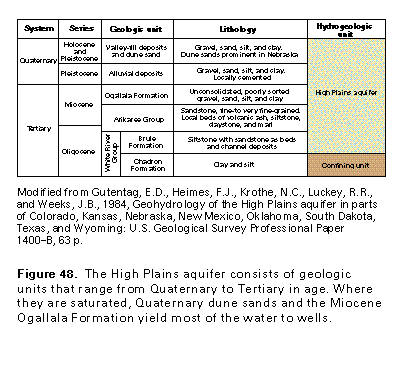
Figure 48 Correlation chart (17K)
 editable eps
file D048.eps.gz (50K compressed)
editable eps
file D048.eps.gz (50K compressed)
Figure 49 Geology map (33K)
 editable eps file D049.eps.gz
(314K compressed)
editable eps file D049.eps.gz
(314K compressed)
Figure 50 Diagramatic cross section (17K)
 editable eps file D050.eps.gz
(50K compressed)
editable eps file D050.eps.gz
(50K compressed)
Figure 51 Photo showing loess and windblown silt deposits
(50K)
 This illustration contains a placed image. Download the Adobe Illustrator
6 eps file D051.eps.gz (4.9M compressed)
which contains an imbedded Adobe Photoshop 3 (eps) file. You may also want
to download the editable Photoshop
file D051psh.eps.gz (4.9M compressed)
This illustration contains a placed image. Download the Adobe Illustrator
6 eps file D051.eps.gz (4.9M compressed)
which contains an imbedded Adobe Photoshop 3 (eps) file. You may also want
to download the editable Photoshop
file D051psh.eps.gz (4.9M compressed)
Figure 52 Map showing the geologic units underlying the High
Plains aquifer (33K)
 editable eps file D052.eps.gz
(215K compressed)
editable eps file D052.eps.gz
(215K compressed)
 editable eps
file D048.eps.gz (50K compressed)
editable eps
file D048.eps.gz (50K compressed) 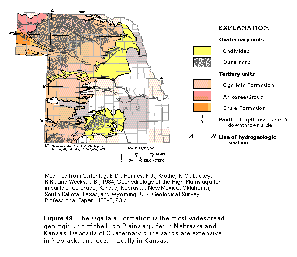 editable eps file D049.eps.gz
(314K compressed)
editable eps file D049.eps.gz
(314K compressed) 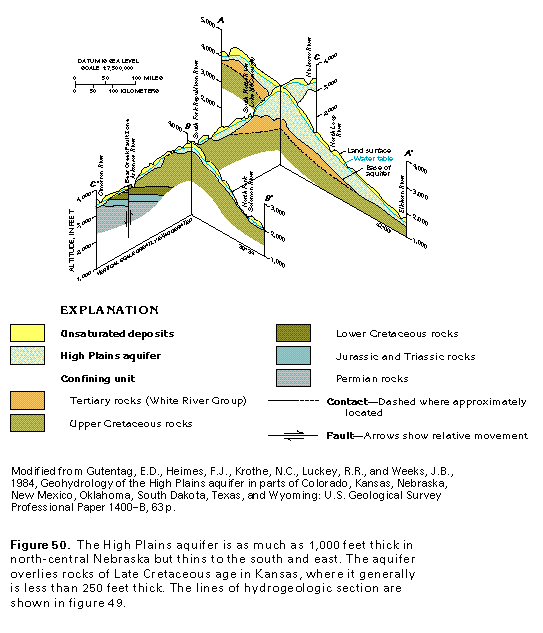 editable eps file D050.eps.gz
(50K compressed)
editable eps file D050.eps.gz
(50K compressed) 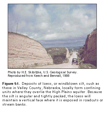 This illustration contains a placed image. Download the Adobe Illustrator
6 eps file D051.eps.gz (4.9M compressed)
which contains an imbedded Adobe Photoshop 3 (eps) file. You may also want
to download the editable Photoshop
file D051psh.eps.gz (4.9M compressed)
This illustration contains a placed image. Download the Adobe Illustrator
6 eps file D051.eps.gz (4.9M compressed)
which contains an imbedded Adobe Photoshop 3 (eps) file. You may also want
to download the editable Photoshop
file D051psh.eps.gz (4.9M compressed) 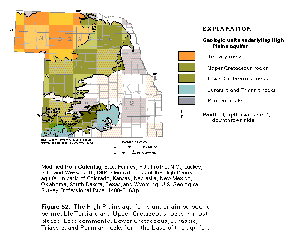 editable eps file D052.eps.gz
(215K compressed)
editable eps file D052.eps.gz
(215K compressed)