GROUND WATER ATLAS of the UNITED STATES
Kansas, Missouri, and Nebraska
HA 730-D
Regional summary
There are two different files for each illustration
- A 72 ppi GIF file, suitable for screen viewing is accessed through
the thumbnail image
- An eps file, suitable for downloading to be printed or edited is accessed
through the "eps file" link. Most files are Adobe Illustrator
6.0, exceptions are noted. These files have been compressed with GNU's
gzip utility. If your web browser defaults to a screen display of the file,
turn on the "Load to local disk" option before downloading. Download
and process these eps files as ascii, not binary.
Vertical sequence of aquifers
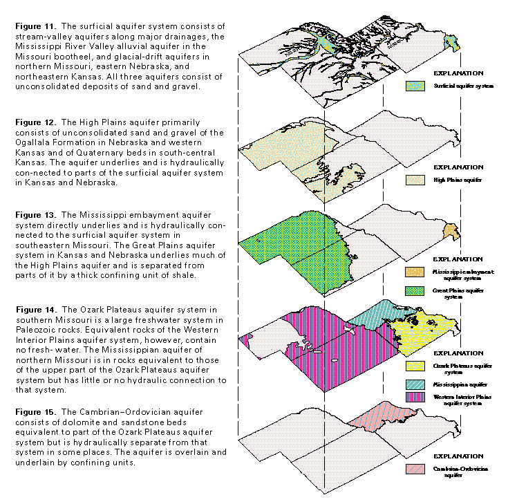
Figure 11 Map of Surficial aquifer system extent (50K)
 editable eps
file D011.eps.gz (908K compressed)
editable eps
file D011.eps.gz (908K compressed)
Figure 12 Map of High Plains aquifer extent (50K)
 editable eps file D012.eps.gz
(908K compressed)
editable eps file D012.eps.gz
(908K compressed)
Figure 13 Map of Mississippi embayment and Great Plains aquifer
system extents (50K)
 editable eps file D013.eps.gz
(908K compressed)
editable eps file D013.eps.gz
(908K compressed)
Figure 14 Map showing aquifer extents (50K)
 editable eps file D014.eps.gz
(908K compressed)
editable eps file D014.eps.gz
(908K compressed)
Figure 15 Map of Cambrian-Ordovician aquifer extent (50K)
 editable eps file D015.eps.gz
(908K compressed)
editable eps file D015.eps.gz
(908K compressed)
 editable eps
file D011.eps.gz (908K compressed)
editable eps
file D011.eps.gz (908K compressed)  editable eps file D012.eps.gz
(908K compressed)
editable eps file D012.eps.gz
(908K compressed)  editable eps file D013.eps.gz
(908K compressed)
editable eps file D013.eps.gz
(908K compressed)  editable eps file D014.eps.gz
(908K compressed)
editable eps file D014.eps.gz
(908K compressed)  editable eps file D015.eps.gz
(908K compressed)
editable eps file D015.eps.gz
(908K compressed)