SURFICIAL AQUIFER SYSTEM
INTRODUCTION
The surficial aquifer system in Segment 3 consists of unconsolidated sand and gravel and is divided into three parts: stream-valley aquifers, the Mississippi River Valley alluvial aquifer, and glacial-drift aquifers. These aquifers are hydraulically connected in some places. For example, many of the glacial-drift aquifers in northern Missouri, northeastern Kansas, and eastern Nebraska occupy ancient stream channels that have been eroded into bedrock. At locations where modern streams follow the ancient drainage patterns, the alluvial deposits of sand and gravel that compose a stream-valley aquifer may lie directly on glacial outwash that also consists of sand and gravel. Much of the sand and gravel of the stream-valley aquifers in Missouri and eastern Kansas and Nebraska has been reworked from older glacial-drift deposits and, therefore, may be difficult to distinguish from glacial outwash. Most of the water in the surficial aquifer system is under unconfined conditions.
STREAM-VALLEY AQUIFERS
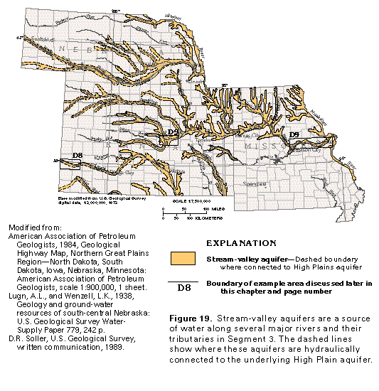
The stream-valley aquifers of Segment 3 consist of narrow bands of fluvial and alluvial sediments which fill or partly fill the valleys of meandering to braided streams that have eroded shallow channels into glacial deposits, older unconsolidated alluvium, or bedrock. Where these streams cross the High Plains aquifer, the stream-valley aquifers are hydraulically connected to and are considered to be part of the underlying High Plains aquifer. Locally, the stream-valley aquifers are hydraulically connected to bedrock aquifers, but, in most places, they are separated from the bedrock aquifers by poorly permeable beds of clay or shale. The extent of the stream-valley aquifers is shown in figure 19.
The unconsolidated sand and gravel deposits that compose the stream-valley aquifers are thicker, more widespread, and more productive in the valleys of the larger rivers than those of smaller streams. In Kansas, stream-valley aquifers are along the courses of the Republican, the Kansas, the Missouri, the Solomon, the Saline, the Neosho, the Smoky Hill, the Marais des Cygnes, the Arkansas, and the Cimarron Rivers. In Missouri, the stream-valley aquifers along the Missouri and the Mississippi Rivers and their tributaries are important sources of freshwater for many communities and industries. Stream-valley aquifers occur along the Missouri, the Niobrara, the Loup, the Platte, the Republican, and the Blue Rivers in Nebraska. No comprehensive, unified study has been done for the stream-valley aquifers; accordingly, local investigations have been selected to show their hydrology. The designated boundaries D8 and D9 in figure 19 are the locations of detailed studies of the stream-valley aquifers, which are described in the following sections of this report.
The stream-valley aquifers consist mostly of sand and gravel of Holocene age but locally include sediments of Pleistocene age. The average thickness of the aquifers is about 90 to 100 feet, but locally they are as much as 160 feet thick. However, the average thickness of saturated alluvial material is less and generally ranges from 50 to 80 feet; the thicker saturated sections yield more water to wells.
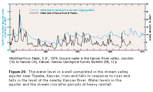
Most of the water in the stream-valley aquifers is under unconfined, or water-table, conditions. Locally, where coarse-grained aquifer sediments are capped by poorly permeable silt or clay, confined (artesian) conditions exist. The stream-valley aquifers are in direct hydraulic connection with the adjacent streams and water levels in the aquifers are, therefore, closely related to river levels (fig. 20). Aquifer and river water levels rise following precipitation events; the rise in the wa-ter level of the river precedes that in the aquifer.
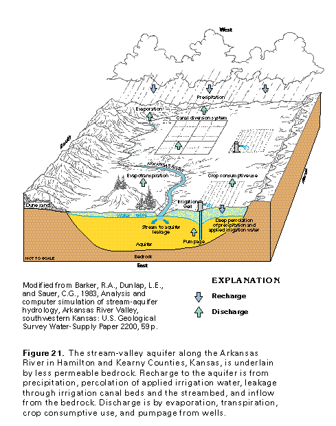
Recharge to a typical stream-valley aquifer is by precipitation that falls directly on the aquifer, seepage through the beds of streams and of reservoirs and canals constructed in the stream valleys, downward percolation of applied irrigation water (fig. 21), and ground-water inflow from underlying, permeable bedrock. The aquifer discharges by leakage to streams and canals, pumpage from wells, and evapotranspiration (evaporation plus transpiration by plants, especially crops during the growing season). A small amount of water is consumed by crops. Along reaches of some streams, such as the Arkansas, the Smoky Hill, and the Solomon, some of the water potentially available to recharge the aquifer from the stream is diverted by networks of canals and irrigation ditches, from which evaporation occurs. Such diversions, coupled with intense irrigation pumpage from the aquifer and a resulting decrease in base flow to the stream, have severely reduced streamflow. In some cases, streams that were formerly perennial are now dry most of the year.
The stream-valley aquifers are reliable sources of ground water because of the coarse-grained nature and high permeability of the aquifer material. Yields that range from 100 to 1,000 gallons per minute commonly are reported for wells completed in these aquifers; maximum yields of more than 1,500 to 2,500 gallons per minute are reported locally in Nebraska and Missouri, respectively, and yields of as much as 3,000 gallons per minute are reported from stream-valley aquifers in Kansas. Reported transmissivity values for these aquifers, as calculated from aquifer tests, range from 8,000 to 80,000 square feet per day.
The chemical quality of the water in the stream-valley aquifers generally is suitable for most uses. Typically, the water is hard and a calcium bicarbonate type. Dissolved-solids concentrations generally are less than 500 milligrams per liter but locally are as much as 7,000 milligrams per liter; the larger concentrations reflect an influx of water with large chloride or sulfate concentrations from underlying aquifers or from irrigation return flow. Large iron concentrations are common.
Arkansas River Valley, Southwestern Kansas
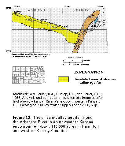
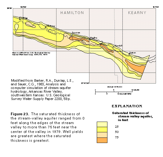
The stream-valley aquifer that borders the Arkansas River in southwestern Kansas (area D8 in fig. 19) has been studied along a 48-mile reach of the river between the Colorado-Kansas State line and a geologic structure called the Bear Creek Fault Zone (fig. 22). This zone is thought to have been formed by the collapse of bedrock following dissolution of underlying salt beds. East of this zone the stream-valley aquifer is hydraulically connected to the High Plains aquifer and is, therefore, considered to be part of it. The stream-valley aquifer shown in figure 22 primarily comprises alluvial sand and gravel that fill a valley which is as much as 5 miles wide and has been eroded into poorly permeable Cretaceous bedrock. The sand and gravel range in thickness from 0 to 125 feet and generally are thickest near the center of the valley; however, the saturated thickness of this permeable material is less than 75 feet except in small areas (fig. 23). Well yields are directly proportional to saturated thickness. Where the saturated thickness is 25 feet or less, well yields are between 100 and 500 gallons per minute, but where saturated thickness is 75 feet or more, yields that range from 1,000 to 3,000 gallons per minute have been reported.
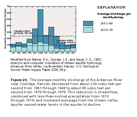
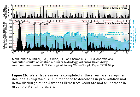
The Arkansas River and the stream-valley aquifer are hydraulically connected and water moves freely from the aquifer into the stream or from the stream into the aquifer, depending upon the relative position of the water levels in the stream and aquifer. The flow of the Arkansas River is impounded by the John Martin Reservoir in Colorado, about 50 miles upstream from the Colorado-Kansas State line, and water is released from the reservoir during the growing season to supply downstream irrigation ditches and canals. Beginning about 1970, the flow of the river was insufficient to meet irrigation needs near the river in southwestern Kansas (fig. 24), partly because of increased diversions upstream. The river was a perennial stream throughout the studied 48-mile reach until 1975 but was dry most of the year east of (downstream from) Kendall from 1975 through 1980. Accordingly, farmers who used ditch irrigation changed from surface water to ground water as a source of irrigation supply; this change, coupled with increased development, caused withdrawals from the stream-valley aquifer to more than triple between 1970, when about 20,000 acre-feet per year was pumped, and 1979, when withdrawals were about 65,000 acre-feet per year. (One acre-foot is the volume of water that will cover 1 acre of land to a depth of 1 foot, or about 43,560 cubic feet of water.) The combination of decreased streamflow from Colorado, less-than-normal precipitation, and increased pumpage caused water levels in the aquifer to decline 4 feet in the western part of Hamilton County (fig. 25) and more than 25 feet in Kearny County.
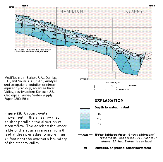
Water in the stream-valley aquifer moves from west to east (fig. 26) and follows the eastward slope of the topography of the valley floor. Movement of the water in the aquifer is nearly parallel to streamflow. In places, the altitude of the water table is below the altitude of the stream, and the contours show a slight "v" that points in a downstream direction (for example, the area near Medway). In other places, the contours "v" slightly upstream (for example, near Mayline), which indicates the aquifer is discharging to the stream. The lack of sharp, well-defined "v" points on the contours indicates good hydraulic connection between the stream and the aquifer. The depth to the water table also is shown in figure 26. The water table is nearest to land surface near the river and is deepest near the edge of the valley.
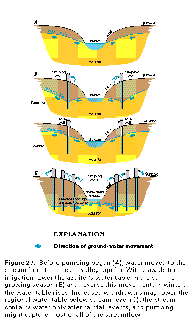
Water levels in the stream-valley aquifer and in the streams to which it is connected vary seasonally in response to pumping from the aquifer. The effects of pumping are summarized in figure 27. Before withdrawals began, the water table in the aquifer was above the water level in the stream, and the aquifer discharged to the stream as shown in figure 27A. Wells installed to provide irrigation supplies can greatly lower the water table in the aquifer, especially during the summer, when crop growth rate is highest and water demands are greatest. At such times, ground-water movement can be reversed from that before pumping began (fig. 27B), and water can move from the stream to recharge the aquifer. When irrigation pumping ceases during the winter months, movement of water from the aquifer to the stream is reestablished; however, water levels may not recover fully to those before pumping began. If pumping is greatly increased (fig. 27C), however, then the regional water table may decline to a level below the streambed; the stream will flow only after periods of heavy rainfall and will lose water to the aquifer during all seasons. This condition exists along some reaches of the Arkansas River in Kansas.
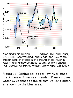
The hydrographs in figure 28 show the response of the water level in a well 100 feet from the Arkansas River near Kendall to changes in the river stage. From 1979 through 1981, the water level in the aquifer near the river was generally below or at the same level as the river stage. Thus, the river is a losing stream here and contributes water to the aquifer. The hydrograph shows that the river ceased to flow for several months in late 1979; thus, the aquifer received no recharge from the stream.
Smoky Hill, Saline, And Solomon River Valleys, Central Kansas
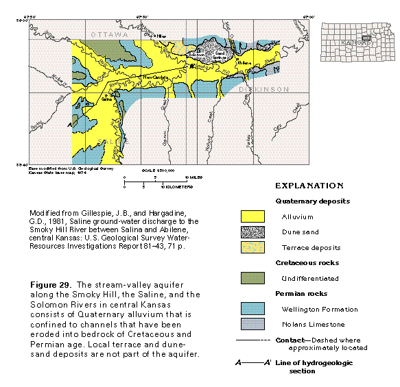
The stream-valley aquifer along parts of the Smoky Hill, the Saline, and the Solomon Rivers (area D9 in fig. 19) ranges in width from about 3 to 5 miles (fig. 29). The lower two-thirds of the aquifer generally consists of coarse-grained alluvial deposits, whereas the upper third is finer grained material. The uplands adjacent to the rivers are underlain by sandstone, shale, and limestone of Cretaceous to Permian age (fig. 29), all of which are less permeable than the alluvium. Locally, the stream-valley alluvium is bordered by Quaternary dune sands and poorly sorted terrace deposits that are mostly unsaturated and not part of the stream-valley aquifer. Shale beds underlie the stream-valley aquifer and form a confining unit that separates the aquifer from permeable beds in the Hutchinson Salt Member of the Wellington Formation of Permian age.
Wells completed in the coarse-grained, lower part of the stream-valley aquifer commonly yield from 200 to 900 gallons per minute. Transmissivity values determined from aquifer tests in this part of the alluvium range from 8,000 to 13,000 feet squared per day. The water in the aquifer generally is unconfined. The stream-valley aquifer is in direct hydraulic contact with the three rivers and discharges water to them.
The stream-valley aquifer mostly contains freshwater in its upper 35 to 50 feet in the area shown in figure 29. Below the freshwater from Salina eastward, the aquifer contains saline water, some of which discharges to some reaches of the rivers. During a period of stable base flow in 1976-77, the chloride concentration in water from the Smoky Hill River increased about 800 milligrams per liter in the reach of the river between New Cambria and Sand Springs. In the same period, an increase in chloride concentration of about 550 milligrams per liter was observed in water from the Solomon River in the reach between Niles and Solomon. Chloride concentrations as large as 73,000 milligrams per liter have been reported in water from the lower part of the stream-valley aquifer. Withdrawals from the aquifer in this part of central Kansas are small because of the poor quality of the water.
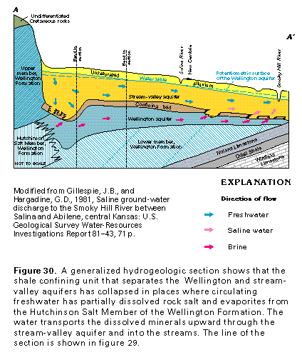
The source of the saline water and brine in the stream-valley aquifer is the Hutchinson Salt Member of the Wellington Formation (fig. 30). Fresh ground water from the alluvial aquifer has circulated downward and dissolved some of the salt and evaporite beds in the Hutchinson Salt Member and the unnamed lower member of the Wellington Formation. Where this dissolution locally has increased the porosity and permeability of the Wellington, the formation is called the Wellington aquifer. Collapse structures have formed in the shale confin-ing unit that separates the Wellington and the stream-valley aquifers and allow brine to move upward from the Wellington aquifer (fig. 30) to the stream-valley aquifer. The brine is diluted as it mixes with freshwater and moves through the stream-valley aquifer to discharge into the Smoky Hill and the Solomon Rivers.
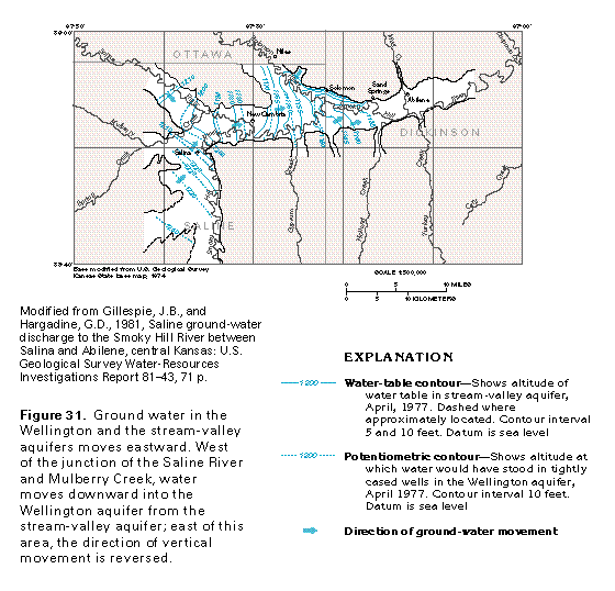
Water in the stream-valley and the Wellington aquifers generally moves from west to east, parallel to the direction of flow of the Smoky Hill, the Solomon, and the Saline Rivers (fig. 31). From Salina westward, the water table in the stream-valley aquifer is higher than the potentiometric surface of the Wellington aquifer, which indicates that water moves downward from the alluvial material into the Wellington aquifer. As the water moves eastward through the Wellington aquifer, it partially dissolves rock salt and evaporite minerals in the Wellington Formation; as a result, the chloride and the dissolved-solids concentrations in the water increase. East of the confluence of the Saline River and Mulberry Creek, the potentiometric surface of the Wellington aquifer is higher than the water table in the stream-valley aquifer, and the poor-quality water moves upward into the stream-valley aquifer. This water subsequently discharges into the Smoky Hill and the Solomon Rivers as base flow. During periods of low rainfall, when most of the flow in these rivers is derived from ground-water discharge, the water in the rivers is unusable. Concentrations of chloride and dissolved solids in the river water decrease as rainfall increases and the water is diluted by surface runoff.
Saline springs and seeps occur to the south in Oklahoma and Texas where circulating ground water brings to the surface saline water derived from the partial dissolution of salt beds in the manner described above. The saline water there contains tritium, a radioactive isotope of hydrogen that originates chiefly as a product of hydrogen bomb explosions. The concentrations of tritium in water from the salt springs and seeps show that the saline water has moved from recharge to discharge areas in less than 40 years. Ground-water circulation in the Smoky Hill-Solomon-Saline River Valley area may be equally rapid.
Missouri River Valley, Missouri
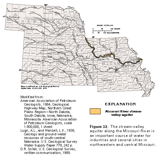
Alluvial deposits along the Missouri River form an important stream-valley aquifer from the Iowa-Missouri State line to the junction of the Missouri and the Mississippi Rivers (fig. 32); small areas of similar deposits in eastern Nebraska compose local aquifers. The deposits partly fill an entrenched bedrock valley that ranges from about 2 to 10 miles wide. In many places in northern Missouri, the bedrock contains slightly saline to saline water, and the stream-valley aquifers, along with aquifers in glacial drift, are the only sources of fresh ground water. The part of the stream-valley aquifer along the Missouri River between St. Charles and Jefferson City, Missouri (area D9 in fig. 19) is described below.
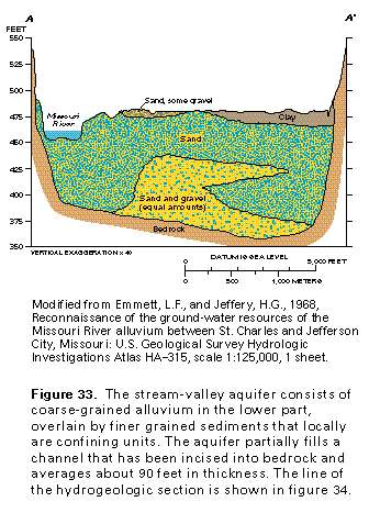
The stream-valley aquifer consists of clay, silt, sand, and gravel. Gravel and sand generally are most common in the lower parts of the aquifer (fig. 33). Poorly permeable silt and clay are prominent in the upper part of the aquifer and locally create confined conditions. Sandstone, limestone, dolomite, and shale of Pennsylvanian and Mississippian age mostly compose the bedrock that underlies the stream-valley aquifer in western Missouri. From the Howard-Boone County line eastward, the bedrock consists of Ordovician limestone and dolomite. In upland areas, glacial deposits overlie the bedrock and locally are hydraulically connected to the stream-valley aquifer.
The alluvial material of the stream-valley aquifer averages about 90 feet in thickness but is locally as much as 160 feet thick. The saturated thickness of the aquifer averages about 80 feet. Reported yields of wells completed in the aquifer range from less than 100 to about 3,000 gallons per minute.
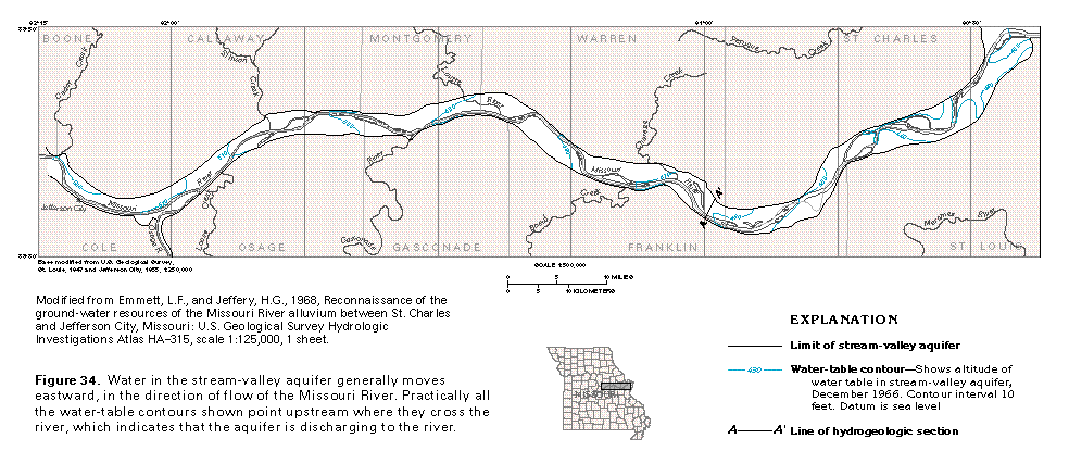
Recharge to the stream-valley aquifer is by infiltration of precipitation, seepage of water from the Missouri River to the aquifer during periods of high streamflow, and inflow from bedrock aquifers. Discharge from the aquifer is by evapotranspiration, withdrawals by wells, and seepage to the Missouri River during periods of low streamflow. The general direction of water movement in the stream-valley aquifer is downstream and toward the river (fig. 34).
Water in the stream-valley aquifer is a calcium bicarbonate type and is characterized by excessive iron content and hardness; in many places, the water is softened before use. Dissolved-solids concentrations in water from the aquifer range from about 250 to 1,500 milligrams per liter and are largest in areas where saline water leaks upward from bedrock and is diluted by mixing with freshwater.
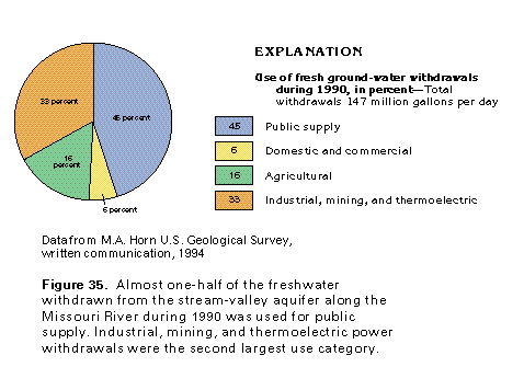
During 1990, an average of about 147 million gallons of water per day was withdrawn from the stream-valley aquifer (fig. 35). About 45 percent of this amount, or about 66 million gallons per day, was used for public supply. Industrial, mining, and thermoelectric power withdrawals amounted to about 48 million gallons per day, and agricultural withdrawals were about 24 million gallons per day. The remainder of the water withdrawn (about 9 million gallons per day) was used for domestic and commercial purposes.
MISSISSIPPI RIVER VALLEY ALLUVIAL AQUIFER
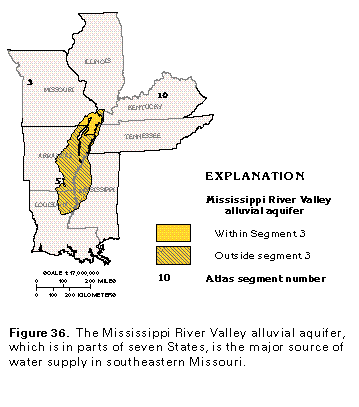
Alluvial material adjacent to the Mississippi River forms an important aquifer in the northern part of the Mississippi Embayment. This aquifer, which is called the Mississippi River Valley alluvial aquifer, is in parts of Arkansas, Illinois, Kentucky, Louisiana, Mississippi, Missouri, and Tennessee (fig. 36). It is most extensive, and is described in more detail, in Segment 5 of this Atlas. The part of the aquifer that is located in the bootheel of Missouri is the principal source of irrigation water there.
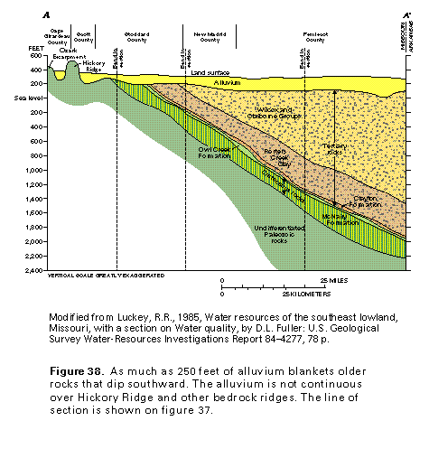
The Mississippi River Valley alluvial aquifer in Missouri consists of sand and gravel with minor amounts of silt and clay. The alluvium that composes the aquifer was deposited by the ancestral Mississippi and Ohio Rivers during Quaternary time and is bounded to the north by Paleozoic rocks that are exposed along the Ozark Escarpment (fig. 37). The thickness of the alluvium ranges from a featheredge along the escarpment to more than 250 feet locally near the Mississippi River and generally increases southward and southeastward (fig. 37 and fig. 38). The thickest areas probably represent infilling of ancient stream channels. The alluvium is thin or absent from Crowleys Ridge, Hickory Ridge, and the Benton Hills. These ridges and hills rise as much as 250 feet above the surface of the surrounding alluvial plain and are underlain by rocks of early Tertiary, Cretaceous, and Paleozoic age.
The coarse-grained sediments of the Mississippi River Valley alluvial aquifer are highly permeable. Wells completed in the aquifer will yield 1,000 gallons per minute in most places, and, locally, yields of 3,000 gallons per minute have been reported. Well depths commonly are 100 feet or less. Transmissivity values for the alluvial aquifer, which were calculated from aquifer test data, range from 15,000 to 54,000 square feet per day and average about 40,000 square feet per day. This productive aquifer is the major source of water for the intense agricultural development in the area.
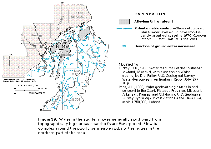
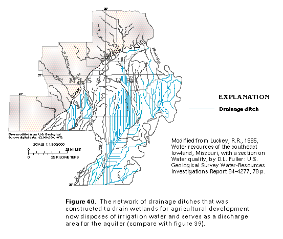
The water in the Mississippi River Valley alluvial aquifer is mostly unconfined and water levels rise rapidly in response to rainfall. Near major streams, aquifer water levels rise and fall in response to changes in stream water levels. Water in the aquifer moves generally southward from topographically high areas near the Ozark Escarpment (fig. 39). Local high areas on the potentiometric surface represent sandy ridges where the aquifer receives larger amounts of recharge. The poorly permeable rocks that underlie Crowleys Ridge and the Benton Hills form local barriers to ground-water flow. An extensive network of agricultural drainage ditches (fig. 40) has been constructed, and the aquifer discharges to these ditches and to major streams.
The chemical quality of the water in the Mississippi River Valley alluvial aquifer generally meets the standards recom-mended for public water supplies by the U.S. Environmental Protection Agency; locally, excessive concentrations of iron and manganese have been reported. Iron concentrations in water from the aquifer locally are as much as 35 milligrams per liter and average about 4.3 milligrams per liter; manganese concentrations locally are as much as 2.0 milligrams per liter and average 0.46 milligram per liter. The water is a calcium-magnesium bicarbonate type, generally hard, and has small dissolved-solids concentrations (averaging 240 milligrams per liter). Locally, the water in the aquifer contains traces of pesticides and nutrients as a result of downward leakance of irrigation water from fields that have been treated with chemicals for insect control or with fertilizer.
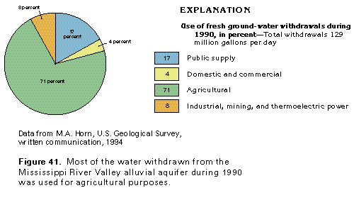
Withdrawals of freshwater from the Mississippi River Valley alluvial aquifer totaled 129 million gallons per day during 1990 (fig. 41). About 92 million gallons per day was withdrawn for agricultural purposes, which is the principal water use. About 22 million gallons per day was withdrawn for public supply, and about 10 million gallons per day was pumped for industrial, mining, and thermoelectric power uses. Withdrawals for domestic and commercial uses were about 5 million gallons per day.
GLACIAL-DRIFT AQUIFERS
The maximum southern extent of glacial ice and glacial-drift deposits was about the present location of the Missouri River in Missouri and just south of the Kansas River in northeastern Kansas. The glacial deposits in Segment 3 are pre-Illinoian and, thus, are older than deposits in States to the north and east of the segment. Some of the drift in Segment 3 might be of late Pliocene age, whereas most glacial deposits in North America are considered to be Pleistocene. Although deposits of glacial drift extend over wide areas, most were laid down directly by the ice; are fine grained, poorly sorted, or both; and, therefore, yield only small amounts of water to wells.
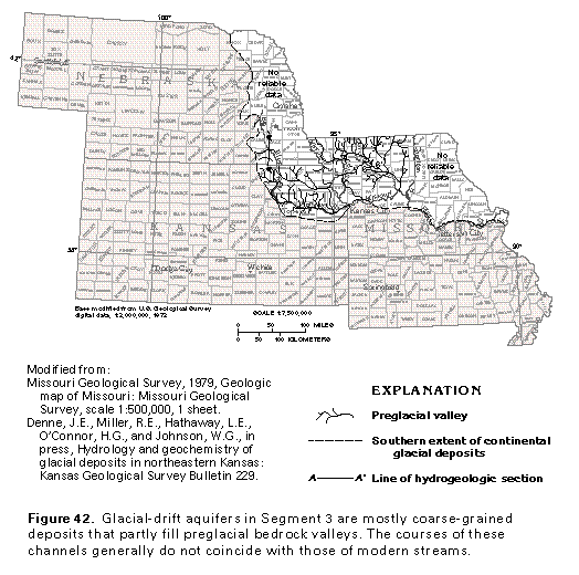
The thickness of glacial drift generally is 100 to 200 feet but locally is greater than 300 feet in eastern Missouri and 400 feet in western Missouri and northeastern Kansas. In southeastern Nebraska, local drift thicknesses of more than 350 feet have been reported. Meltwater created an extensive stream network in front of the advancing ice (fig. 42), and the streams deposited gravel, sand, and finer sediments as alluvium along the courses of preglacial bedrock valleys.
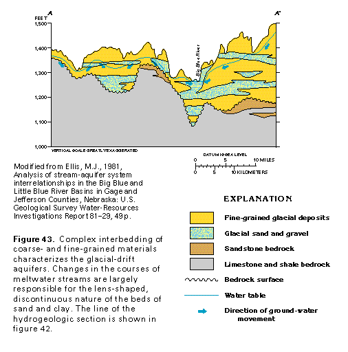
Complex interbedding of fine- and coarse-grained material is characteristic of the glacial deposits (fig. 43). The lenslike shape of some of the beds is the result of meandering of the meltwater streams across their valley floors and of periodic changes in stream-channel locations. However, in parts of Missouri, the glacial-drift aquifers are not complexly interbedded. For example, in the Grand River Valley of Daviess County, Missouri, the basal part of the deposits that fill glacial stream channels is coarse grained, and the upper part generally consists of poorly permeable silt, clay, or till (fig. 44). Such aquifers are called buried channel or buried valley aquifers and contain water under confined or semiconfined conditions. Not all the drift consists of sand and gravel, (shown in figures 43 and 44), and not all is saturated. Water generally is obtained from sand beds that range from 20 to 40 feet in thickness.
Yields of wells completed in the glacial-drift aquifers are highly variable and range from less than 10 to about 1,000 gallons per minute. Large diameter wells that penetrate several thick, saturated, highly permeable sand beds yield the most water. Even in places where wells penetrate only one thin sand bed in the glacial-drift deposits, yields are generally larger than those of wells completed in the underlying bedrock. Transmissivity values that range from 200 to 13,000 feet squared per day have been reported from aquifer tests in glacial-drift aquifers in Kansas. The larger transmissivity values represent places where several thick sand beds were encountered by wells; the smaller values indicate that thin sand beds with low permeability were penetrated.
Movement of water in the glacial-drift aquifers is from recharge areas to discharge areas along major modern streams. Much of the water moves along short flow paths to the nearest surface-water body, where it discharges. Some water follows longer flow paths and discharges to regional drains. A small amount of the water percolates downward and enters un-derlying bedrock aquifers.
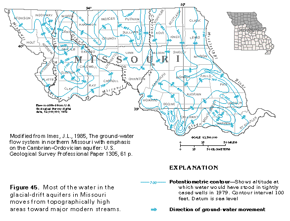
The complex interbedding of permeable and poorly permeable sediments in the glacial- drift aquifers results in a large number of local confining units. Accordingly, water in these aquifers is under unconfined conditions in some places and confined conditions in other places. Where several sand and clay beds are stacked, water levels in each of the stacked sand beds may be different. The potentiometric surface of the glacial-drift aquifers is, therefore, a composite surface and shows only the general configuration of water levels. The influence of topography on water levels in these aquifers is shown by a map of their potentiometric surface in Missouri (fig. 45). Topographically high areas in Clinton and Sullivan Counties, for example, stand out clearly. The low water levels parallel to the courses of the Missouri and the Mississippi Rivers and some of their tributaries show that the aquifer discharges water to these streams.
The chemical quality of the water in the glacial-drift aquifers generally is suitable for most uses. The water is hard and commonly is a calcium bicarbonate type although in many places in Missouri and locally in Kansas, it is a sodium sulfate type. Dissolved-solids concentrations in water from these aquifers usually are less than 500 milligrams per liter but exceed 3,900 milligrams per liter in places. Sulfate concentrations ordinarily are 250 milligrams per liter or less except locally in Kansas and in Missouri; concentrations of sulfate as great as 2,150 milligrams per liter have been reported in Missouri. The source of the sulfate is dissolution of gypsum in the underlying bedrock in areas where the hydraulic head in the bedrock is greater than that in the glacial-drift aquifers; this condition allows the high-sulfate water to leak upward. Locally, concentrations of as much as 30 milligrams per liter of iron have been reported in Missouri. Nitrate concentrations that are greater than 45 milligrams per liter have been reported in water from these aquifers in Kansas, which probably reflects local contamination from agricultural sources or human wastes.