GROUND WATER ATLAS of the UNITED STATES
Oklahoma, Texas
HA 730-E
Coastal lowlands aquifer system
There are two different files for each illustration
- A 72 ppi GIF file, suitable for screen viewing is accessed through
the thumbnail image
- An eps file, suitable for downloading to be printed or edited is accessed
through the "eps file" link. Most files are Adobe Illustrator
6.0, exceptions are noted. These files have been compressed with GNU's
gzip utility. If your web browser defaults to a screen display of the file,
turn on the "Load to local disk" option before downloading. Download
and process these eps files as ascii, not binary.
Potential for development
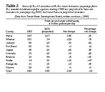
Table 2 Table listing the projected pumpage increase from 1985 to
2030 (17K)
 editable eps file Etab2.eps.gz
(17K compressed)
editable eps file Etab2.eps.gz
(17K compressed)
 editable eps file Etab2.eps.gz
(17K compressed)
editable eps file Etab2.eps.gz
(17K compressed)