GROUND WATER ATLAS of the UNITED STATES
Oklahoma, Texas
HA 730-E
Rio Grande aquifer system
There are two different files for each illustration
- A 72 ppi GIF file, suitable for screen viewing is accessed through
the thumbnail image
- An eps file, suitable for downloading to be printed or edited is accessed
through the "eps file" link. Most files are Adobe Illustrator
6.0, exceptions are noted. These files have been compressed with GNU's
gzip utility. If your web browser defaults to a screen display of the file,
turn on the "Load to local disk" option before downloading. Download
and process these eps files as ascii, not binary.
Hueco Basin
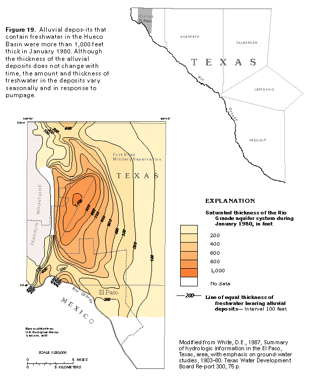
Figure 19 Map showing alluvial deposits that contain freshwater in
the Hueco Basin (33K)
 editable eps file E019.eps.gz
(50K compressed)
editable eps file E019.eps.gz
(50K compressed)
Figure 20 Photo of the northeastern part of the city of El
Paso (50K)
 This illustration contains a placed image. Download the Adobe Illustrator
6 eps file E020.eps.gz (5.3M compressed)
which contains an imbedded Adobe Photoshop 3 (eps) file. You may also want
to download the editable Photoshop
file E020psh.eps.gz (5.3M compressed)
This illustration contains a placed image. Download the Adobe Illustrator
6 eps file E020.eps.gz (5.3M compressed)
which contains an imbedded Adobe Photoshop 3 (eps) file. You may also want
to download the editable Photoshop
file E020psh.eps.gz (5.3M compressed)
Figure 21 Map showing net water-level decline in the Hueco
Basin alluvial aquifer (33K)
 editable eps file E021.eps.gz
(33K compressed)
editable eps file E021.eps.gz
(33K compressed)
Figure 22 Map and cross section showing the change in dissolved
solids concentration (33K)
 editable eps file E022.eps.gz
(66K compressed)
editable eps file E022.eps.gz
(66K compressed)
 editable eps file E019.eps.gz
(50K compressed)
editable eps file E019.eps.gz
(50K compressed) 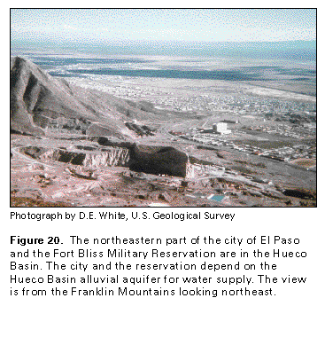 This illustration contains a placed image. Download the Adobe Illustrator
6 eps file E020.eps.gz (5.3M compressed)
which contains an imbedded Adobe Photoshop 3 (eps) file. You may also want
to download the editable Photoshop
file E020psh.eps.gz (5.3M compressed)
This illustration contains a placed image. Download the Adobe Illustrator
6 eps file E020.eps.gz (5.3M compressed)
which contains an imbedded Adobe Photoshop 3 (eps) file. You may also want
to download the editable Photoshop
file E020psh.eps.gz (5.3M compressed) 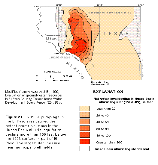 editable eps file E021.eps.gz
(33K compressed)
editable eps file E021.eps.gz
(33K compressed) 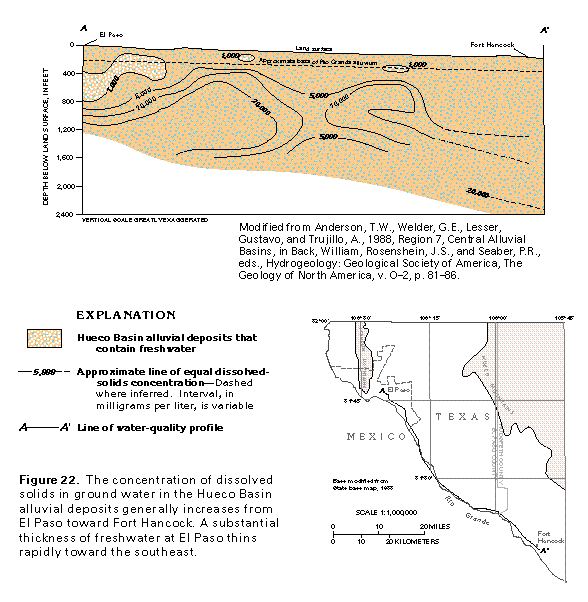 editable eps file E022.eps.gz
(66K compressed)
editable eps file E022.eps.gz
(66K compressed)