REGIONAL SUMMARY
INTRODUCTION
The two States, Oklahoma and Texas, that compose Segment 4 of this Atlas are located in the south-central part of the Nation. These States are drained by numerous rivers and streams, the largest being the Arkansas, the Canadian, the Red, the Sabine, the Trinity, the Brazos, the Colorado, and the Pecos Rivers and the Rio Grande. Many of these rivers and their tributaries supply large amounts of water for human use, mostly in the eastern parts of the two States. The large perennial streams in the east with their many associated impoundments coincide with areas that have dense populations. Large metropolitan areas such as Oklahoma City and Tulsa, Okla., and Dallas, Fort Worth, Houston, and Austin, Tex., are supplied largely or entirely by surface water. However, in 1985 more than 7.5 million people, or about 42 percent of the population of the two States, depended on ground water as a source of water supply. The metropolitan areas of San Antonio and El Paso, Tex., and numerous smaller communities depend largely or entirely on ground water for their source of supply. The ground water is contained in aquifers that consist of unconsolidated deposits and consolidated sedimentary rocks. This chapter describes the geology and hydrology of each of the principal aquifers throughout the two-State area.
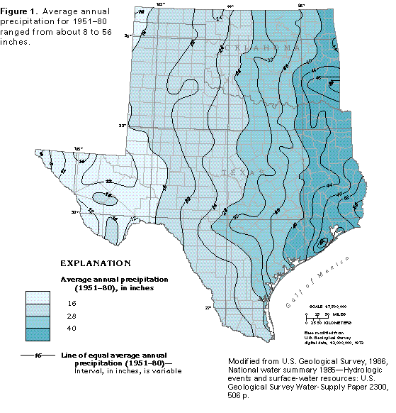
Precipitation is the source of all the water in Oklahoma and Texas. Average annual precipitation ranges from about 8 inches per year in southwestern Texas to about 56 inches per year in southeastern Texas (fig. 1). In general, precipitation increases rather uniformly from west to east in the two States.
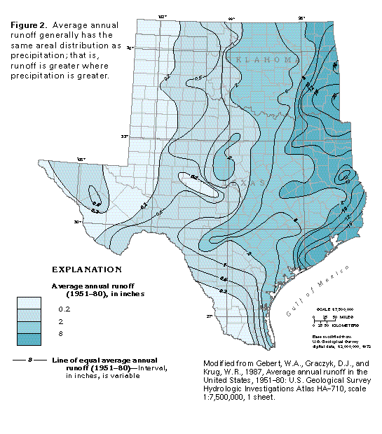
Much of the precipitation either flows directly into rivers and streams as overland runoff or indirectly as base flow that discharges from aquifers where the water has been stored for some time. Accordingly, the areal distribution of average annual runoff from 1951 to 1980 (fig. 2) reflects that of average annual precipitation. Average annual runoff in the two-State area ranges from about 0.2 inch in the western part of the Oklahoma panhandle and parts of west Texas to about 20 inches in southeastern Oklahoma.
Comparison of the precipitation and runoff maps shows that runoff is greater where precipitation is greater. However, precipitation is greater than runoff everywhere in the two-State area. Much of the precipitation that falls on the area is returned to the atmosphere by evapotranspiration, which is the combination of evaporation from surface-water bodies, such as lakes and marshes, and transpiration from plants. Part of the precipitation percolates downward through the soil and permeable rocks and is available for aquifer recharge throughout the area.
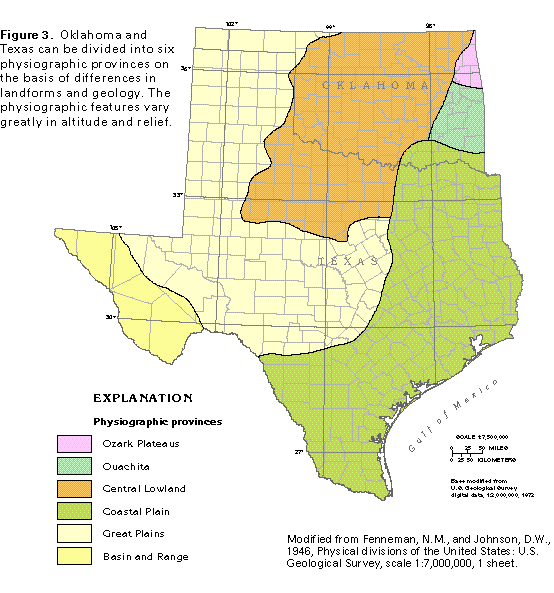
Oklahoma and Texas lie within six major physiographic provinces which are differentiated on the basis of differences in landforms and geology (fig. 3). The physiographic features vary greatly and range from the low, flat Coastal Plain Province through the high, gently rolling High Plains Province to mountain ranges in the Ouachita and the Basin and Range Provinces.
MAJOR AQUIFERS
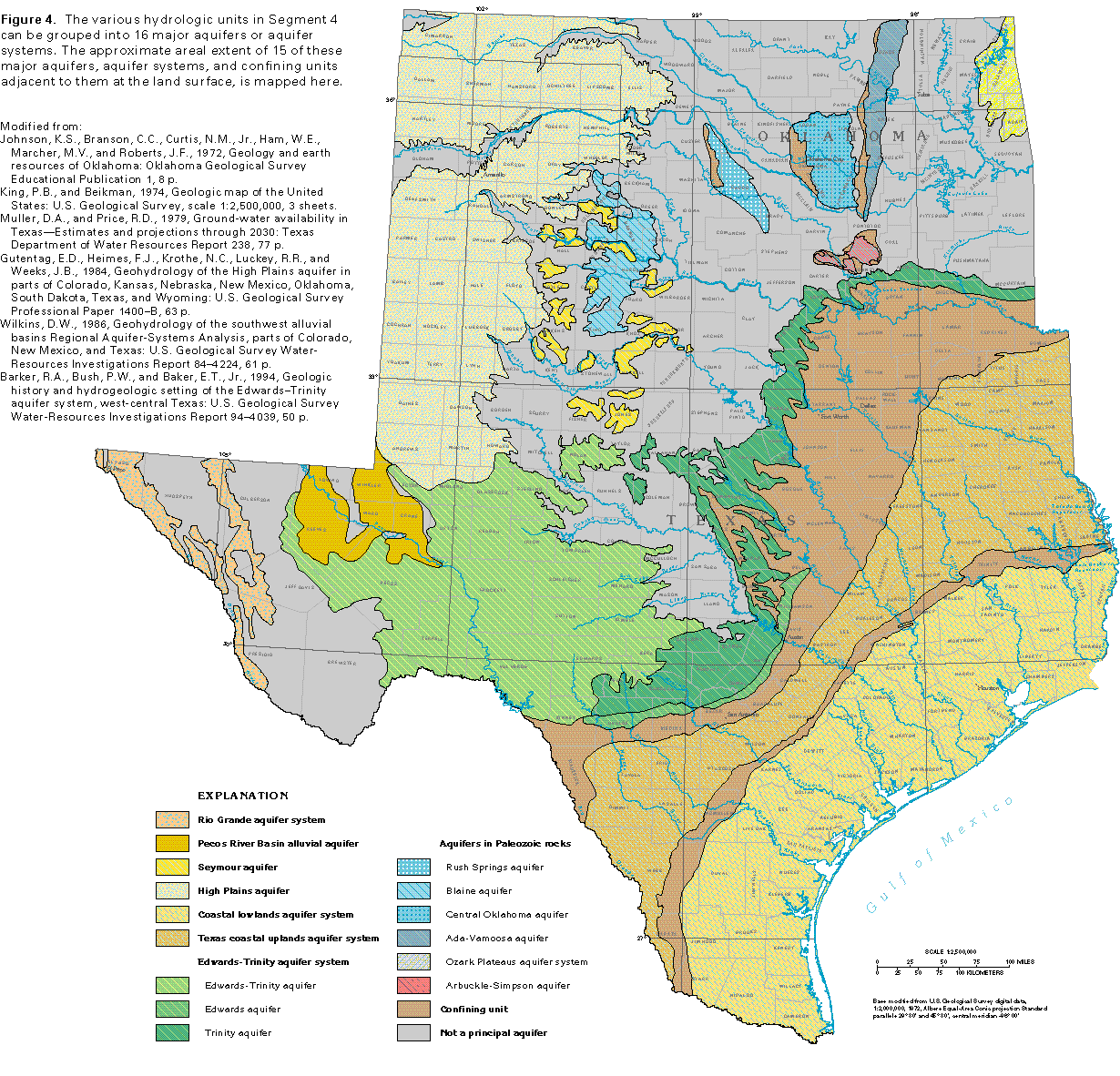
The numerous aquifers in Oklahoma and Texas are in geologic units that range from unconsolidated sand along major streams to consolidated carbonate rocks and sandstones that extend over wide areas. These aquifers are grouped into 16 major aquifers or aquifer systems on the basis of differences in their rock types and ground-water flow systems. An aquifer system is a grouping of two or more aquifers and can be of two types. One type consists of vertically stacked aquifers that are separated by confining units but are hydraulically connected-that is, their flow systems function in a similar manner, and a change in conditions in one aquifer affects the other aquifer(s). The second type is a set of aquifers that are not physically connected but share common geologic and hydrologic characteristics and can thus be studied and described together. Both types of aquifer systems are in Segment 4.
The approximate areal extent of 15 of the major aquifers or aquifer systems at the land surface is shown in figure 4: the 16th category, alluvial aquifers along major streams, is not shown in the figure. Where they are exposed at the land surface, the aquifers generally contain water that is fresh to slightly saline. The aquifers in this chapter generally are mapped only where they contain fresh to moderately saline water, except where physical boundaries determine the aquifer limits. Salinity in this report refers to the concentration of dissolved solids in water, which commonly is used as an indicator of the general suitability of the water for human use. Recommendations by the U.S. Environmental Protection Agency state that the dissolved-solids concentration in drinking water should not exceed 500 milligrams per liter. Water that has considerably greater concentrations can be suitable for other uses.
The terms used in this report to describe water with different concentrations of dissolved solids are as follows:
Dissolved-solids concentration, in milligrams per liter
| Freshwater | Less than 1,000 |
| Slightly saline water | 1,000 to 3,000 |
| Moderately saline water | 3,000 to 10,000 |
| Very saline water | 10,000 to 35,000 |
| Brine | Greater than 35,000 |
The general term saline is used to describe water that is not fresh.
In some areas, a deep aquifer that contains fresh to slightly saline water underlies the outcrop of a major aquifer mapped here, For example, parts of the Edwards-Trinity aquifer are covered by the Pecos River Basin alluvial aquifer in northern Reeves and Pecos Counties, Tex. and by the High Plains aquifer in northern Ector, Midland, and Glasscock Counties, Tex. In addition, in some areas, alluvial aquifers along large streams cover small areas of underlying major aquifers. The rocks not classified as a major aquifer either yield little water or yield sufficient water for most uses but the areal extent of the water-yielding rocks is small.
Alluvial aquifers, which are discussed later in this chapter, are along major streams in Oklahoma and Texas. These aquifers consist of deposits of alluvium in and along stream channels, alluvial terraces that are remnants of older alluvium, and overlying windblown deposits. The deposits consist of clay, silt, sand, and gravel; only the sand and gravel yield water. The deposits range in age from Tertiary to Quaternary and are a few feet to more than 100 feet thick. The alluvial aquifers generally contain water under unconfined conditions.
The Rio Grande aquifer system in westernmost Texas is in the Basin and Range Physiographic Province (fig. 3). The aquifer system consists of thick deposits of unconsolidated basin-fill material, which is mostly sand but may include a variety of rock types and particle sizes that range from clay to boulders.
The Pecos River Basin alluvial aquifer is in the Great Plains Physiographic Province. The aquifer consists of unconsolidated sand and gravel, some of which was deposited by streams and some by wind. The deposits locally include clay, silt, and boulders. Small amounts of gypsum and caliche, which are formed by chemical processes, are in the Pecos River Basin alluvial aquifer. The Seymour aquifer is in the Great Plains and Central Lowland Physiographic Provinces. The aquifer consistsmainly of scattered erosional remnants of the alluvial Seymour Formation of Pleistocene age. Saturated thickness of the scattered alluvial deposits is generally less than 100 feet, but large well yields are locally obtainable. The water is used mainly for agricultural purposes.
The High Plains aquifer is in the Great Plains Physiographic Province. The aquifer is in northwestern Oklahoma and west-central and northwestern Texas and consists of unconsolidated clay, silt, and sand, with some gravel and caliche. The aquifer provides large amounts of irrigation water and is the most intensively pumped aquifer in Oklahoma and Texas.
The coastal lowlands aquifer system contains numerous local aquifers in a thick sequence of mostly unconsolidated Coastal Plain sediments of alternating and interfingering beds of clay, silt, sand, and gravel. The sequence is generally wedge-shaped and dips and thickens toward the Gulf of Mexico. The local aquifers consist of sand and gravel and have been grouped into five permeable zones of regional extent. Large amounts of water are withdrawn from the aquifer system for municipal, industrial, and irrigation needs.
The Texas coastal uplands aquifer system is similar in configuration and composition to the coastal lowlands aquifer system. The two aquifer systems, which are situated in the Coastal Plain Physiographic Province, are hydraulically separated by clays of the Vicksburg and the Jackson Groups of Tertiary age, which compose a thick and effective confining unit. Large amounts of irrigation water are withdrawn from the Texas coastal uplands aquifer system in the agricultural Winter Garden area of Texas.
The Edwards-Trinity aquifer system is in rocks of Cretaceous age that are in a wide, looping band that extends across central Texas and into the southeastern corner of Oklahoma. The aquifer system is divided into three parts. In the western part of the Great Plains Physiographic Province, the Edwards-Trinity aquifer consists mostly of sandstone, sand, dolomite, and clay of Early Cretaceous age. In the south, at the contact of the Great Plains and the Coastal Plain Physiographic Provinces, the Edwards aquifer consists of limestone, dolomite, and marl. The rocks are extensively faulted, fractured, and cavernous, thus allowing the largest individual freshwater well yields in Texas and Oklahoma. The Edwards aquifer is the water supply for the city of San Antonio. The Trinity aquifer extends from the southeastern corner of Oklahoma southwestward into Uvalde County in southern Texas. The aquifer spans three physiographic provinces-the Central Lowland, the Coastal Plain, and the Great Plains. The rocks that compose the aquifer are mostly of Early Cretaceous age. In order of dominance, they consist of sandstone, sand, clay, conglomerate, caliche, shale, limestone, and dolomite.
Several aquifers and one aquifer system in Oklahoma and northern Texas are in Paleozoic rocks; generally, they yield small amounts of water to wells. The Rush Springs aquifer in west-central Oklahoma consists of fine-grained sandstone and is used primarily for irrigation. The Blaine aquifer in southwestern Oklahoma and northern Texas consists of fractured and cavernous gypsum and associated dolomite, and supplies water for irrigation. The Central Oklahoma aquifer consists of fine-grained sandstone, shale, and siltstone; it is an important source of water for suburban communities in the Oklahoma City area. The Ada-Vamoosa aquifer in east-central Oklahoma consists of sandstone and provides water for public and industrial use. The Rush Springs, the Blaine, the Central Oklahoma, and the Ada-Vamoosa aquifers are in the Central Lowland Physiographic Province. The Arbuckle-Simpson aquifer in south-central Oklahoma is in the Central Lowland Physiographic Province and consists of limestone, dolomite, and sandstone. The Ozark Plateaus aquifer system in northeastern Oklahoma is in the Ozark Plateaus Physiographic Province and consists of an upper aquifer in cavernous limestone and a lower aquifer in fractured dolomite with sandy zones.
GEOLOGY
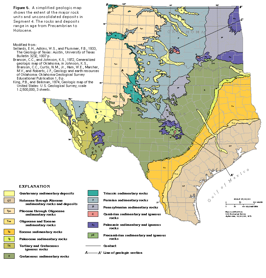
Two general categories of sedimentary rocks comprise most of the rocks that underlie Oklahoma and Texas-mostly consolidated rocks of Paleozoic and Mesozoic age, and semi-consolidated to unconsolidated rocks of Cenozoic age. The Paleozoic (Cambrian through Permian) and Mesozoic (Triassic through Cretaceous) sedimentary rocks crop out mostly in Oklahoma and northern, central, and westernmost Texas. Cenozoic (Paleocene and younger) rocks underlie the Great Plains in the northwestern parts of Texas and Oklahoma; they also underlie the Coastal Plain where they form a broad, arcuate, coast-parallel band. Both categories of rocks have been divided into numerous formations, as shown on the correlation charts that accompany the discussions of the major aquifers in the following sections of this chapter.
The majority of the water-yielding Paleozoic and Mesozoic rocks are limestone and dolomite; however, sandstone formations are productive aquifers, especially in Oklahoma, and some water also is obtained locally from fractured shale, siltstone, and gypsum. Most Cenozoic aquifers are in clastic rocks.
The geologic and hydrogeologic nomenclature used in this report differs from State to State because of independent geologic interpretations and varied distribution and lithology of rock units. A fairly consistent set of nomenclature, however, can be derived from the most commonly used rock names. Therefore, the nomenclature used in this report is basically a synthesis of that of the U.S. Geological Survey, the Texas Bureau of Economic Geology, and the Oklahoma Geological Survey. Individual sources for nomenclature are identified on the figures prepared for this report.
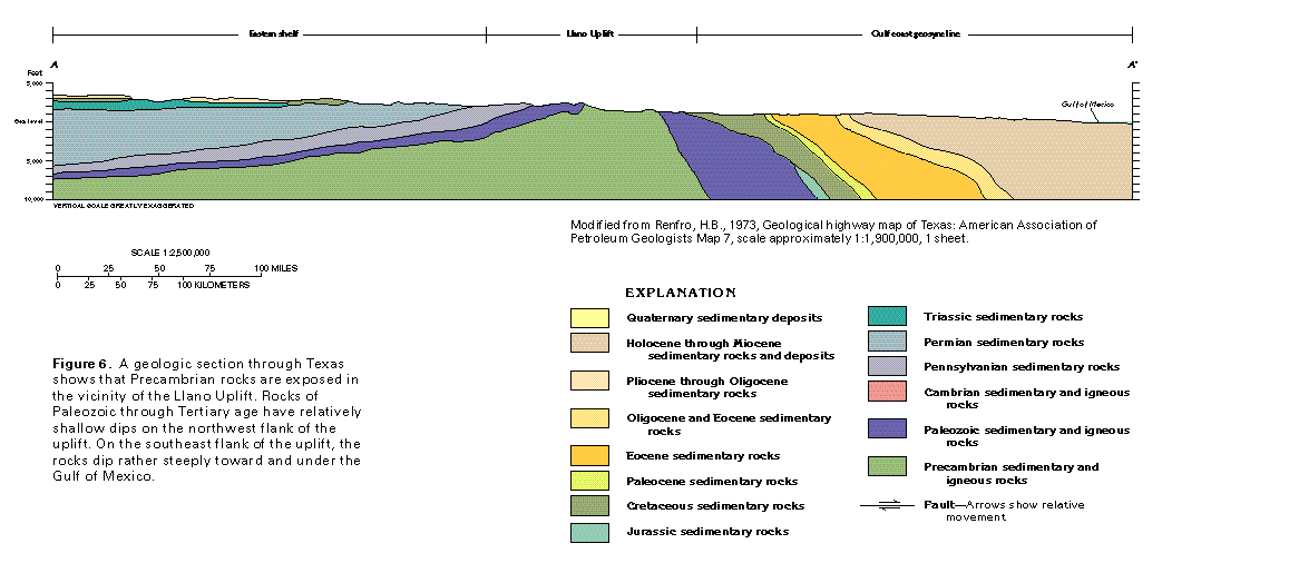
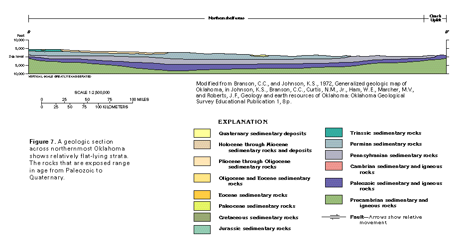
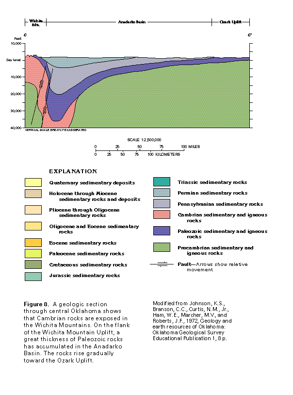
The geologic map (fig. 5) shows the distribution of rocks by major age category. Numerous geologic features, such as faults and lineaments, are not shown on the geologic map for the sake of simplicity. Where these features are important hydrologically, they will be depicted and discussed in later sections of this chapter. The geologic sections (figs. 6, 7, and 8) show some of the major subsurface structures in Oklahoma and Texas.
FRESH GROUND-WATER WITHDRAWALS
Ground water is the source of water supply for more than 7.5 million people, or about 42 percent of the population in the two-State area. About 7,300 million gallons per day was withdrawn from all the principal aquifers during 1985; 80 percent of this amount was used in rural areas for agricultural, domestic, and commercial supplies. Withdrawals for public supplies were small and accounted for only about 16 percent of the total water withdrawn.
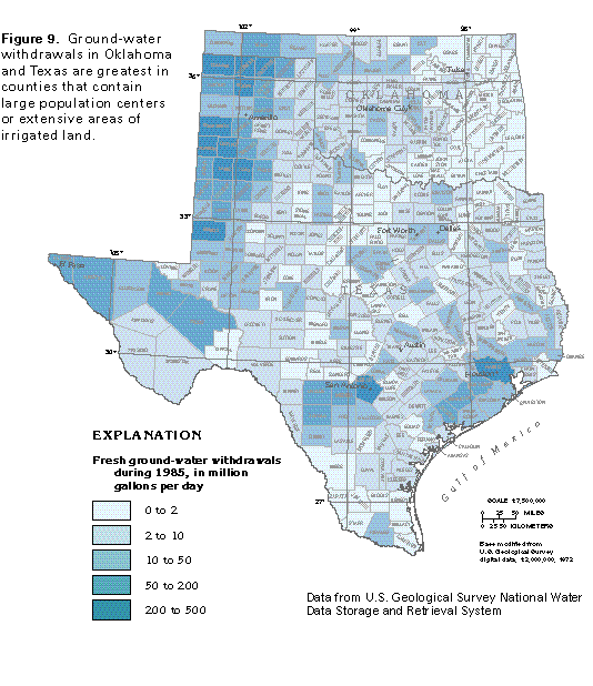
Total freshwater withdrawals during 1985, by county, are shown in figure 9. Counties with the largest withdrawals are those with large irrigated acreage and large population centers. About 94 percent of the ground water was withdrawn in Texas, and the remainder was withdrawn in Oklahoma. Locally, slightly saline ground-water withdrawals are included in the mapped amounts.
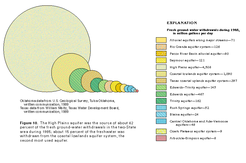
Total withdrawals of freshwater (including slightly saline water) during 1985 from each of the principal aquifers in the two-State area are shown in figure 10. The largest withdrawal, 4,508 million gallons per day, was from the High Plains aquifer; this is about four times as much water as was withdrawn from the second most used aquifer, the coastal lowlands aquifer system (1,090 million gallons per day), and more than 2.5 times as much water as was withdrawn from all the other principal aquifers combined. The Edwards aquifer was the third most used aquifer with a withdrawal rate of 467 million gallons per day; more than one-half was withdrawn in Bexar County, Tex., where ground water is the source of water supply for the city of San Antonio.
About 397 million gallons per day was withdrawn from the Texas coastal uplands aquifer system, the fourth most used aquifer, during 1985. During the same year, the Trinity aquifer provided 182 million gallons per day, and 145 million gallons per day was withdrawn from the Edwards-Trinity aquifer. Withdrawals from the Rio Grande aquifer system and the Seymour aquifer during 1985 were 126 and 121 million gallons per day, respectively. The Pecos River Basin alluvial aquifer and the alluvial aquifers along major streams accounted for withdrawals of 80 and 71 million gallons per day, respectively, during 1985. Withdrawals from the mostly indurated aquifers in Paleozoic rocks in Oklahoma and northern Texas were small; during 1985, the Rush Springs, the Central Oklahoma and the Ada-Vamoosa, the Blaine, the Ozark Plateaus, and the Arbuckle-Simpson aquifers accounted for 52, 48, 24, 9, and 8 million gallons per day, respectively.