PECOS RIVER BASIN ALLUVIAL AQUIFER
INTRODUCTION
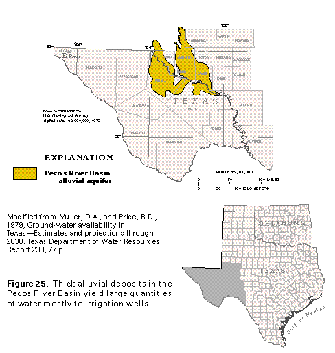
Thick and extensive alluvial deposits of Cenozoic age compose the Pecos River Basin alluvial aquifer in western Texas (fig. 25). The aquifer is in the Great Plains Physiographic Province and underlies approximately 5,000 square miles in parts of Andrews, Crane, Ector, Loving, Pecos, Reeves, Ward, and Winkler Counties. The topography in the area consists mostly of flat to rolling plains that slope gently toward the Pecos River. Ground water in the Cenozoic alluvium is of major importance in this area where average annual rainfall is less than 12 inches.
HYDROGEOLOGY
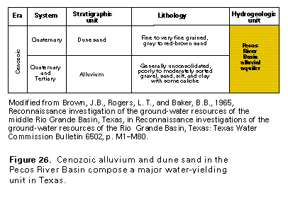
During late Tertiary and Quaternary time, streams that flowed across the area laid down thick, extensive deposits of alluvium. Prevailing winds subsequently deposited a cover of sand in the eastern part of the area. The alluvial deposits, in order of abundance, consist of gravel, sand, silt, and clay; the deposits contain some caliche (fig. 26). The alluvium generally ranges from 100 to 300 feet in thickness; in places, it is as much as 1,500 feet thick.
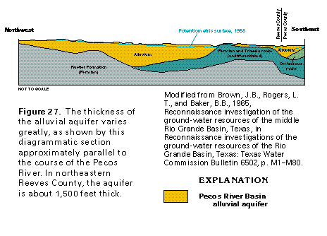
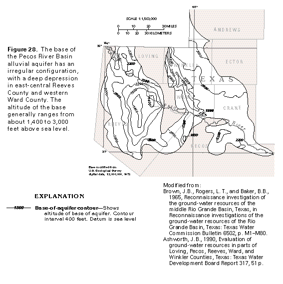
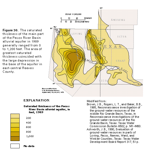
The alluvium overlies Permian, Triassic, and Cretaceous rocks as shown by a diagrammatic section that extends from northern Reeves County to northern Pecos County approximately parallel to the Pecos River (fig. 27). In places, these underlying rocks can yield substantial quantities of water and may be in hydraulic connection with the overlying alluvium. The maximum thickness of the alluvium in the section is about 1,500 feet in northeastern Reeves County near the Pecos River. Dissolution of evaporites in underlying Permian rocks has resulted in subsidence and the formation of deep troughs in Reeves County and in Winkler and Ward Counties; thick deposits of Cenozoic alluvium have accumulated in the troughs, which are evident in the base-of-aquifer map shown in figure 28. The altitude of the base ranges from less than 1,400 feet to more than 3,000 feet above sea level.
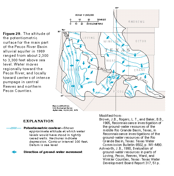
Water in the alluvium is generally unconfined; however, confined conditions prevail in local areas where a clay confining unit is present. Under natural conditions, ground water generally moves from recharge areas near the margins of the alluvium toward the Pecos River. However, pumpage for irrigation in such areas as central Reeves and northern Pecos Counties has caused hydraulic gradients to reverse; consequently, water moves toward these areas from all directions (fig. 29). The saturated thickness of the aquifer, based on the altitude of the 1989 potentiometric surface, ranged from 0 to more than 1,000 feet (fig. 30).
Recharge to the alluvium is by direct precipitation, infiltration from intermittent streamflow, return irrigation water, and subsurface flow from older formations. Recharge by precipitation is especially effective in an area that is covered with sand dunes and extends from southwestern Andrews County through parts of Winkler, Ector, and Ward Counties into central Crane County.
The natural concentration of dissolved solids in water in the alluvial aquifer commonly exceeds 1,000 milligrams per liter. The salinity, which has increased substantially in some areas of intense pumpage, is caused primarily by induced infiltration of highly mineralized water from the Pecos River and return flow of irrigation water that has high mineral content caused by concentration by evapotranspiration and leaching of salts and fertilizers from the soil.
Ground water in the alluvial aquifer is used principally for irrigation. Irrigation wells completed in the aquifer generally yield between 200 and 2,500 gallons per minute and average about 1,000 gallons per minute. Aquifer tests in Reeves, Pecos, Winkler, Ward, and Crane Counties show a large variability in the transmissivity of the alluvial aquifer, with values that range from 2,500 to 12,000 feet squared per day.
Annual pumpage from the alluvial aquifer is much greater than annual recharge. In an intensively irrigated area of central Reeves County, water levels declined more than 190 feet between 1951 and 1960.
Some of the area underlain by the alluvial aquifer is not suitable for irrigation from wells because either the terrain is too rough or the saturated thickness of the aquifer is not great enough to sustain well yields. In the areas that are suitable for ground-water withdrawal, more than 30 million acre-feet of fresh to slightly saline ground water is estimated to be in storage. If substantial water-quality degradation by migration of undesirable water is to be avoided, then only about 9.5 million acre-feet, or 32 percent, of this water can be pumped.
FRESH GROUND-WATER WITHDRAWALS
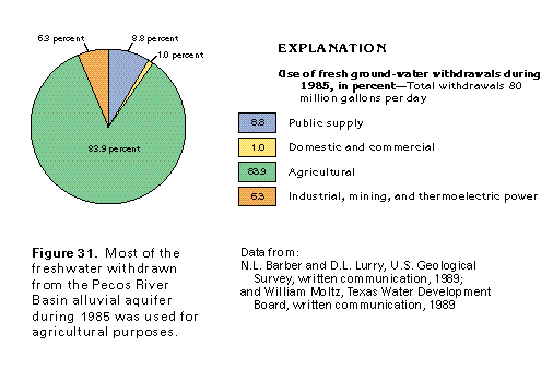
Withdrawals of freshwater from the Pecos River Basin alluvial aquifer totaled about 80 million gallons per day during 1985 (fig. 31). About 67 million gallons per day was withdrawn for agricultural purposes, the principal water use. Approximately 7 million gallons per day was withdrawn for public supply. About 5 million gallons per day was withdrawn for industrial, mining, and thermoelectric-power uses, and about 1 million gallons per day was withdrawn for domestic and commercial uses.