AQUIFERS IN PALEOZOIC ROCKS
INTRODUCTION
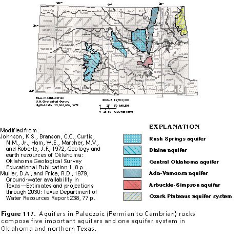
Five aquifers and one aquifer system in rocks of Paleozoic age-the Rush Springs, the Blaine, the Central Oklahoma, the Ada-Vamoosa, and the Arbuckle-Simpson aquifers and the Ozark Plateaus aquifer system-are in Oklahoma and part of northern Texas (fig. 117). The aquifers consist of sandstone, siltstone, shale, limestone, dolomite, and gypsum, either as a single rock type or in combination. The geologic formations in which the aquifers occur continue into the subsurface beyond the mapped aquifer boundaries, as shown in figure 118. Where the rocks that compose the aquifers have been tilted, permeability might be decreased or the dissolved-solids content of the water in the aquifers might become progressively greater in the deeper parts of the aquifers or both. Thus, the capacity of the rocks to yield substantial quantities of freshwater to wells commonly diminishes with depth, especially where confining units overlie the aquifers.
Precipitation is the source of nearly all water in the aquifers. Average annual precipitation ranges from about 20 inches in the western part of the area underlain by the Blaine aquifer to more than 40 inches in the area of the Ozark Plateaus aquifer system.
The greatest precipitation is generally in the spring months, but most recharge to the aquifers tends to be in the winter and early spring, when evaporation and transpiration are at a minimum. Little recharge takes place because neither the aquifers nor the overlying soils are highly permeable. An exception is in areas where sinkholes have been developed, such as in parts of the Ozark Plateaus aquifer system and the Blaine and the Arbuckle-Simpson aquifers.
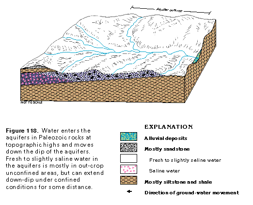
Ground-water levels are highest in the uplands between the streams. From these areas, ground water moves toward stream valleys where it is discharged by evapotranspiration, by spring discharge, or to streams as base flow. Fresh to slightly saline water in the aquifers is mostly under unconfined conditions in aquifer outcrop areas, but downdip the water is generally under confined conditions (fig. 118).
Because the permeability of the rocks that compose the aquifers is generally low, well yields are generally small. The aquifers are nevertheless important; the aggregate pumpage from them during 1985 was 141 million gallons per day.
Rush Springs Aquifer
The Rush Springs aquifer underlies an area of about 1,400 square miles in west-central Oklahoma. The area is in the Central Lowland Physiographic Province and includes parts of Blaine, Caddo, Comanche, Custer, Dewey, Grady, and Washita Counties. Average annual precipitation is about 26 to 30 inches. Agriculture is an important part of the economy of the area, and ground water for crop irrigation is an important resource.
HYDROGEOLOGY
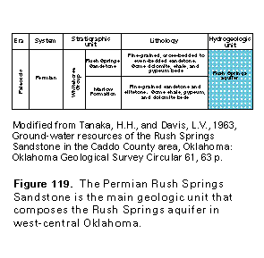
The Rush Springs aquifer consists of the Rush Springs Sandstone and the Marlow Formation, which are part of the Whitehorse Group of Permian age (fig. 119). The Rush Springs Sandstone, which is the main water-yielding unit, consists of fine-grained sandstone with some dolomite, shale, and gypsum beds. The formation has a maximum thickness of more than 300 feet in the south in Caddo County. In the western one-half of the area, the underlying Marlow Formation has a maximum thickness of about 125 feet and yields moderate amounts of water whose chemical quality is usable for most purposes.
Water in the Rush Springs aquifer is unconfined, except in deeper parts of the aquifer, where it is partly confined. The depth of the water table ranges from land surface to about 150 feet below land surface and is generally least in low-lying areas. Regional movement of ground water is generally southward and southeastward toward the Washita River. Well yields are commonly 200 to 600 gallons per minute, but yields of as much as 1,000 gallons per minute have been reported for some irrigation wells.
The aquifer generally yields water with a dissolved-solids concentration of less than 500 milligrams per liter in central Caddo, eastern Custer, and western Blaine Counties. In this area, sulfate and chloride concentrations are small, and the water is a calcium bicarbonate type. To the west and east, the water type changes to a calcium magnesium sulfate type, and the dissolved-solids concentrations generally exceed 1,000 milligrams per liter.
GROUND-WATER DEVELOPMENT
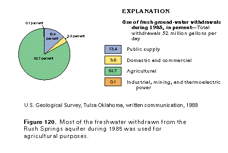
The Rush Springs aquifer is the principal aquifer in the area and is an important source for irrigation and public supplies. The aquifer is used extensively for irrigation, and water levels have been lowered as much as 50 feet in some areas because of irrigation pumpage. Withdrawals of water from the Rush Springs aquifer totaled about 52 million gallons per day during 1985 (fig. 120). Almost 43 million gallons per day was withdrawn for agricultural purposes. About 6 million gallons per day was withdrawn for public supply and about 2 million gallons per day was pumped for domestic and commercial uses. Less than 1 million gallons per day was withdrawn for industrial, mining, and thermoelectric-power uses.
Blaine Aquifer
The Blaine aquifer underlies an area of about 3,500 square miles in southwestern Oklahoma and northern Texas (fig. 117). The area is in the upper part of the Red River Basin in the Central Lowland Physiographic Province. It includes parts of Childress, Collingsworth, Cottle, Foard, Hardeman, King, Knox, and Wheeler Counties in Texas and parts of Beckham, Greer, Harmon, and Jackson Counties in Oklahoma. Average annual precipitation is about 20 to 24 inches. The Blaine aquifer is a major source of water for crop irrigation.
HYDROGEOLOGY
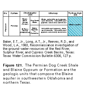
The Blaine aquifer, also cited in the literature as the "Blaine Gypsum aquifer" and the "Dog Creek-Blaine aquifer," consists of the Dog Creek Shale and the Blaine Gypsum or Formation, which are part of the Permian Pease River Group in Texas and the El Reno Group in Oklahoma (fig. 121). The formations consist of anhydrite and gypsum, shale, and dolomite. The anhydrite and gypsum are commonly cavernous. The caverns, cavities, and sinkhole development are the result of partial dissolution of the water-soluble rocks by circulating ground water.
The Blaine aquifer has a maximum thickness of about 400 feet. Water in the aquifer is mainly in porous dolomite and in solution openings in gypsum beds, and is generally under unconfined conditions. In places, the Dog Creek Shale is poorly permeable and confines water in the underlying Blaine Gypsum or Formation. Other Permian shales confine the aquifer from below. Wells completed in the Blaine aquifer commonly yield from 100 to 500 gallons per minute, but yields are as much as 1,500 gallons per minute in Texas and 2,500 gallons per minute in Oklahoma.
Water from the Blaine aquifer is a calcium-magnesiumsulfate type and is generally not suitable for public supply or for many industrial uses because of its mineral content. Concentrations of dissolved solids are generally between 2,000 and 6,000 milligrams per liter, and the sulfate concentration ranges from about 1,000 to 2,000 milligrams per liter. The chloride content also can be large (a concentration of more than 1,000 milligrams per liter has been reported). Pumpage from the Blaine aquifer is almost exclusively for irrigation and livestock watering purposes.
GROUND-WATER DEVELOPMENT
The Blaine aquifer is locally very permeable; in other areas, well yields might be small and insufficient for irrigation. This wide range in permeability is characteristic of aquifers that contain solution openings. Problems associated with development of the Blaine aquifer, aside from the marginal quality of the water as described above, include the possibility of inducing deeper-lying, moderately saline water into the pumped zone.
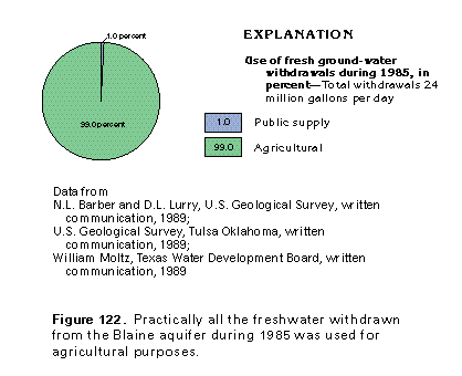
Withdrawals of water from the Blaine aquifer totaled about 24 million gallons per day during 1985 (fig. 122); about 17 million gallons per day were withdrawn in Oklahoma and about 7 million gallons per day in Texas. About 99 percent of the total was withdrawn for agricultural purposes, and the remaining 1 percent was withdrawn for public supply.
Central Oklahoma Aquifer
The Central Oklahoma aquifer underlies an area of about 2,900 square miles in central Oklahoma (fig. 117). The aquifer is in the Central Lowland Physiographic Province and underlies all or parts of Canadian, Cleveland, Kingfisher, Lincoln, Logan, Oklahoma, Payne, and Pottawatomie Counties. It is an important public supply for several suburban communities in the Oklahoma City area and is a source for numerous domestic water supplies.
HYDROGEOLOGY
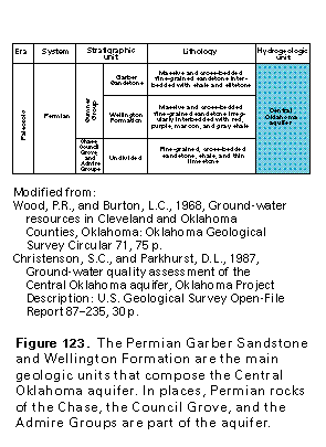
The Central Oklahoma aquifer, also known locally as the "Garber-Wellington aquifer," consists mainly of the Garber Sandstone and the Wellington Formation which are part of the Sumner Group of Permian age (fig. 123). Also included in the aquifer are the older Chase, the Council Grove, and the Admire Groups of Permian age. The aquifer consists of massive to cross-bedded, fine-grained sandstone that is interbedded with shale and siltstone.
The Central Oklahoma aquifer has a maximum thickness of about 1,000 feet and a saturated thickness that ranges from 150 to 650 feet. In places, the aquifer is overlain by the alluvial aquifers along the North Canadian and the Canadian Rivers, and water is available from both aquifers. Water in the Central Oklahoma aquifer is generally unconfined in about the upper 200 feet of the aquifer and partly confined or confined at greater depths.
Generally, the Central Oklahoma aquifer yields a calciummagnesium carbonate-bicarbonate type water that contains less than 500 milligrams per liter of dissolved solids. Water in the aquifer becomes more mineralized with depth. The depth to the base of freshwater in most of the area is between 500 and 1,000 feet. Wells completed in the aquifer commonly yield 100 to 300 gallons per minute and locally yield more than 500 gallons per minute.
GROUND-WATER DEVELOPMENT
The Central Oklahoma aquifer is an important source for domestic and public supplies. With the exception of Oklahoma City, all the major communities in central Oklahoma rely either solely on ground water or on a combination of ground- and sur-face-water supplies. The quantity of ground water withdrawn from the Central Oklahoma aquifer approximately doubled between 1970 and 1985.
The potentiometric surface of the aquifer has been lowered from 100 to 200 feet in areas of locally intense pumpage. In such areas, underlying saline water might move upward and result in deterioration of the chemical quality of the freshwater in the aquifer. Other problems include the possibility of contamination of the ground water by potentially toxic substances, including trace elements, organic compounds, and radioactive constituents. In some areas, contamination by oil-field brines and drilling fluids is a potential problem.
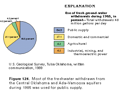
The amount of water withdrawn from the Central Oklahoma aquifer during 1985 was reported to be 40,000 acre-feet (about 36 million gallons per day); the largest use of the water was for public supply. Withdrawals for the various water-use categories during 1985 were reported for the combined Central Oklahoma and Ada-Vamoosa aquifers. The total water withdrawn from the two aquifers during 1985 was 48 million gallons per day. About 31 million gallons per day was withdrawn for public supply and about 13 million gallons per day was withdrawn for domestic and commercial uses (fig. 124). About 2 million gallons per day was pumped for agricultural purposes, and the same amount was withdrawn for industrial, mining, and thermoelectric-power uses.
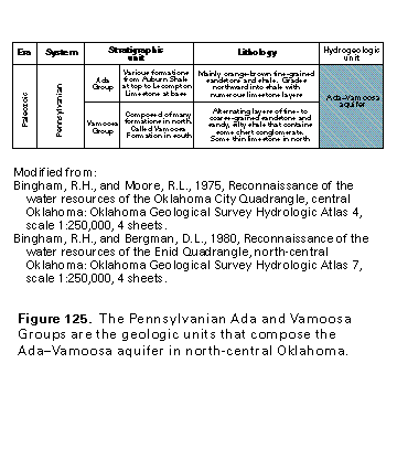
Ada-Vamoosa Aquifer
The Ada-Vamoosa aquifer underlies an area of about 2,300 square miles in east-central Oklahoma (fig. 117). The aquifer is in the Central Lowland Physiographic Province and underlies parts of Creek, Lincoln, Okfuskee, Osage, Pawnee, Payne, Pontotoc, Pottawatomie, and Seminole Counties. The aquifer extends in a band about 10 to 20 miles wide from northern Pontotoc County northward into Kansas. Several towns in the area rely entirely or in part on ground water for municipal supply.
HYDROGEOLOGY
The Ada-Vamoosa aquifer, also cited in the literature as the "Vamoosa-Ada aquifer," consists mainly of layers of fine- to coarse-grained sandstone irregularly interbedded with shale and limestone. The rocks are in the Ada and the Vamoosa Groups of Pennsylvanian age (fig. 125). The maximum thickness of the aquifer is about 900 feet. Aggregate thickness of the more permeable water-yielding sandstones in the aquifer is greatest south of the Cimarron River, where the maximum thickness is 550 feet. North of the river, the average aggregate thickness of sandstones is about 100 feet. The aquifer is unconfined in the east where it is near land surface; in downdip areas to the west, it is confined.
The regional dip of the Ada-Vamoosa aquifer is toward the west at about 30 to 90 feet per mile. The regional easterly slope of the water table is similar to that of the land surface. The approximate maximum thickness of the zone thatcontains water with a dissolved-solids concentration of less than 1,500 milligrams per liter decreases from 900 feet in the southern part of the area to 400 feet in the northern part. The total amount of water with dissolved solids of less than 1,500 milligrams per liter that is stored in the sandstone layers is estimated to be 60 million acre-feet. The amount of water that is theoretically available from storage is estimated to be 36 million acre-feet.
Generally, the water in the Ada-Vamoosa aquifer is a sodium-potassium chloride-sulfate type with a concentration of dissolved solids of less than 500 milligrams per liter. Yields of wells completed in the aquifer are commonly 25 to 150 gallons per minute, and are as much as 300 gallons per minute.
GROUND-WATER DEVELOPMENT
The Ada-Vamoosa aquifer is an important source of water for several towns in the area, as well as for some industries. Excessive pumpage may cause upward movement of saline water from the deeper, confined part of the aquifer. Brines and wastes from past oil-field operations might have caused some local contamination of the freshwater in the aquifer.
During 1980, withdrawals from the Ada-Vamoosa aquifer totaled 10 million gallons per day and were mostly for public and industrial supplies. During 1985, the withdrawals were reported for the combined Ada-Vamoosa and Central Oklahoma aquifers (see figure 124 and discussion in preceding section). Withdrawals from the Ada-Vamoosa aquifer were about 12 million gallons per day during 1985.
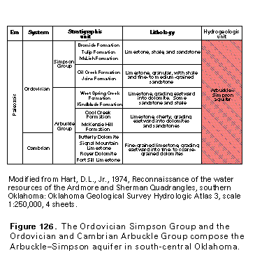
Arbuckle-Simpson Aquifer
The Arbuckle-Simpson aquifer is in an area of about 800 square miles in the Arbuckle Mountains and the Arbuckle Plains of south-central Oklahoma (fig. 117). The area is in the Central Lowland Physiographic Province and includes parts of Carter, Coal, Johnston, Murray, and Pontotoc Counties. Average annual precipitation is about 34 to 39 inches. The aquifer supplies small, but important, quantities of water, mainly for public supply.
HYDROGEOLOGY
The Arbuckle-Simpson aquifer consists of limestone, dolomite, and sandstone within the Simpson and the Arbuckle Groups of Ordovician and Cambrian age (fig. 126). The aquifer is as much as 9,000 feet thick. Its high permeability is the result of the enlargement of fractures, joints, and solution channels by partial dissolution of the rocks. The average transmissivity of the aquifer is estimated to be 15,000 feet squared per day and the average storage coefficient where the aquifer is confined is estimated to be 8¥10-3; in unconfined areas, the aquifer has an estimated specific yield of 20 percent. Freshwater may extend to depths of greater than 3,000 feet. Wells completed in the Arbuckle-Simpson aquifer commonly yield from 100 to 500 gallons per minute and locally yield as much as 2,500 gallons per minute. Springs that issue from the aquifer discharge from 50 to 18,000 gallons per minute. The water is a calcium bicarbonate type and commonly is hard but has a dissolved-solids concentration of generally less than 500 milligrams per liter.
In much of the area, the erosional remnants of the Ar-buckle Mountains form a rugged surface with as much as 600 feet of relief. Recharge to the aquifer occurs from precipitation that falls on the higher elevations of the aquifer outcrop areas and is estimated to be 4.7 inches per year. Intense faulting of the rocks affects the ground-water flow system because faults might act as barriers to ground-water movement or as conduits through which water travels to the surface. Water is discharged naturally from the aquifer by numerous springs and seeps; much of this discharge becomes the base flow of streams. The base flow of streams that drain the aquifer is estimated to be about 60 percent of the total annual runoff from the Arbuckle-Simpson outcrop area.
GROUND-WATER DEVELOPMENT
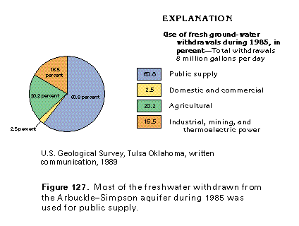
The largely undeveloped Arbuckle-Simpson aquifer is estimated to have 9 million acre-feet of freshwater in storage. The water is usually a calcium-magnesium bicarbonate type that is suitable for most uses. An estimated 8 million gallons per day of freshwater was withdrawn from the Arbuckle-Simpson aquifer during 1985 (fig. 127). About 5 million gallons per day was withdrawn for public supply, and about 2 million gallons per day was withdrawn for agricultural purposes. About 1 million gallons per day was pumped for industrial, mining, and thermoelectric-power uses, and about 200,000 gallons per day was withdrawn for domestic and commercial uses.
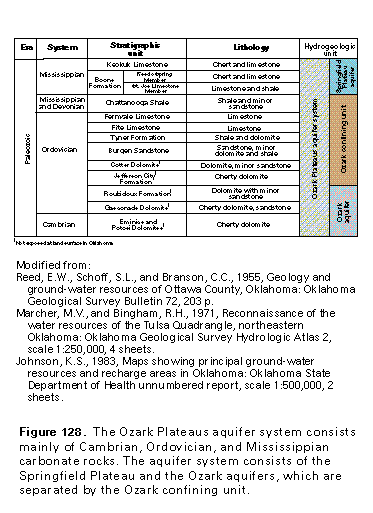
Ozark Plateaus Aquifer System
The Ozark Plateaus aquifer system underlies large areas of southern Missouri and northern Arkansas, and small areas of northeastern Oklahoma and southeastern Kansas. The aquifer system is discussed in detail in Chapters D and F of this Atlas. A brief description and discussion of the Oklahoma part of the aquifer system is presented here.
The Ozark Plateaus aquifer system consists mainly of Paleozoic carbonate rocks and underlies an area of about 2,400 square miles in northeastern Oklahoma (fig. 117). The area lies mostly in the Ozark Plateaus Physiographic Province, and includes all or parts of Adair, Cherokee, Craig, Delaware, Mayes, and Ottawa Counties. The northwestern corner of the area lies in the Central Lowland Physiographic Province, where the topography is mostly flat. The remainder of the area is relatively hilly and has springs, sinkholes, and caverns that are characteristic of karst topography. Average annual precipitation is about 40 to 44 inches. The aquifer system provides modest amounts of water whose chemical quality is suitable for most uses, including public supply.
HYDROGEOLOGY
The Ozark Plateaus aquifer system consists mostly of carbonate rocks that are Cambrian through Mississippian in age (fig. 128). The sedimentary rocks are on the western flank of the Ozark Uplift, which is a dissected dome centered in Missouri. The regional dip of the rocks is westward and southwestward. The aquifer system consists of two aquifers and an intervening confining unit.
The uppermost aquifer is the Springfield Plateau aquifer, which is exposed at the surface in Oklahoma and consists of the Keokuk Limestone and the Reeds Spring and the St. Joe Limestone members of the Boone Formation. The rocks are mainly chert and limestone with solution-enlarged openings and local cavernous zones. The Springfield Plateau aquifer has a maximum thickness of about 500 feet in Oklahoma and contains water under unconfined to confined conditions. Yields of wells completed in the aquifer range from a few gallons per minute to more than 80 gallons per minute, whereas springs that issue from the aquifer might discharge as much as 3,500 gallons per minute. Water in the aquifer is a calcium-magnesium bicarbonate type, is typically hard, and generally has a dissolved-solids concentration of less than 500 milligrams per liter. The Springfield Plateau aquifer has been referred to locally as the "Keokuk-Reeds Spring (Boone) aquifer."
A confining unit that consists of rocks of Ordovician, Devonian, and Mississippian age and is called the Ozark confining unit separates the Springfield Plateau aquifer from the Ozark aquifer (fig. 128). The Ozark aquifer, which is known locally as the Roubidoux aquifer, consists of dolomites and sandstones within the Roubidoux, the Gasconade, the Eminence, and the Potosi Formations of Ordovician and Cambrian age. The Ozark aquifer is not exposed at the surface in Oklahoma. The thickness of the Ozark aquifer ranges from 200 to 500 feet. Much of the water in the aquifer is in fractured dolomite and sandy zones where it is under confined conditions. Wells completed in the Ozark aquifer commonly yield from 50 to 250 gallons per minute and locally yield as much as 1,000 gallons per minute. Recharge to the aquifer is derived from precipitation that falls on aquifer outcrop areas in Missouri, about 50 to 100 miles east of the Oklahoma State line. The calcium-magnesium bicarbonate water in the Ozark aquifer is suitable for most uses; concentrations of dissolved solids in the water commonly range from 150 to 1,500 milligrams per liter. The Ozark aquifer is the principal public water supply for Ottawa County and nearby areas.
GROUND-WATER DEVELOPMENT
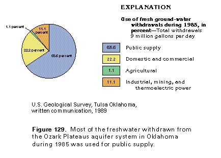
The chemical quality of water from the Ozark Plateaus aquifer system is suitable for most purposes, although the water may be moderately hard to very hard. Water in the Springfield Plateau aquifer, which is directly connected to the surface in places by sinkholes and caverns, is susceptible to contamination from surface sources. Withdrawals of water from the Ozark Plateaus aquifer system in Oklahoma totaled about 9 million gallons per day during 1985 (fig. 129). About 6 million gallons per day was withdrawn for public supply and about 2 million gallons per day was withdrawn for domestic and commercial uses. About 1 million gallons per day was pumped for industrial, mining, and thermoelectric-power uses, and about 100,000 gallons per day was withdrawn for agricultural purposes.