GROUND WATER ATLAS of the UNITED STATES
Arkansas, Louisiana, Mississippi
HA 730-F
Coastal lowlands aquifer system
There are two different files for each illustration
- A 72 ppi GIF file, suitable for screen viewing is accessed through
the thumbnail image
- An eps file, suitable for downloading to be printed or edited is accessed
through the "eps file" link. Most files are Adobe Illustrator
6.0, exceptions are noted. These files have been compressed with GNU's
gzip utility. If your web browser defaults to a screen display of the file,
turn on the "Load to local disk" option before downloading. Download
and process these eps files as ascii, not binary.
Relation between geology and permeability
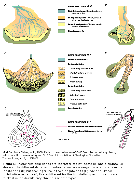
Figure 52 Diagrams of constructional deltas (97K)
 editable eps file F052.eps.gz
(291K compressed)
editable eps file F052.eps.gz
(291K compressed)
Figure 53 Diagramatic section showing a constructive
delta (97K)
 This illustration contains a placed image. Download the Adobe Illustrator
6 eps file F053.eps.gz (388K compressed)
which contains an imbedded Adobe Photoshop 3 (eps) file. You may also want
to download the editable Photoshop
file F053psh.eps.gz (291K compressed)
This illustration contains a placed image. Download the Adobe Illustrator
6 eps file F053.eps.gz (388K compressed)
which contains an imbedded Adobe Photoshop 3 (eps) file. You may also want
to download the editable Photoshop
file F053psh.eps.gz (291K compressed)
Figure 54 Map showing sand in percent (97K)
 editable eps file F054.eps.gz
(194K compressed)
editable eps file F054.eps.gz
(194K compressed)
Figure 55 Map showing estimated hydraulic conductivity
(97K)
 editable eps file F055.eps.gz
(194K compressed)
editable eps file F055.eps.gz
(194K compressed)
 editable eps file F052.eps.gz
(291K compressed)
editable eps file F052.eps.gz
(291K compressed) 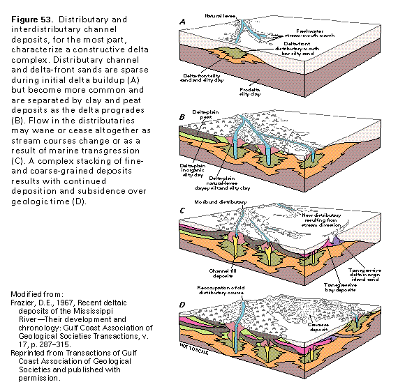 This illustration contains a placed image. Download the Adobe Illustrator
6 eps file F053.eps.gz (388K compressed)
which contains an imbedded Adobe Photoshop 3 (eps) file. You may also want
to download the editable Photoshop
file F053psh.eps.gz (291K compressed)
This illustration contains a placed image. Download the Adobe Illustrator
6 eps file F053.eps.gz (388K compressed)
which contains an imbedded Adobe Photoshop 3 (eps) file. You may also want
to download the editable Photoshop
file F053psh.eps.gz (291K compressed) 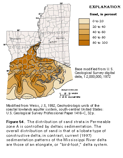 editable eps file F054.eps.gz
(194K compressed)
editable eps file F054.eps.gz
(194K compressed) 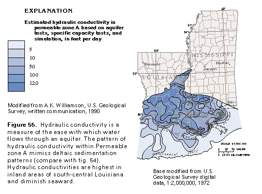 editable eps file F055.eps.gz
(194K compressed)
editable eps file F055.eps.gz
(194K compressed)