GROUND WATER ATLAS of the UNITED STATES
Arkansas, Louisiana, Mississippi
HA 730-F
Ozark Plateaus aquifer system
There are two different files for each illustration
- A 72 ppi GIF file, suitable for screen viewing is accessed through
the thumbnail image
- An eps file, suitable for downloading to be printed or edited is accessed
through the "eps file" link. Most files are Adobe Illustrator
6.0, exceptions are noted. These files have been compressed with GNU's
gzip utility. If your web browser defaults to a screen display of the file,
turn on the "Load to local disk" option before downloading. Download
and process these eps files as ascii, not binary.
Solution features
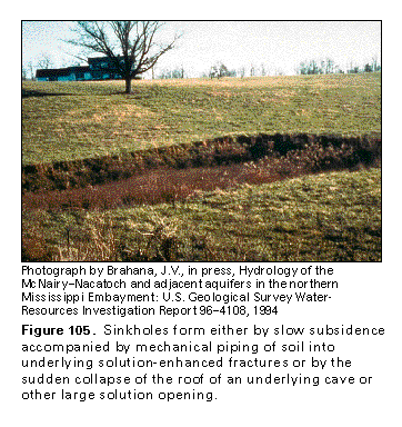
Figure 105 Photo of sinkhole (97K)
 This illustration contains a placed image. Download the Adobe Illustrator
6 eps file F105.eps.gz (3.1M compressed)
which contains an imbedded Adobe Photoshop 3 (eps) file. You may also want
to download the editable Photoshop
file F105psh.eps.gz (3.1M compressed)
This illustration contains a placed image. Download the Adobe Illustrator
6 eps file F105.eps.gz (3.1M compressed)
which contains an imbedded Adobe Photoshop 3 (eps) file. You may also want
to download the editable Photoshop
file F105psh.eps.gz (3.1M compressed)
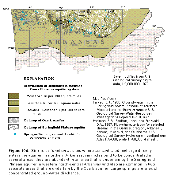
Figure 106 Map showing distribution of sinkholes in
rocks (97K)
 editable eps file F106.eps.gz
(194K compressed)
editable eps file F106.eps.gz
(194K compressed)
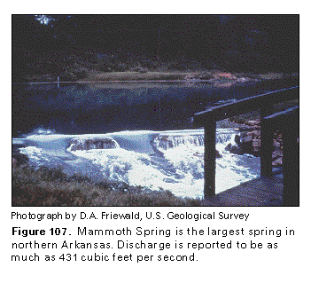
Figure 107 Photo of Mammoth Spring (97K)
 This illustration contains a placed image. Download the Adobe Illustrator
6 eps file F107.eps.gz (2.7M compressed)
which contains an imbedded Adobe Photoshop 3 (eps) file. You may also want
to download the editable Photoshop
file F107psh.eps.gz (2.7M compressed)
This illustration contains a placed image. Download the Adobe Illustrator
6 eps file F107.eps.gz (2.7M compressed)
which contains an imbedded Adobe Photoshop 3 (eps) file. You may also want
to download the editable Photoshop
file F107psh.eps.gz (2.7M compressed)
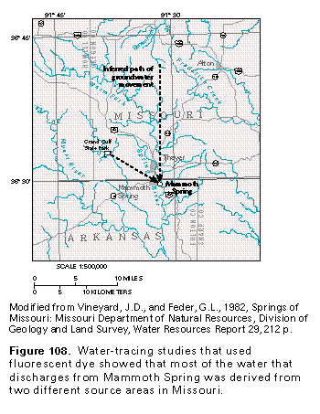
Figure 108 Map showing water-tracing studies in the
Mammoth Spring area (97K)
 editable eps file F108.eps.gz
(97K compressed)
editable eps file F108.eps.gz
(97K compressed)
 This illustration contains a placed image. Download the Adobe Illustrator
6 eps file F105.eps.gz (3.1M compressed)
which contains an imbedded Adobe Photoshop 3 (eps) file. You may also want
to download the editable Photoshop
file F105psh.eps.gz (3.1M compressed)
This illustration contains a placed image. Download the Adobe Illustrator
6 eps file F105.eps.gz (3.1M compressed)
which contains an imbedded Adobe Photoshop 3 (eps) file. You may also want
to download the editable Photoshop
file F105psh.eps.gz (3.1M compressed)