GROUND WATER ATLAS of the UNITED STATES
Arkansas, Louisiana, Mississippi
HA 730-F
Ozark Plateaus aquifer system
There are two different files for each illustration
- A 72 ppi GIF file, suitable for screen viewing is accessed through
the thumbnail image
- An eps file, suitable for downloading to be printed or edited is accessed
through the "eps file" link. Most files are Adobe Illustrator
6.0, exceptions are noted. These files have been compressed with GNU's
gzip utility. If your web browser defaults to a screen display of the file,
turn on the "Load to local disk" option before downloading. Download
and process these eps files as ascii, not binary.
Geologic factors that control permeability
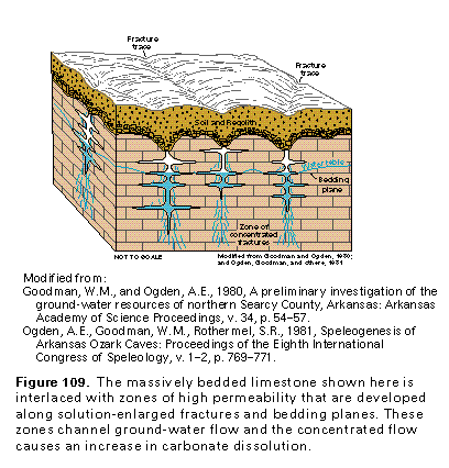
Figure 109 Diagramatic section (97K)
 This illustration contains a placed image. Download the Adobe Illustrator
6 eps file F109.eps.gz (194K compressed)
which contains an imbedded Adobe Photoshop 3 (eps) file. You may also want
to download the editable Photoshop
file F109psh.eps.gz (97K compressed)
This illustration contains a placed image. Download the Adobe Illustrator
6 eps file F109.eps.gz (194K compressed)
which contains an imbedded Adobe Photoshop 3 (eps) file. You may also want
to download the editable Photoshop
file F109psh.eps.gz (97K compressed)
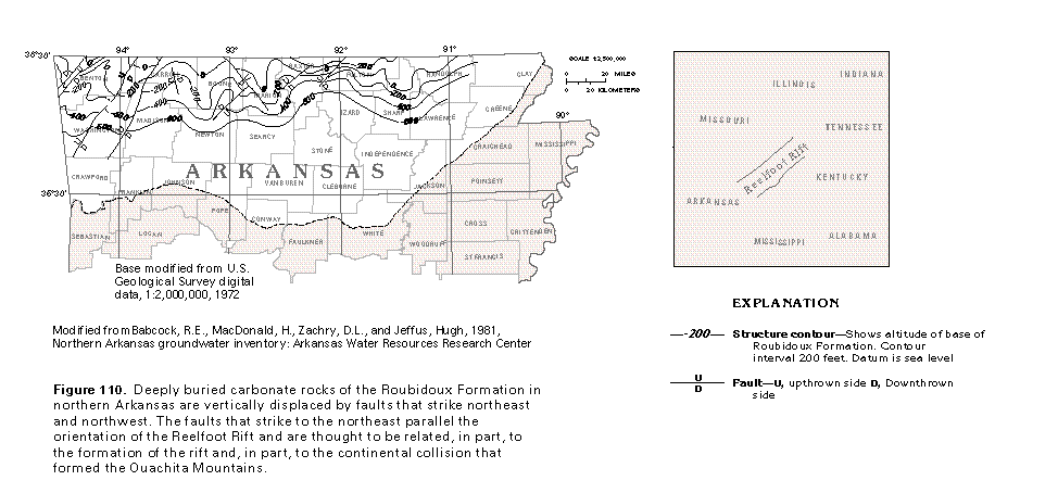
Figure 110 Map showing structure contours (97K)
 editable eps file F110.eps.gz
(97K compressed)
editable eps file F110.eps.gz
(97K compressed)
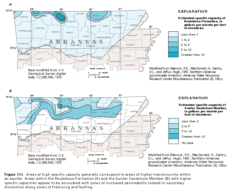
Figure 111 Maps showing estimated specific capacity
of the Roubidoux Formation and Gunter Sandstone Member (97K)
 editable eps file F111.eps.gz
(194K compressed)
editable eps file F111.eps.gz
(194K compressed)
Figure 112 Photo of vertical fractures in low-permeability
carbonate bedrock (97K)
 This illustration contains a placed image. Download the Adobe Illustrator
6 eps file F112.eps.gz (3.6M compressed)
which contains an imbedded Adobe Photoshop 3 (eps) file. You may also want
to download the editable Photoshop
file F112psh.eps.gz (3.6M compressed)
This illustration contains a placed image. Download the Adobe Illustrator
6 eps file F112.eps.gz (3.6M compressed)
which contains an imbedded Adobe Photoshop 3 (eps) file. You may also want
to download the editable Photoshop
file F112psh.eps.gz (3.6M compressed)
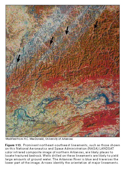
Figure 113 LANDSAT color infrared composite image of northern Arkansas
(194K)
 This illustration contains a placed image. Download the Adobe Illustrator
6 eps file F113.eps.gz (11M compressed)
which contains an imbedded Adobe Photoshop 3 (eps) file. You may also want
to download the editable Photoshop
file F113psh.eps.gz (11M compressed)
This illustration contains a placed image. Download the Adobe Illustrator
6 eps file F113.eps.gz (11M compressed)
which contains an imbedded Adobe Photoshop 3 (eps) file. You may also want
to download the editable Photoshop
file F113psh.eps.gz (11M compressed)
 This illustration contains a placed image. Download the Adobe Illustrator
6 eps file F109.eps.gz (194K compressed)
which contains an imbedded Adobe Photoshop 3 (eps) file. You may also want
to download the editable Photoshop
file F109psh.eps.gz (97K compressed)
This illustration contains a placed image. Download the Adobe Illustrator
6 eps file F109.eps.gz (194K compressed)
which contains an imbedded Adobe Photoshop 3 (eps) file. You may also want
to download the editable Photoshop
file F109psh.eps.gz (97K compressed)