
INTRODUCTION
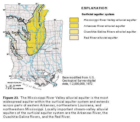
The surficial aquifer system of Segment 5 contains one major and three minor alluvial aquifers, of which the Mississippi River Valley alluvial aquifer is the largest and most important. Some regional studies have included the Mississippi River Valley alluvial aquifer as part of the Mississippi embayment aquifer system. Less extensive but locally important are the stream-valley alluvial aquifers of the Arkansas River, the Ouachita-Saline Rivers, and the Red River (fig. 23). Alluvial aquifers of the surficial aquifer system are characterized by their ability to yield large volumes of water and by their hydraulic interconnection with the rivers and streams that cross them. The alluvial aquifers generally are characterized by a basal gravel that fines upward to sand.
The alluvial aquifers of Segment 5, with the exception of the aquifer along the Arkansas River, are located within the Coastal Plain Physiographic Province; the Arkansas River alluvial aquifer is in the Ouachita Physiographic Province. The alluvial aquifers consist of gravel and sand deposits of Quaternary age and generally contain ground water under unconfined conditions. Beds and lenses of poorly permeable silt and clay, however, locally create confined conditions. The alluvial aquifers are capable of yielding large amounts of water, especially where the saturated thickness of the aquifer is large. Natural recharge to the alluvial aquifers is by precipitation that falls directly on the alluvial deposits, runoff from adjacent slopes, upward flow from aquifers underlying the alluvial aquifer, and infiltration from streams during periods of high flow when water levels in the streams are higher than those in the aquifers. Additional recharge from induced stream infiltration may take place where withdrawals from wells located near the streams lower the adjacent water table below the stream level. During dry periods, water may discharge from the alluvial deposits or adjoining aquifers into the streams, which contributes to base flow.
MISSISSIPPI RIVER VALLEY ALLUVIAL AQUIFER
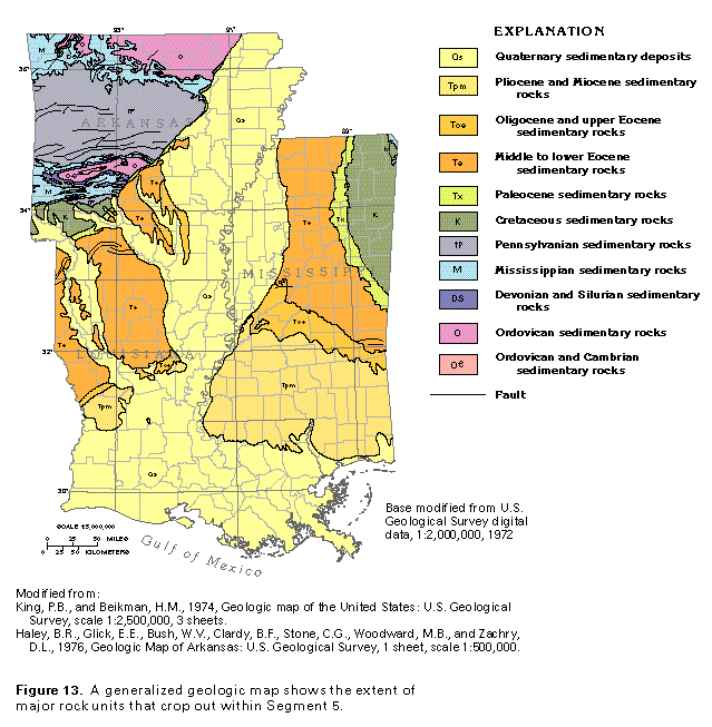
The Mississippi River Valley alluvial aquifer underlies the Mississippi River Valley, which is an extensive, low, flat plain that is a major physiographic feature of the segment. The aquifer extends southward from the head of the Mississippi Embayment, which is described in chapters D and K of this Atlas, and merges with the coastal lowlands aquifer system band of sediments in low-lying areas parallel to the Gulf Coast. The Mississippi River Valley alluvial aquifer underlies nearly 33,000 square miles in Segment 5 and ranges from about 75 miles wide between Vicksburg, Mississippi and Monroe, Louisiana to about 120 miles wide near the latitude of Little Rock, Arkansas. Sand, gravel, silt and minor clay deposits of Quaternary age that make up the aquifer in eastern Arkansas, northwestern Mississippi, and northeastern Louisiana also extend to the Gulf Coast in southeastern Louisiana (fig. 13). For purposes of this Atlas, however, the extent of the Mississippi River Valley alluvial aquifer is limited to the area shown in figure 23. Quaternary alluvial and deltaic deposits of the lower Mississippi River Valley generally are lithologically similar to and in good hydraulic connection with the underlying deposits of the coastal lowlands aquifer system and, therefore, are included in that system.
HYDROGEOLOGY
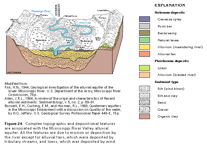
The Mississippi River Valley alluvial aquifer was deposited within a broad erosional stream valley formed by a preglacial drainage system. The erosional river valley served as a major drainageway for glacial meltwater, and considerable amounts of coarse-grained detritus (sand and gravel) were deposited in the valley by a braided, ancestral Mississippi River system. As the glaciers waned, sea level and base level rose, and the Mississippi River Valley aggraded. About 12,000 years ago, a braided, ancestral Mississippi River system gradually gave way to a meandering regimen as discharge and sediment load diminished. This is reflected in the geologic character of sediments contained within the Mississippi River Valley; the aquifer consists of a braided sequence of gravel and coarse sand that is overlain by a finer sequence (confining unit) of sand, silt, and clay that was mostly deposited by a meandering river system (fig. 24).
Downcutting, lateral migration, sudden channel shifting, shift in stream regimen, and aggradation by the Mississippi River have resulted in a wide variety of depositional and geomorphic landforms from Pleistocene to early Holocene time (fig. 24). During sea-level rise, the Mississippi River aggraded, and the valley infilled with alluvial deposits. Sea-level decline lowered the base level of the Mississippi River and caused the river to entrench into the adjoining valley fill. The Mississippi River Valley contains four stream terraces that formed in response to cyclic base-level change. Successive periods of entrenchment helped form the different erosional terraces. Braided streams that carried silt-laden glacial meltwater also served as the source of thick, wind-transported loess deposits.
The modern-day meandering Mississippi River system contains a wide assemblage of flood-plain depositional features that include point bars, natural levees, crevasse splays, backswamps, oxbow lakes, and alluvial fans. Meandering streams, which are formed by the helical, secondary flow of surface water as it moves downstream, shift their position by eroding outer banks of meander bends; transporting eroded, sandy sediment; and depositing it on the inside of downstream meander bends. When viewed in a vertical section, point-bar sediments are coarse at their base but fine upward. Natural levees build upward and outward, form as floodwaters rise above the bank level, and deposit sediment in bands that parallel the stream channel. Crevasse splays form where levees are breached and surface waters flow out onto the flood plain, which deposits sediment as a deltaic lobe. Backswamp areas generally form in low-lying, closed depressions, are underlain by silt and organic clay, and are covered by water for lengthy periods. Oxbow lakes form by meander cutoff, in which the upstream and downstream parts of a meander bend intersect, which shortens the length of the river. This crescent-shaped bend forms a closed lake that eventually fills with clay sediment. Alluvial fans form where smaller streams enter the valley and deposit sediment onto the flood plain. As surface waters diminish in depth and velocity, coarse detritus is deposited as a fan.
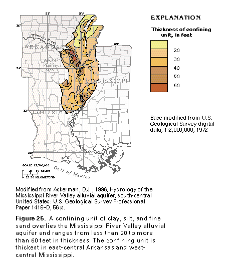
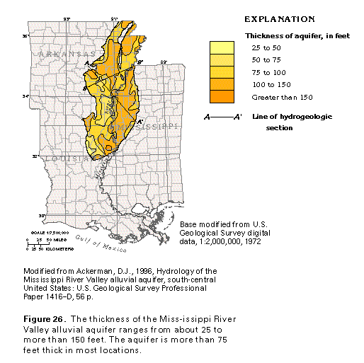
The deposits of the Mississippi River alluvial valley can be separated into two hydrogeologic units-an upper confining unit of silt, clay, and fine sand that impedes the downward movement of water into a lower coarse sand and gravel aquifer. The confining unit was deposited in flood plain, backswamp, meander belt, and some braided stream environments. The thickness of the confining unit averages between 20 and 30 feet throughout most of its extent but is missing in some places. The confining unit increases to more than 60 feet in thickness north of the Arkansas River in east-central Arkansas (Grand Prairie area) and along the Mississippi River Valley in part of west-central Mississippi (fig. 25) and exceeds 100 feet locally. The thickness of the underlying Mississippi River Valley alluvial aquifer ranges from about 25 to more than 150 feet (fig. 26). The Quaternary sand and gravel of the Mississippi River Valley alluvial aquifer continue southward but are considered to be part of the coastal lowlands aquifer system.
The layered sequence of aquifer and confining units that lies east and west of the alluvial plain and that is part of the Mississippi embayment aquifer system also extends beneath the Mississippi River Valley alluvial aquifer (fig. 27). In places, the Mississippi River Valley alluvial aquifer directly overlies and is hydraulically interconnected with aquifers of the Mississippi embayment aquifer system; in such places, water moves freely between the aquifers (fig. 27). The movement may be into or out of the Mississippi River Valley alluvial aquifer; this depends on whether the hydraulic head in the aquifer is higher or lower than that in the underlying aquifers. The ground water also moves from areas of high head toward areas of lower head. In other areas, the aquifer overlies poorly permeable strata that function as confining beds. In general, the permeability of the Mississippi River Valley alluvial aquifer is greater than that of the underlying aquifers.
RELATION BETWEEN GEOLOGY AND PERMEABILITY
Understanding the physical framework and facies of the Mississippi River Valley alluvial aquifer is useful in predicting permeability and hydraulic conductivity. Hydraulic conductivity is a measure of how rapidly water will pass through an aquifer and is a good indication of the probable yield of wells completed in the aquifer-the higher the hydraulic conductivity, the greater the expected well yield. Permeability is another way of measuring the ability of an aquifer to transmit water under a hydraulic gradient. Permeability is equal to the hydraulic conductivity of an aquifer multiplied by the gravitational constant and divided by the density and dynamic viscosity of the water. Transmissivity is a third way of measuring the capacity of an aquifer to transmit water of the prevailing viscosity. The transmissivity of an aquifer is equal to the horizontal hydraulic conductivity of the aquifer multiplied by the saturated thickness of the aquifer. The hydraulic conductivity, transmissivity, and permeability of an aquifer are directly influenced by the particle size, particle shape, degree of packing, sorting, amount of material that fills pore space, and cementation of the mineral and rock material that composes the aquifer. These factors are, in large part, a reflection of the depositional history of the rock. The distribution of the hydraulic conductivity of an alluvial aquifer, therefore, might be estimated from a map of the geologic facies of the aquifer because of the direct correlation between rock type and aquifer permeability. Hydraulic and lithofacies data also can be compared to help understand lateral variations within the alluvial sequence. Lithofacies maps of the Mississippi River Valley alluvial aquifer provide some insight to the distribution of hydraulic conductivity. To a degree, lithofacies maps can be used as a predictive tool in the search for overlooked or undeveloped sites that might prove suitable for ground-water resource development.
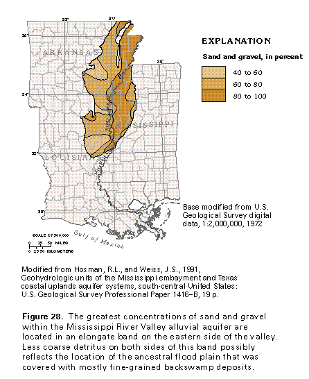
The distribution of the percentage of sand and gravel within the Mississippi River Valley alluvial aquifer is shown in Figure 28. The distribution of coarse-grained sediment indicates that higher concentrations of coarse detritus underlie the eastern one-half of the aquifer in a north-south band. In this area, sand and gravel compose more than 80 percent of the aquifer. Less coarse detritus is located on both sides of this band and may possibly be associated with an ancient flood plain.
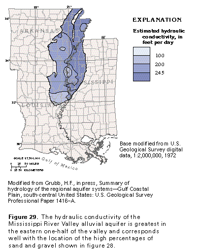
The map of the distribution of hydraulic conductivity of the Mississippi alluvial aquifer shown in figure 29 was constructed by using aquifer and specific-capacity test data, supplemented with trial-and-error estimates of hydraulic conductivity that were obtained by computer simulation of the ground-water flow system. The areas of highest hydraulic conductivity (greater than 245 feet per day) correspond well with the eastern part of the alluvial plain; this is an area in which sand and gravel have been concentrated (greater than 80 percent; fig. 28). In the western part of the alluvial plain (eastern Arkansas and northeastern Louisiana), the hydraulic conductivity of the alluvial aquifer generally ranges from 200 to 245 feet per day. Figure 28 shows a parallel reduction in the concentration of coarse-grained sediment in this area. Southward, the hydraulic conductivity of the aquifer diminishes; this reduction may reflect a progressive change in depositional facies southward from alluvial sand to a more clayey deltaic facies where the alluvial aquifer merges southward with the uppermost sediments of the coastal lowlands aquifer system.
RIVER-AQUIFER INTERACTION
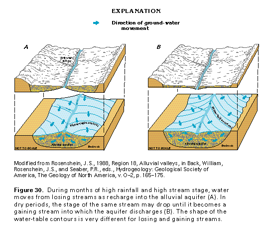
The hydrology of an alluvial aquifer is greatly influenced by the rivers that cross and incise it. When a stream channel incises an unconfined aquifer, the stream may recharge the aquifer, or the aquifer may discharge water to the river. River stage altitude tends to be high owing to greater stream flow; water from the river seeps laterally into the river banks and vertically through the streambed and thus raises water levels in the aquifer. When this occurs, the alluvial aquifer receives water from the river (fig. 30A), and the river is called a losing stream because it loses water to the aquifer. Water-table contours "point" downstream where they cross a losing stream. When streamflow and altitude of river stage are low, ground water stored in the aquifer and river banks is discharged to the river (fig. 30B). Under such conditions, water moves from the aquifer to the river, and the river is called a gaining stream. Where water-table contours cross a gaining stream, they "point" in an upstream direction.
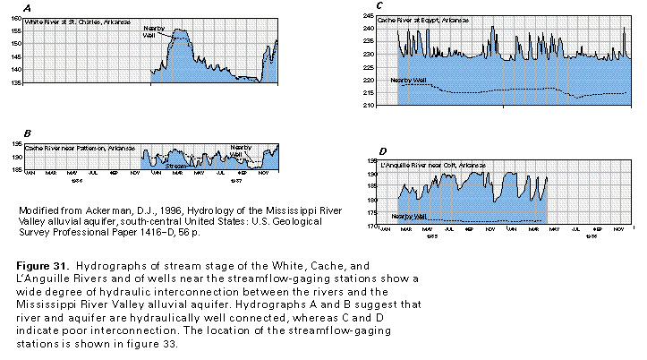
The Mississippi River Valley alluvial aquifer is incised by the Mississippi River, as well as several smaller rivers and streams that traverse the alluvial plain. The hydraulic connection of the rivers depends on the nature of the riverbed ma-terial or the depth to which the rivers penetrate the confining unit and aquifer. A deep incision by the major river drains tends to enhance the hydraulic connection of the rivers with the alluvial aquifer. Because the larger streams incise deeply, they are likely to breach the upper confining unit and, thus, are in direct hydraulic connection with the aquifer. These rivers, therefore, are more likely to be affected by withdrawals by large wells completed in the alluvial aquifer. In contrast, streams that do not or only partially breach the confining unit are not likely to be hydraulically well-connected with the aquifer and may even be above the regional water table. Hydrographs that compare river stage and water-table altitude in wells located near some of the rivers that are tributaries of the Mississippi River show different degrees of river-aquifer
interconnection (fig. 31). Stream hydrographs for the White River at St. Charles, Arkansas (fig. 31A) and the Cache River near Patterson, Arkansas (fig. 31B) closely correspond with water levels in nearby wells and show that high and low water levels in the aquifer parallel high and low flow periods in the rivers. The alluvial aquifer and the rivers are in direct hydraulic connection at these places, and water moves freely between the aquifer and the river. Conversely, hydrographs of stream stage and water levels in nearby wells for the Cache River at Egypt, Arkansas (fig. 31C) and L'Anguille River near Colt, Arkansas (fig. 31D) show poor correspondence. In these places, the rivers either have not breached or only partially breach the confining unit or alluvial aquifer and not as much water is exchanged between the river and the aquifer. In the Cache River area, long-term potentiometric decline has lowered water levels such that it lies beneath the streambed the entire year. Because the river stage levels are above aquifer water levels throughout the year, some water probably leaks downward from the rivers through the confining bed to re-
charge the aquifer.
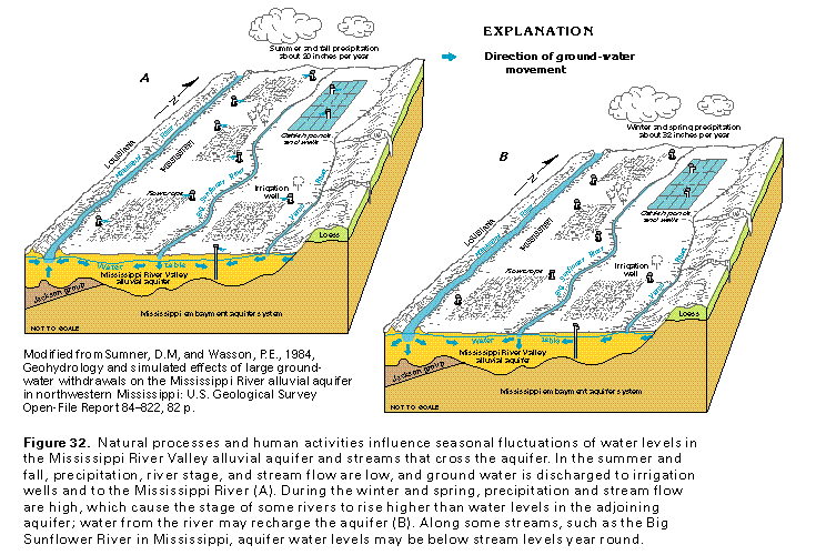
Large ground-water withdrawals have resulted in a long-term decline of water levels in some areas and also have reduced the amount of water that discharges to the rivers. By the early 1980's pumpage for irrigation and aquaculture, primarily to catfish farms, caused water levels in the alluvial aquifer to fall below the streambed of the Big Sunflower River in Mississippi (fig. 32). The Big Sunflower River and the lower part of the Yazoo River have historically acted as long-term drains from the alluvial aquifer; the potentiometric surface of the aquifer has sloped toward the Big Sunflower River even though the hydraulic connection was poor. During the early 1980's, pumpage for irrigation and catfish ponds caused water levels to decline from 1 to 2 feet per year and below the level of the lower stage of the Big Sunflower River. Because of the large amounts of water withdrawn, water levels in the aquifer did not recover during the winter and spring months even though the amount of precipitation is greater than the amount that falls during the growing season. Accordingly, water leaks downward from the Big Sunflower River to the aquifer year round. Water likewise moves from the Yazoo River to the aquifer throughout the year, but withdrawals from wells near the Yazoo River are not great enough to lower aquifer water levels below streambed levels. In contrast, flow between the Mississippi River and the aquifer is different at different times of the year. Precipitation is considerably less during the summer and fall, and the river stage is below that of the alluvial aquifer. In these conditions, water discharges from the aquifer to the river (fig. 32A). When precipitation increases during the winter and spring, the positions of river and aquifer water levels may be reversed (fig. 32B), and the Mississippi River becomes a source of recharge for the aquifer. Away from the rivers, aquifer levels are lowered locally owing to pumping of irrigation wells during the growing season but recover during the winter and spring. Water levels remain low near catfish ponds, however, because wells that supply the ponds are pumped year-round.
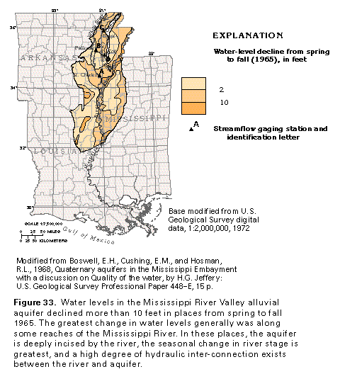
The configuration of the water table near rivers that incise the Mississippi River Valley alluvial aquifer also is influenced by seasonal change in river stage altitude. During the winter and spring, river-stage altitude tends to be high owing to greater stream flow; water from the river seeps into the river banks and raises water levels in the aquifer. During the summer and fall, streamflow and river-stage altitude are low, and ground water stored in the aquifer and river banks is discharged to the river. The seasonal changes in water levels in the alluvial aquifer can be large. For example, the decline in water levels in the Mississippi River Valley alluvial aquifer from spring to fall 1965 was greater than 10 feet in some places (fig. 33).
GROUND-WATER FLOW
Ground water within the Mississippi River Valley alluvial aquifer occurs largely under confined conditions. In areas where the aquifer is confined, recharge enters the alluvial aquifer by downward leakage through the confining unit. The confining unit is not continuous everywhere. Unconfined conditions occur in an area between the Black and the Cache Rivers in Mississippi County, Arkansas, and also along major river courses that have incised the confining unit.
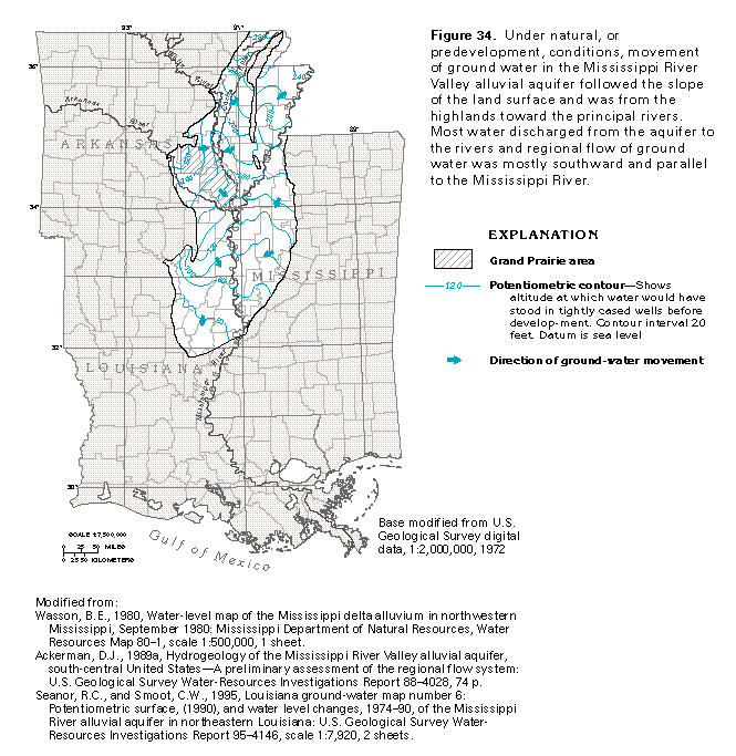
Before development of the Mississippi River Valley alluvial aquifer, water levels in the alluvial aquifer generally were less than 20 feet below land surface, and the regional direction of flow was southward (fig. 34). In the Grand Prairie area of Prairie, Monroe, and Arkansas Counties, Arkansas, flow generally was southeastward toward the White River and locally southward toward the Arkansas River. Downward leakage of rainfall (0.5-1.0 inch per year) through the upper confining unit accounted for nearly three-fourths of the recharge to the Mississippi River Valley alluvial aquifer before development. About one-fourth of the recharge to the alluvial aquifer before development was from upward leakage from Coastal Plain aquifers that underlie the Mississippi River Valley alluvial aquifer. Most of the discharge from the alluvial aquifer was to rivers that incised the aquifer.
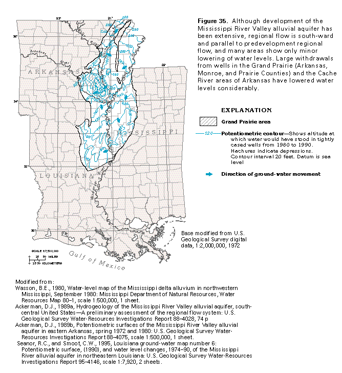
Well withdrawals, the construction of drainage canals and flood control structures, river navigational improvements, and changes in agricultural land use over the last 70 years have contributed to changes in the ground-water flow system and have reduced discharge from the Mississippi River Valley alluvial aquifer. Although development of this aquifer has been extensive, the regional movement of ground water generally remains unchanged (fig. 35). Many areas within the Mississippi River Valley have only a local change in the ground-water flow direction. The most dramatic area of change in water level-decline and ground-water flow direction is within the Grand Prairie and the Cache River areas of Arkansas. Large amounts of ground water are withdrawn in these areas to irrigate rice crops. The large withdrawals have caused water-level declines within the alluvial aquifer, which resulted in a cone of depression between the White and the Arkansas Rivers. A second depression in the potentiometric surface is located between the Cache River and the southern one-half of Crowleys Ridge (fig. 35).
WELL YIELD, PUMPAGE, AND LONG-TERM WATER-LEVEL DECLINE
Before the middle 1970's, most ground-water discharge was to the major rivers that incised the Mississippi River Valley alluvial aquifer. During the middle 1970's, withdrawals by wells reduced the amount of water that naturally discharged to the Mississippi River and its tributaries by nearly two-thirds. Well withdrawals presently (1997) represent the principal mechanism of ground-water discharge.
Properly constructed wells capable of yielding 500 gallons per minute can be completed almost anywhere within the Mississippi River Valley alluvial aquifer. Some irrigation wells yield from 1,000 to as much as 5,000 gallons per minute. However, long-term decline in water levels in some areas has resulted in diminished saturated aquifer thickness and reduced aquifer transmissivity. These factors limit the amount of water that can be withdrawn without producing an adverse impact on the aquifer.
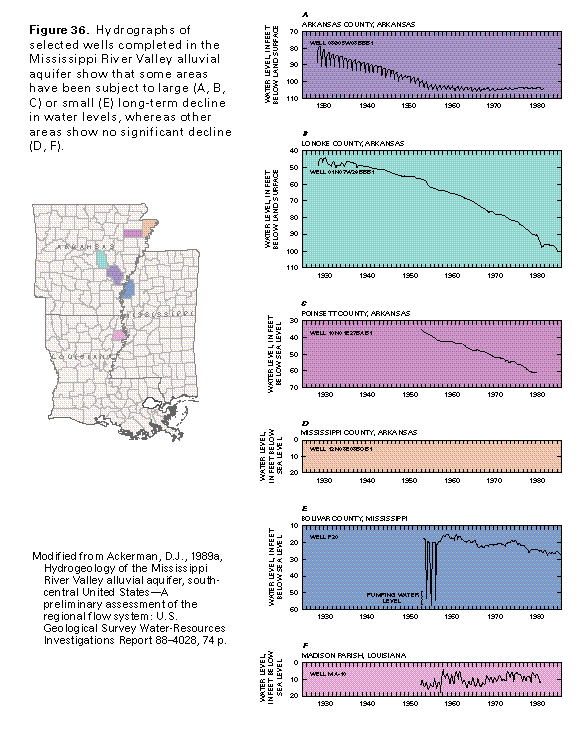
Hydrographs for some observation wells completed in the alluvial aquifer show a long-term decline of the potentiometric surface. Most of the long-term decline shown in figures 36A through C is attributed to rice-crop irrigation in eastern Arkansas. Water levels in some wells in Arkansas declined more than 55 feet between 1930 and 1985 as a result of irrigation withdrawals. Long-term declines also are evident locally in Mississippi, as shown in figure 36E, but are not as great as those in Arkansas. In some areas, the Mississippi River Valley alluvial aquifer water levels are not greatly affected by well withdrawals as indicated by figures 36D and F. These hydrographs show only seasonal fluctuations or response to variations in precipitation.
Concurrent with a long-term decline in the potentiometric surface of the alluvial aquifer has been a steady change in recharge to and discharge from the aquifer. Before development, recharge entered the aquifer in topographically high areas and most of the water was discharged to rivers. By the middle 1970's, the potentiometric surface had been greatly lowered, and downward leakage from rivers accounted for more than 20 percent of the recharge to the alluvial aquifer. Recharge by upward leakage from the deeper aquifers was increased by the decline in the potentiometric surface of the alluvial aquifer.
Of the water withdrawn by wells completed in the Mississippi River Valley alluvial aquifer, about 20 to 50 percent is obtained from ground water held in storage. A change in the volume of water that discharges from the aquifer or that recharges it results in a change in the volume of water in storage within the aquifer. In an unconfined aquifer, a change in storage is produced by draining or filling pore space within the aquifer. In a confined aquifer, a change in storage is produced by expansion or compression of the aquifer and the water it contains.
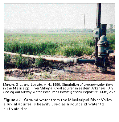
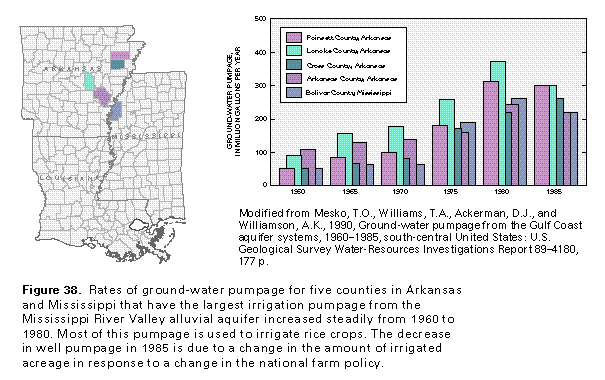
Increased rates of withdrawal from wells completed in the Mississippi River Valley alluvial aquifer has paralleled the increase in rice acreage. The cultivation of rice requires large quantities of water to maintain the 4- to 6-inch depth of water on rice fields (fig. 37) for the May to August growing season. The rice acreage expanded greatly between 1972 and 1982, but decreased in 1983 in response to a change in the national farm policy. Ground-water withdrawals in rice-growing counties of Arkansas and Mississippi (fig. 38) showed a steady increase from 1960 until 1980, then declined in 1985 in direct proportion to a decline in the amount of acreage irrigated for rice.
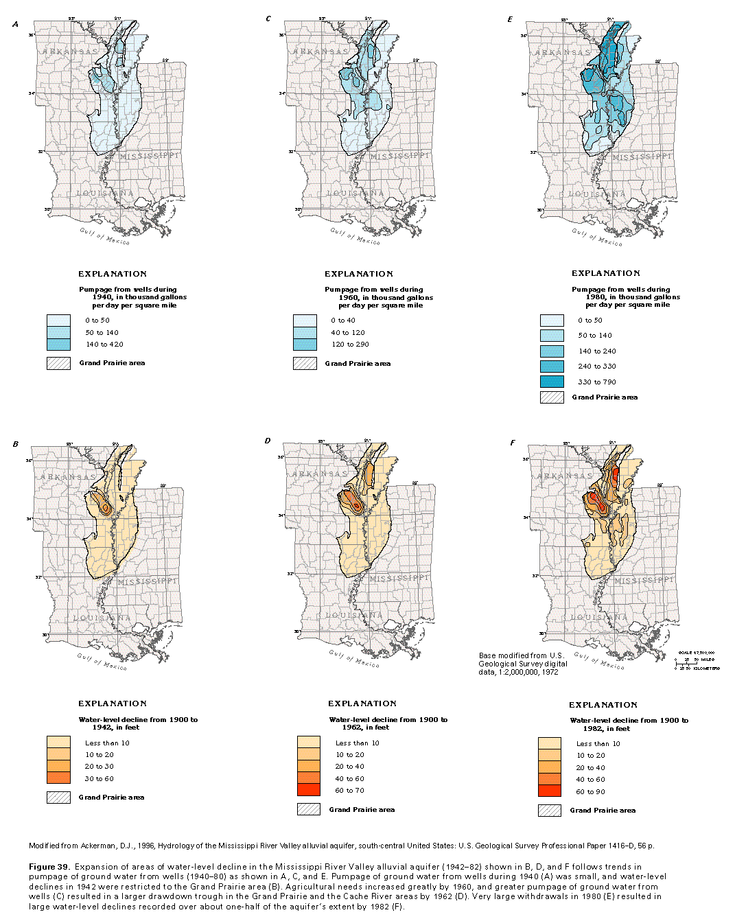
Pumpage from wells completed in the Mississippi River Valley alluvial aquifer in 1940, 1960, and 1980 (figs. 39A, C, E) illustrates a direct cause-and-effect relation with water-level declines in 1942, 1962, and 1982 (figs. 39B, D, F). In the Grand Prairie, Arkansas, area, adjacent to the White River, water-level decline within the Mississippi River Valley alluvial aquifer was reported as early as 1929. Areas with large water-level declines generally coincide with areas that have been stressed by heavy, long-term pumpage. In 1942, declines that ranged from 40 to 60 feet were reported in the Grand Prairie area (fig. 39B), where withdrawal rates during 1940 were high (fig. 39A). West of Crowleys Ridge, in the Cache River area, irrigation withdrawals were initiated in the 1940's with little decline in the potentiometric surface in 1942. However, as pumpage increased during 1960 (fig. 39C), water-level declines ranged from 40 to 60 feet (fig. 39D). The early 1980's marked a zenith in rice cultivation in Arkansas, northeastern Louisiana, and Mississippi. Large withdrawals from wells during 1980 (fig. 39E) contributed to water level-declines that ranged from 60 to 90 feet in the Grand Prairie and the Cache River areas of Arkansas and from 10 to 20 feet in northwestern Mississippi by 1982 (fig. 39F).
GROUND-WATER QUALITY
The quality of ground water can be characterized in terms of the hydrochemical facies of the water and its dissolved-solids concentration. Hydrochemical facies are determined by the dominant anions and cations contained within the ground water. For example, a calcium bicarbonate water is one which calcium ions are more than 50 percent of the total cations in the water, and bicarbonate ions are more than 50 percent of the anions. The dissolved-solids concentration is the total concentration of minerals that are in solution. In this report, the dissolved-solids concentration in ground water is used to classify the water as fresh, saline, or brine. The concentrations used to categorize the water are as follows:
| Term | Dissolved solids concentrations in milligrams per liter |
| Freshwater | Less than 1,000 |
| Slightly saline water | 1,000 to 3,000 |
| Moderately saline water | 3,000 to 10,000 |
| Very saline water | 10,000 to 35,000 |
| Brine | Greater than 35,000 |
The chemical constituents in ground water are determined, in part, by the mineralogy of the materials that compose the aquifer and by the length of time the water is in contact with these materials. Meteoric water contains few dissolved solids and enters the flow system as precipitation. As the meteoric water moves down the hydraulic gradient, either the water partially dissolves aquifer minerals or an exchange of ions takes place between the water and the minerals. Accordingly, water in the deeper parts of the aquifer tends to be more mineralized than that in the shallower parts. The water quality of the Mississippi River Valley alluvial aquifer also may be influenced by the upward movement of more mineralized water from underlying aquifers.
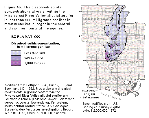
The quality of water within the Mississippi River Valley alluvial aquifer generally is suitable for most uses. For the most part, the water can be characterized as a calcium bicarbonate type with dissolved-solids concentrations that are usually less than 500 milligrams per liter (fig. 40). In some areas, however, dissolved-solids concentrations range from 1,000 to 3,000 milligrams per liter. Water-quality characteristics that often limit usefulness of water from the Mississippi River alluvial aquifer for public supply are excessive hardness and large concentrations of iron and manganese. The north-to-south increase in dissolved solids within the Mississippi River Valley alluvial aquifer is attributed to mineral-water interaction along ground-water flow paths.
FRESH GROUND-WATER WITHDRAWALS
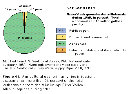
Total withdrawals from the Mississippi River Valley alluvial aquifer were about 5,050 million gallons per day during 1985 (fig. 41). About 96 percent of this amount was withdrawn for agricultural use; about 80 percent of the total ground water withdrawn was used for the irrigation of rice. Other agricultural uses include the irrigation of soybean, cotton, and corn, as well as withdrawals for aquaculture, primarily the raising of catfish, as well as crawfish and alligator farming. Crawfish farming is largely concentrated in southern Louisiana, whereas catfish farms are mostly located in Mississippi and the northwestern part of the Grand Prairie area in Arkansas. The aquaculture industry requires substantial pumpage to maintain water levels within artificial ponds. Withdrawals for all other uses during 1985 were only about 4 percent of the total withdrawals, or about 182 million gallons per day.
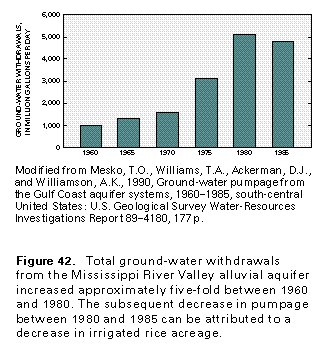
Total withdrawals from the aquifer increased steadily from 1960 to 1980 (fig. 42). The greatest increase in withdrawals was between 1970 and 1980 and corresponded to a large increase in rice acreage. A change in the national farm policy and the corresponding decrease in irrigated rice acreage partly account for the decrease in withdrawals between 1980 and 1985. Drier climatic conditions occurred in 1980 than 1985 and partly explain the decline in ground-water withdrawals.
STREAM-VALLEY ALLUVIAL AQUIFERS
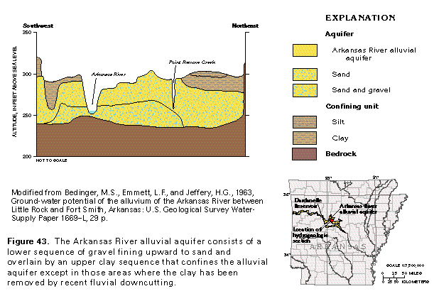
The Arkansas River, the Ouachita-Saline Rivers, and the Red River alluvial aquifers represent the minor alluvial aquifers of Segment 5 (fig. 23). All are stream-valley alluvial aquifers that consist of terraced alluvial deposits of Pleistocene age and flood plain alluvial deposits of Holocene age. Many of these aquifers are characterized by a lower unit of sand and gravel that was deposited by lateral fluvial accretion and an upper confining unit of silt and clay that was formed by vertically accreted flood deposits (fig. 43). Holocene sand, silt, and clay deposits that underlie the modern flood plain generally are restricted to a smaller area within the alluvial valley. For the most part, alluvial and terrace deposits that compose these stream-valley alluvial aquifers were deposited in response to sea-level changes during the Pleistocene. Highstands of sea level resulted in channel aggradation and lowstands were accompanied by incision of channels. Most of the minor alluvial aquifers in Segment 5 are thin, usually not exceeding 100 feet in thickness; some are less than 50 feet thick. The thickness of alluvium is most often controlled by pre-Pleistocene erosion and topography; the thickest deposits are within depressions or paleovalleys cut into the underlying bedrock.
Ground water within the stream-valley alluvial aquifers is partly under confined or artesian conditions; water-table conditions exist in the part of the aquifer that is adjacent to the river. Artesian conditions generally are in areas where upper terrace or flood plain deposits consist of silt and clay and act as a confining unit. Recharge to the stream-valley alluvial aquifers is by either infiltration of precipitation or recharge from underlying or adjacent water-yielding rocks; discharge is by seepage to streams that incise the aquifer or by evapotranspiration. In places where the flood plain is well-developed for agricultural purposes, the aquifer can be recharged by downward seepage of irrigation water. Water induced from the river into the aquifer where the water-table surface is lowered by nearby pumping from wells near the river also is a source of recharge. Recharge by upward discharge from underlying aquifers is much more prevalent in the Coastal Plain areas than the Arkansas River Valley or the Ouachita Mountains areas where the aquifer is underlain by poorly permeable bedrock. Ground-water flow in all three stream-valley alluvial aquifers is, for the most part, largely downstream with a local component of movement toward the major stream channels.
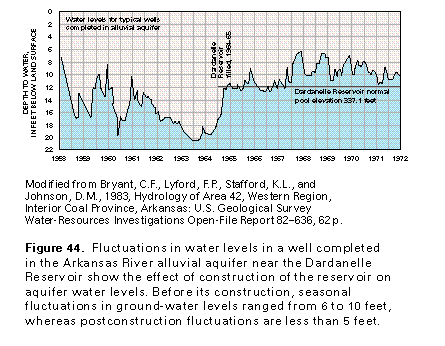
Water levels within the Arkansas, the Ouachita-Saline, and the Red River alluvial aquifers usually are within a few feet of land surface but are as much as 25 feet below the land surface in some places. Seasonal variation in the amount of rainfall and varying rates of ground-water withdrawal may cause as much as a 10-foot change in the potentiometric surface. Where the alluvial aquifer is hydraulically connected to the river, water levels vary in response to change in the river stage. Hydrologic conditions within the Arkansas and the Red River alluvial aquifers have been locally altered by the reservoirs, locks and dams, and levees built on these rivers. Such control structures have locally raised upstream river stages and nearby ground-water levels, which affect the local direction of ground-water flow. Changes in land use and in the amount of ground- and surface-water withdrawals for agricultural purposes also affect local ground-water flow patterns. The "dampening" effect on water-level fluctuations in the Arkansas River
alluvial aquifer as a result of construction of the Dardanelle Reservoir is shown on figure 44. Before reservoir construction, water levels near the river fluctuated seasonally as much as 10 feet each year. After the reservoir was completed, water levels have varied less than 5 feet per year.
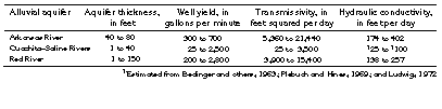
Several factors control the yield of water to wells completed in the Arkansas River, the Ouachita-Saline Rivers, and the Red River alluvial aquifers. These factors include the lithologic and hydraulic characteristics of the aquifer and the degree of hydraulic interconnection between the aquifer and the river. One of the most important factors that influences well yield is the saturated thickness of the aquifer. For example, assuming that the saturated thickness of the Ouachita-Saline Rivers alluvial aquifer was 25 feet and that a withdrawal rate of 1 gallon per minute resulted in 1 foot of drawdown, the yield to wells could not exceed 25 gallons per minute. Ranges of aquifer thickness, well yield, transmissivity, and hydraulic conductivity for stream-valley alluvial aquifers of Segment 5 are shown in table 1.
Wells are reported to yield from 300 to 700 gallons per minute from the Arkansas River alluvial aquifer, whereas the yield of wells completed in the Ouachita-Saline River alluvial aquifer is more variable and ranges from 25 to 2,500 gallons per minute. The yield of wells completed in the Red River alluvial aquifer generally ranges from 200 to 1,700 gallons per minute; some test wells are reported to yield as much as 2,800 gallons per minute.
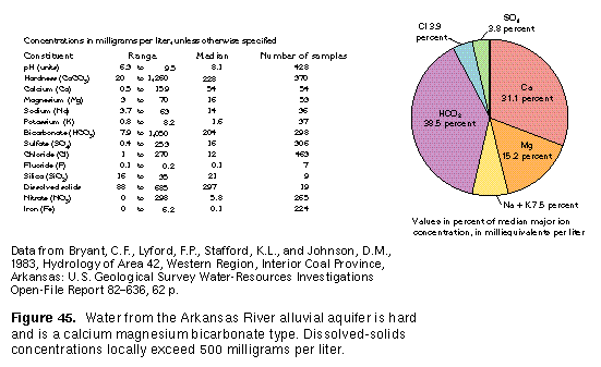
The quality and composition of ground water contained in stream-valley alluvial aquifers in Segment 5 varies considerably. Although the quality of water within the Arkansas River alluvial aquifer is suitable for most uses, large concentrations of iron and nitrate and excess hardness locally make the water undesirable for some public supply and industrial uses. Water within this aquifer is a calcium magnesium bicarbonate type (fig. 45). Ground-water contained within the Ouachita-Saline Rivers alluvial aquifer can vary greatly in chemical composition and hardness. Water from this aquifer ranges from a sodium bicarbonate to a sodium chloride type. Although water withdrawn from the Ouachita-Saline Rivers alluvial aquifer generally is suitable for irrigation, stock watering, domestic, and some industrial uses, concentrations of iron, manganese, nitrate, sulfate, chloride, and dissolved solids locally exceed the drinking water standards recommended by the U.S. Environmental Protection Agency. Water in the Red River alluvial aquifer is suitable chiefly for stock watering and irrigation purposes; concentrations of iron and dissolved solids in water from this aquifer may exceed U.S. Environmental Protection Agency recommended secondary drinking water standards.