INTRODUCTION
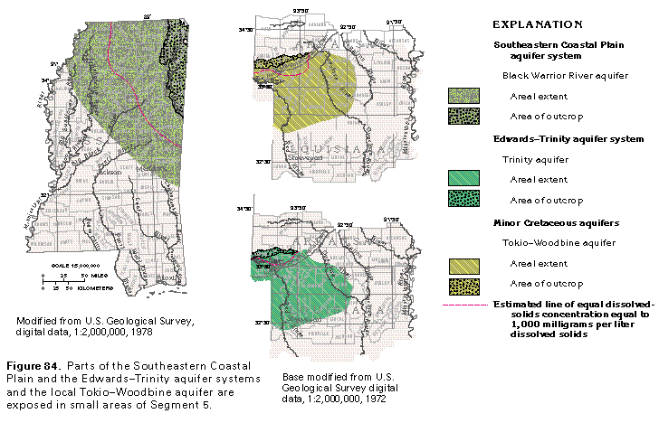
In Segment 5, Coastal Plain sediments of Cretaceous age compose parts of two aquifer systems and one minor aquifer. Small parts of the Southeastern Coastal Plain and the Edwards-Trinity aquifer systems are within the segment as is the Tokio-Woodbine aquifer, which is a minor aquifer in southwestern Arkansas (fig. 84).
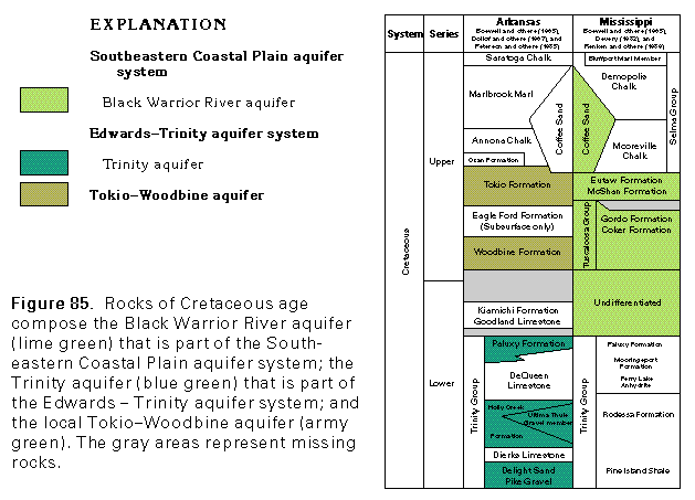
The Southeastern Coastal Plain aquifer system is a multi-aquifer system that consists of three major aquifers that comprise unconsolidated and poorly consolidated clastic sedimentary strata of Tertiary and Cretaceous age. Most of this aquifer system underlies Alabama, Georgia, and South Carolina and is described in Chapter G of this Atlas. However, the aquifer system extends westward into Mississippi where the Chick-asawhay and the Pearl River aquifers merge with and are considered to be part of the Coastal Lowlands and the Mississippi embayment aquifer systems, respectively. The Black Warrior River aquifer, which is the lowermost aquifer of the Southeastern Coastal Plain aquifer system, underlies about 32,000 square miles in Mississippi. The geologic formations that compose this aquifer are shown in figure 85.
The Edwards-Trinity aquifer system comprises rocks of Cretaceous age that crop out as a wide, looping band that extends across the middle of Texas, into the southeastern corner of Oklahoma and southwestern Arkansas. The aquifer system is separated into the Edwards, Edwards-Trinity, and the Trinity aquifers, all of which are described in detail in Chapter E of this Atlas. The Trinity aquifer is the only part of the Edwards-Trinity aquifer system that extends into southwestern Arkansas. The water-yielding formations that compose the Trinity aquifer in Arkansas are part of the Trinity Group (fig. 85).
The Tokio-Woodbine aquifer crops out and extends into the subsurface in a limited area in southwestern Arkansas but extends westward into Oklahoma and Texas where it is considered to be a minor aquifer and is known as the Woodbine aquifer (Chapter E of this Atlas). The Tokio-Woodbine aquifer in Arkansas is a minor aquifer that serves only as a local source of water for domestic use.
BLACK WARRIOR RIVER AQUIFER
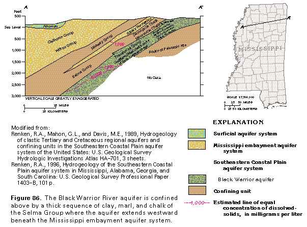
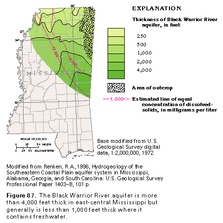
The Black Warrior River aquifer consists of an interbedded mix of fluvial sand and gravel, deltaic sand, silt and clay, and marginal marine sand, silt, and clay. In Mississippi, the Black Warrior River aquifer includes unnamed water-yielding rocks of Early Cretaceous age and the Tuscaloosa Group, the McShan and the Eutaw Formations, and the Coffee Sand of Late Cretaceous age. The Black Warrior River aquifer is confined by a thick sequence of clay and marl of the Selma Group, which effectively separates it from overlying rocks of the Mississippi embayment aquifer system (fig. 86). The Black Warrior River aquifer is greater than 4,000 feet thick in east-central Mississippi (fig. 87) but generally is less than 1,000 feet in thickness in much of the State.
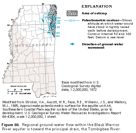
Ground-Water Flow
Water enters the Black Warrior River aquifer as precipitation that falls on the aquifer outcrop areas in northeastern Mississippi, as well as Alabama. Most of this water moves to streams as direct runoff, is returned to the atmosphere by evapotranspiration, or follows short flow paths in the aquifer and discharges to local streams as baseflow. A small part of the precipitation enters deeper parts of the ground-water flow system, moves downgradient into the confined part of the aquifer, and reemerges as discharge in the valleys of major streams (fig. 88). Ground water that discharges from the deeper, or regional, part of the flow system exits where erosion has deeply incised and exposed the aquifer along the Tombigbee River in western Mississippi and eastern Alabama.
Transmissivity
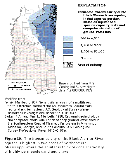
The highest estimated transmissivity (8,500-50,000 feet squared per day) within the Black Warrior River aquifer is in two areas in northeastern Mississippi (fig. 89). The largest area is where the aquifer is thickest and the part of the aquifer consists of highly permeable, fluvial strata. The aquifer is less transmissive (950-8,500 feet squared per day) as it extends northward, owing, in part, to a decrease in the amount of fluvial sand and gravel within the aquifer's lower section and, in part, to a thinning (less than 1,000 feet thick) of the aquifer. In the smaller area in the extreme northeastern-most corner of Mississippi, the aquifer consists primarily of unconsolidated, highly permeable gravel. Transmissivity decreases westward and southward because the aquifer contains saline water in its lower parts, and, thus, its effective thickness is less (fig. 89).
Ground-Water Quality
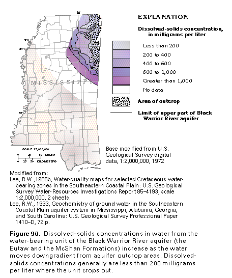
The principal chemical constituents that vary areally within the Black Warrior River aquifer are dissolved solids, dissolved iron, and dissolved chloride, all of which increase in concentration from outcrop to downgradient areas. Dissolved-solids concentrations generally are less than 400 milligrams per liter in water from the upper part of the aquifer where it crops out or is buried only to shallow depths (fig. 90). Dissolved-solids concentrations of more than 1,000 milligrams per liter may result from the mixing of fresh and saline (mostly mineralized water not flushed from the aquifer system) waters. The concentration of dissolved iron in the ground water of the Black Warrior River aquifer locally can range from 0.5 to 20 milligrams per liter.
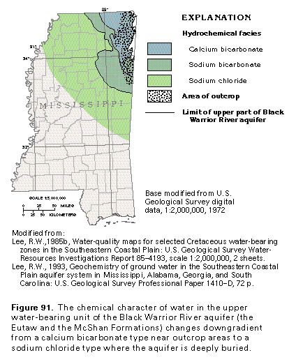
Changes in dissolved-solids concentrations correlate reasonably well with changes in the hydrochemical facies of the water in the aquifer (compare figs. 90 and 91). "Hydrochemi-cal facies" refers to a classification scheme used to describe the water in terms of the major anions and cations that the aquifer contains. Three major hydrochemical facies are in water from the upper part of the Black Warrior River aquifer. A calcium bicarbonate facies is mostly in updip, landwardmost interstream areas where the aquifer is recharged, whereas a sodium bicarbonate facies dominates the parts of the aquifer that are shallow downgradient areas of the flow system. The concentration of dissolved solids within the calcium bicarbonate waters is small, usually not more than 100 milligrams per liter. Sodium bicarbonate ground waters generally contain dissolved-solids concentrations that are not greater than 400 milligrams per liter. Dissolved-solids concentrations of greater than 1,000 milligrams per liter are characteristic of the sodium chloride hydrochemical facies.
TOKIO-WOODBINE AQUIFER
The Tokio-Woodbine aquifer serves as a local source of water for domestic use in southwestern Arkansas. The aquifer overlies and in places is hydraulically interconnected with water-yielding sands of the Trinity aquifer. The upper part of the Tokio-Woodbine aquifer consists of the Tokio Formation, which is a sequence of cross-bedded sand, gravel, and lignitic clay that grades downdip to sand and shale. The lower part of the aquifer comprises the Woodbine Formation, which is a red and gray clay that includes a massive, cross-bedded sand and gravel lithofacies where the formation extends into the shallow subsurface.
Freshwater in the Tokio-Woodbine aquifer is very limited in Arkansas and is restricted to a narrow band that extends southward from the outcrop area of the aquifer and lies between the Little and Little Missouri Rivers (fig. 84). Factors that appear to control freshwater within the aquifer include the degree of incision by rivers in outcrop areas and a rapid downdip decrease in permeability as the aquifer extends into the subsurface.
FRESH GROUND-WATER WITHDRAWALS
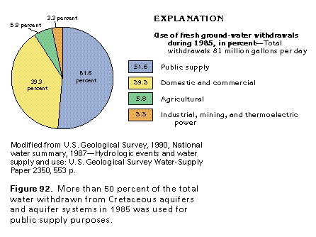
Total fresh ground-water withdrawals from the Black Warrior River, Trinity, and Tokio-Woodbine aquifers of Segment 5 were estimated to be 81 million gallons per day in 1985 (fig. 92). Public supply withdrawals represent about 42 million gallons per day, or nearly 52 percent of the total withdrawals. Domestic and commercial users withdrew nearly 32 million gallons per day, or about 39 percent of the total amount of water withdrawn. Pumpage by agricultural users was estimated to be about 4.7 million gallons per day, or about 6 percent of the total; industrial, mining, and thermoelectric users withdrew about 2.7 million gallons per day, or about 3 percent of the total.
TRINITY AQUIFER
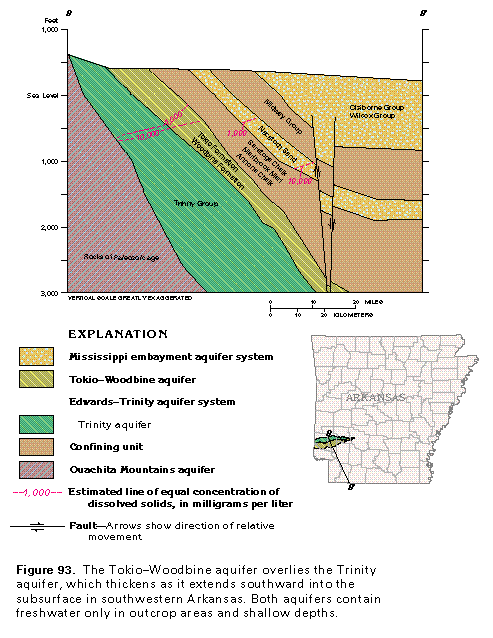
The Trinity aquifer consists of Coastal Plain rocks of Early Cretaceous age that yield mostly freshwater where they crop out in southwestern Arkansas. The Trinity aquifer is part of the larger Edwards-Trinity aquifer system, which extends westward into Oklahoma and southwestward across Texas (Chapter E of this Atlas) where it functions as an important source of potable water. The Trinity aquifer was deposited as part of a wedge of sediments that thickens southward from an erosional featheredge in southwestern Arkansas (fig. 93). The Trinity aquifer is overlain by the Tokio-Woodbine aquifer and underlain by the Ouachita Mountains aquifer. The Tokio-Woodbine aquifer is more than 1,000 feet thick (fig. 93) in the deep subsurface.
Several water-yielding geologic formations compose the Trinity aquifer in southwestern Arkansas; from oldest to youngest, they are the Pike Gravel, the Delight Sand, the Holly Creek Formation (including the Ultima Thule Gravel Member), and the Paluxy Formation (fig. 85). Intervening limestone, anhydrite, clay and shale of the Dierks and the DeQueen Limestones are poorly permeable and serve to separate water-yielding zones in the aquifer. The uppermost permeable rocks of the Trinity aquifer, which are equivalent to the Paluxy Sand, extend westward into Oklahoma where they are locally called the Antlers aquifer. The occurrence of freshwater within the Trinity aquifer is quite limited in Arkansas and is restricted to a 10- to 25-mile wide band that extends southward from aquifer outcrop areas between the Little and the Little Missouri Rivers (fig. 84).