WESTERN INTERIOR PLAINS CONFINING SYSTEM
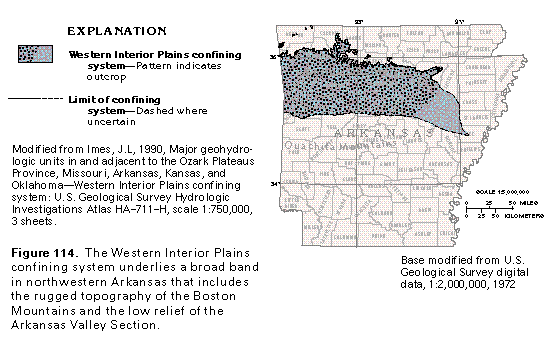
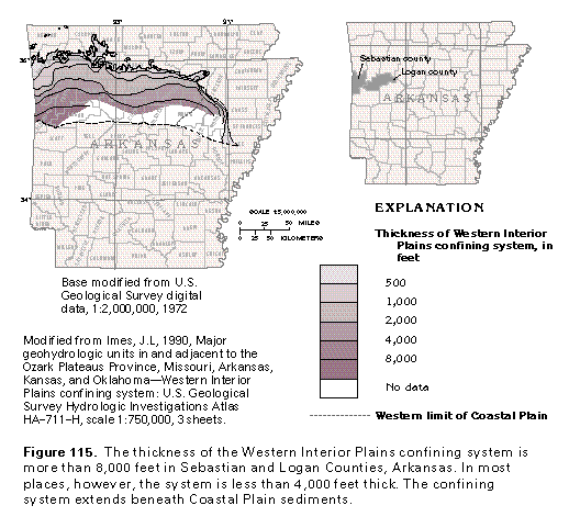
The Western Interior Plains confining system is part of a widespread, thick, geologically complex, poorly permeable, sedimentary sequence that extends eastward from the Rocky Mountains to western Missouri and northern Arkansas. In northern Arkansas, the Western Interior Plains confining system underlies a wide area that extends southward between 60 and 80 miles from its northern margin at the Boston Mountains escarpment to the Ouachita Mountains (fig. 114). The Western Interior Plains confining system consists of a sequence of shale, sandstone, and limestone of Mississippian to Pennsylvanian age that thickens to more than 8,000 feet as it extends southwestward (fig. 115). On a regional scale, the rocks that compose the confining system are poorly permeable and function as a confining unit. Locally, however, individual geologic units or parts of units within the confining system yield as much as 19 gallons per minute to wells. The confining system is, therefore, considered to be a minor aquifer.
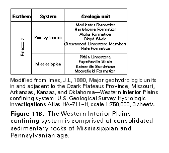
The Western Interior Plains confining system is topographically characterized by the rugged relief of the Boston Mountains and the low relief of the Arkansas River Valley. The Boston Mountains range in altitude from 1,000 to 2,000 feet above sea level, and the Arkansas River Valley ranges in altitude from 300 to 600 feet above sea level but locally contains east to west-trending ridges whose summits range from 1,000 to over 2,000 feet above sea level. Rocks of the confining system that underlie the Arkansas Valley Section are dominated by siltstone and shale that are overlain by a weathered zone that ranges from 10 to 30 feet thick. Sandstone beds of the system that are in the Arkansas Valley Section are well-cemented by silica and iron, resistant to erosion and form higher ridges. The Boston Mountains area, which is the highest erosional plateau in northern Arkansas, is underlain by sandstone, shale, and minor limestone beds of the confining system. The geologic formations that compose the confining system are shown in figure 116.
The ground-water flow system within the Western Interior Plains confining system can be separated into two zones: an upper zone within soil and highly weathered bedrock and a lower zone within moderately weathered to unweathered bedrock. The base of the weathered rock zone generally is no more than 300 feet below land surface. Weathering processes that act on the upper zone have increased its porosity and permeability, and the movement of water within it is primarily through interparticle pore spaces.
A map of the potentiometric surface of the upper zone of the Western Interior Plains confining system before development (fig. 117) shows the altitude of the water table within the weathered zone. Wells withdraw water from the confining system mostly for domestic use because well yield and water quality are inadequate for public supply. The predevelopment potentiometric map, therefore, probably is representative of current (1997) conditions. Water enters the confining system as precipitation that falls on topographically high interstream areas and then moves through the weathered zone toward stream valleys where much of the water is discharged. Regional ground-water movement toward the Arkansas River is southward.
Ground water within the unweathered zone is, for the most part, dependent on fracture density and fracture interconnection of the bedrock. Vertical or horizontal fractures or bedding planes can locally divide water-yielding strata into discrete, separate blocks that are hydraulically independent of each other. Joint sets, fractures, bedding-plane partings, and fault zones represent the fracture types most commonly associated with permeable zones of the unweathered part of the Western Interior Plains confining system. Bedding-plane partings, fracture cleavage in shaly rocks, and closely spaced joint sets in shale and siltstone beds of the confining system tend to be zones of high permeability that are more reliable sources of water than massive sandstone beds which contain less densely spaced fractures.
Secondary permeability within interbedded carbonate rocks of the Western Interior Plains confining system may locally be enhanced by meteoric dissolution. In the Boston Mountains area, outcropping carbonate rocks of the Pitkin Limestone, the Hale Formation, and the Brentwood Limestone Member of the Bloyd Formation locally contain cave systems sandwiched between poorly permeable shale beds, thus forming mazelike passageways.
Water levels within the Western Interior Plains confining system can fluctuate as much as 10 feet per year in response to seasonal variations in rainfall and evapotranspiration. These water-level fluctuations are directly attributed to the nature of the fractures in the rocks that compose the water-yielding zones. In narrow fractures, a small change in the volume of water can cause a significant change in the water level. In areas where fractures are widely spaced or poorly interconnected, small withdrawals could result in a large drawdown in a pumped well.
Wells completed in the weathered zone of the Western Interior Plains confining system generally yield only small volumes of water. In northwestern Arkansas, the yield of wells completed in the weathered zone ranges from 2.5 to 19 gallons per minute; much of the water was obtained from the Hale Formation and the Pitkin Limestone. The Atoka Formation also functions as a local water-yielding zone; the median yield of wells completed in the Atoka Formation is reported to be 9 gallons per minute.
The quality of ground water in the Western Interior Plains confining system is highly variable but meets most secondary drinking-water standards and is considered to be suitable for domestic and livestock uses. The quality of the water generally is not considered to be adequate for municipal supply. Principal constituents in the water are sodium and bicarbonate ions (fig. 118). Saline water is reported to be at depths that range from 500 to 2,000 feet below land surface.
OUACHITA MOUNTAINS AQUIFER
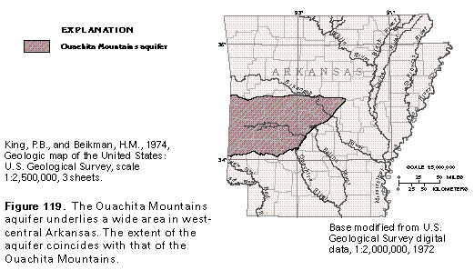
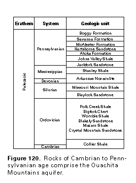
The Ouachita Mountains aquifer has a north-to-south width of 80 miles along the Arkansas-Oklahoma State line but progressively narrows eastward (fig. 119). The maximum length of the aquifer is about 130 miles. The Ouachita Mountains aquifer consists mostly of shale, sandstone, and chert beds of Cambrian to Pennsylvanian age (fig. 120), all of which were deposited in deep-marine water conditions; the coarsest deposits were part of turbidity-current or debris-flow deposits. The Ouachita Mountains are topographically characterized by alternating mountains and intermontane valleys to the north and a southernmost piedmont area. The mountains rise to summit altitudes of as much as 2,600 feet above sea level near the Oklahoma border but are only about 500 feet above sea level where they abut the Coastal Plain. Bedrock units that underlie the Ouachita Mountains have been thrust faulted, are highly folded, and contain overturned formations. The piedmont area is underlain by shale and sandstone and borders the Coastal Plain in southwestern Arkansas. The surface of the area generally is flat to gently rolling but contains a series of low ridges and swells that strike east to west.
The importance of the Ouachita Mountains aquifer is due more to its wide areal extent than to its water-yielding characteristics. Only limited quantities of water for domestic and nonirrigation farm uses can be obtained from wells completed in the aquifer. Base-flow discharge during periods of low or no precipitation is not large enough to sustain streamflow. Streams that drain areas of less than 100 square miles usually go dry every year, while streams that drain more than 100 but less than 200 square miles go dry every 10 years on average. Most wells completed in the aquifer yield less than 50 gallons per minute; "large-yield" wells generally are viewed as those capable of yielding more than 10 gallons per minute. Water levels in the aquifer can fluctuate by as much as 10 feet per year as rainfall and evapotranspiration rates change seasonally.
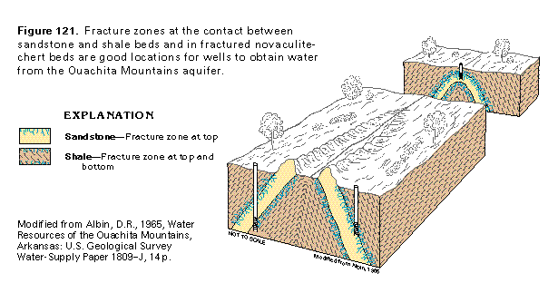
High-permeability fracture zones in the Ouachita Mountains commonly form along bedding-plane partings but are best developed where folding has caused differential movement along contacts between shale and sandstone beds. Wells in the Ouachita Mountain aquifers should be drilled along the flanks of anticlines or near a plunging anticlinal nose (fig. 121). Bedrock areas that include fractured chert-novaculite or limestone also are considered to be preferred drilling sites. Fault zones, which often contain milky quartz veins, also function as local conduits for ground-water flow within the Ouachita Mountains aquifer. However, the fault zones may conduct little water if they are filled with fault gouge or cemented breccia. In Hot Springs, Arkansas, faults are the principal conduit for deep-seated, thermal ground-water discharge. Most joints and fractures in the Ouachita Mountains aquifer, however, are within 300 feet of land surface. Joints and other fractures tend to close or decrease in width with depth owing to lithostatic pressure, which is the vertical pressure caused by the weight of overlying rock and soil.
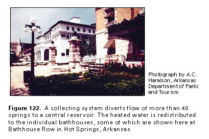
The thermal springs of the Hot Springs area represent an interesting and unique aspect of ground-water flow in the Ouachita Mountains aquifer. Before their development for commercial resort purposes in the late to middle 1800's, the Hot Springs area may have contained as many as 72 spring openings. Many of the springs were concentrated along a faulted and jointed bedrock area that is a few hundred feet wide and 0.25 mile long and that is located on the southwestern slope of Hot Springs Mountain. Many spring openings were walled in and covered to prevent contamination, and an extensive piping system was developed to supply hot water to various bathhouses (fig. 122).
Springs classified according to temperature are described as nonthermal and thermal types. Nonthermal, or cold, springs have about the same temperature as the mean annual air temperature in the area where they are located. Thermal springs are separated into hot- and warm-water types. Hot springs have temperatures that are higher than 98 degrees Fahrenheit. The temperatures of warm springs are less than 98 degrees Fahrenheit but higher than the mean annual air temperature. Many "cold-water" springs in the Hot Springs and the west-central Ouachita areas should more correctly be classified as warm-water springs. The temperatures of the hottest springs may have declined slightly with time. In 1804, the maximum temperature for the hottest spring was reported to be 154 degrees Fahrenheit, whereas the hottest spring temperature reported in 1972, for example, was 143.2 degrees Fahrenheit.
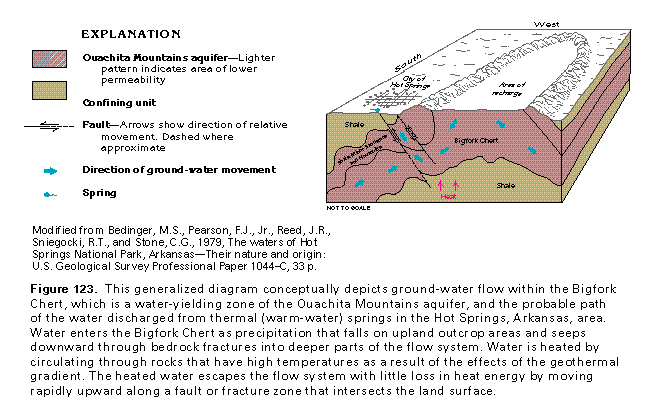
The mechanics of spring flow associated with thermal springs of central Arkansas parallels that of other fault- or fracture-related springflow systems. Topographic relief provides the hydraulic energy needed to drive the movement of water in fault- and fracture-spring settings, and the spring openings function as a focal point of concentrated ground-water discharge (fig. 123). Water enters the aquifer as precipitation in a topographically high area and is discharged in a topographically low area. A fault or fracture zone serves as a high-permeability avenue that allows ground water to exit the flow system. The principal difference between thermal and non-thermal springs is that thermal springs discharge water that has been circulated to a great depth. In the Hot Springs area, thermal springs discharge water that is estimated to have circulated to depths that range from 4,500 to 7,500 feet below land surface. However, thermal and nonthermal springs of the Hot Springs area discharge some water that apparently has circulated only to shallow depths. The heat that warms the water from warm- and hot-water springs is derived from the geothermal gradient, which is the progressive warming of the Earth's crust with depth. The normal increase in temperature with depth is about 1 degree Fahrenheit per 100 feet. In general, waters that circulate to great depths are warmer than those that circulate to shallower depths.
The Bigfork Chert, which is an important water-yielding zone in the Ouachita Mountains aquifer, is moderately to highly fractured and contains some intergranular permeability. Meteoric waters recharge the chert within a 3- to 10-square mile upland area northwest of the city of Hot Springs, in which the central part of a large anticline is exposed (fig. 123). The regional movement of ground water is to the southwest, and bedrock fracturing is of sufficient density and interconnection to allow some water to move downward to depths that range from 4,500 to possibly 7,500 feet below land surface. Ground water at such depths is warmed by heat conduction from adjoining low-permeability rocks. Fractured and faulted bedrock compose high-permeability zones that function as conduits for heated water and allow it to move rapidly to the surface with only a slight decrease in water temperature.