GROUND WATER ATLAS of the UNITED STATES
Alabama, Florida, Georgia, and South Carolina
HA 730-G
Southeastern Coastal Plain aquifer system
There are two different files for each illustration
- A 90 ppi JPEG file, suitable for screen viewing is accessed
through the thumbnail image.
- A tiff file is accessed through the "tiff file"
link. All files are Adobe Photoshop. These files have been compressed
with GNU's gzip utility. If your web browser defaults to a screen
display of the file, turn on the "Load to local disk"
option before downloading. Download and process these tiff files
as ascii, not binary.
Variations within the Aquifer System
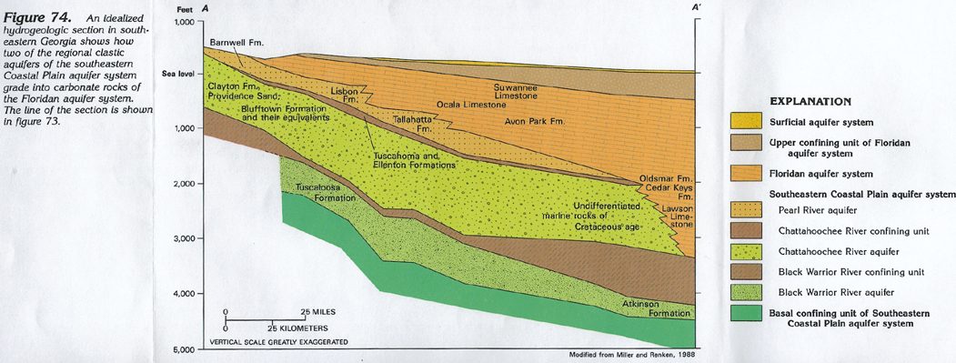
Figure 74 An idealized hydrogeologic section in southeastern
Georgia showing the gradation of the Southeastern Coastal Plain
aquifer system into the Floridan aquifer system (416K)
 downloadable tiff file G074.tif.gz (3.7MB
compressed)
downloadable tiff file G074.tif.gz (3.7MB
compressed)
Figure 75 An idealized hydrogeologic section trending
eastward across Alabama showing the composition of the Southeastern
Coastal Plain aquifer system (180K)
 downloadable tiff file G075.tif.gz (1.2MB
compressed)
downloadable tiff file G075.tif.gz (1.2MB
compressed)
 downloadable tiff file G074.tif.gz (3.7MB
compressed)
downloadable tiff file G074.tif.gz (3.7MB
compressed) 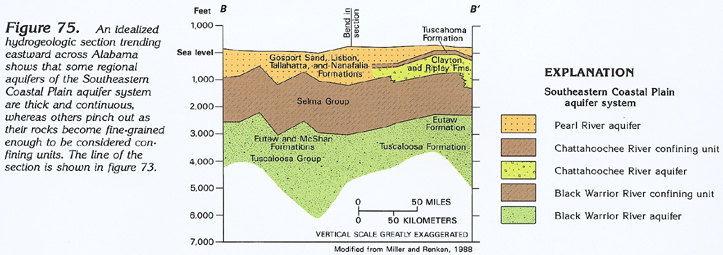 downloadable tiff file G075.tif.gz (1.2MB
compressed)
downloadable tiff file G075.tif.gz (1.2MB
compressed)