GROUND WATER ATLAS of the UNITED STATES
Alabama, Florida, Georgia, and South Carolina
HA 730-G
Regional summary
There are two different files for each illustration
- A 90 ppi JPEG file, suitable for screen viewing is accessed
through the thumbnail image.
- A tiff file is accessed through the "tiff file"
link. All files are Adobe Photoshop. These files have been compressed
with GNU's gzip utility. If your web browser defaults to a screen
display of the file, turn on the "Load to local disk"
option before downloading. Download and process these tiff files
as ascii, not binary.
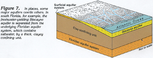
Vertical Sequence of Aquifers
Figure 7 Diagrammatic section showing the relationship
of the Floridan aquifer system to the Biscayne aquifer (136K)
 downloadable tiff file G007.tif.gz (971K
compressed)
downloadable tiff file G007.tif.gz (971K
compressed)
Figure 8 Map showing the location of the uppermost
Coastal Plain aquifers (208K)
 downloadable tiff file G008.tif.gz (2.8MB
compressed)
downloadable tiff file G008.tif.gz (2.8MB
compressed)
Figure 9 Map showing the location of the
intermediate aquifer system (208K)
 downloadable tiff file G009.tif.gz (2.8MB
compressed)
downloadable tiff file G009.tif.gz (2.8MB
compressed)
Figure 10 Map showing the location of the Floridan
aquifer system (208K)
 downloadable tiff file G010.tif.gz (2.8MB
compressed)
downloadable tiff file G010.tif.gz (2.8MB
compressed)
Figure 11 Map showing the location of the Southeastern
Coastal Plain aquifer system (208K)
 downloadable tiff file G011.tif.gz (2.8MB
compressed)
downloadable tiff file G011.tif.gz (2.8MB
compressed)
Figure 12 Map showing the location of the Piedmont
and Blue Ridge aquifers, the Valley and Ridge aquifers, and the
Appalachian Plateaus and Interior Low Plateaus aquifers (208K)
 downloadable tiff file G012.tif.gz (2.8MB
compressed)
downloadable tiff file G012.tif.gz (2.8MB
compressed)
 downloadable tiff file G007.tif.gz (971K
compressed)
downloadable tiff file G007.tif.gz (971K
compressed)