INTRODUCTION
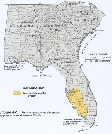
Collectively, aquifers in southwestern Florida that lie between the surficial aquifer system and the Floridan aquifer system are called the intermediate aquifer system in this Atlas. The approximate extent of the intermediate aquifer system is shown in figure 42. This aquifer system contains water under confined, or artesian, conditions, but does not yield as much water as the underlying Floridan aquifer system. Accordingly, the intermediate aquifer system is not extensively used, and its characteristics are not well known, especially where the Floridan is near the land surface and contains freshwater. The intermediate aquifer system is the main source of water supply in Sarasota, Charlotte, and Lee Counties, Fla., where the underlying Floridan aquifer system is deeply buried and contains brackish or saltwater.
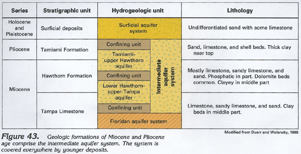
The intermediate aquifer system consists of sand beds and limestone lenses that are parts of the Tampa Limestone and Hawthorn Formation of Miocene age; and sand, limestone, and shell beds of the Tamiami Formation of Pliocene age (fig. 43). Clay confining units isolate the aquifers in the system from the Floridan and surficial aquifer systems. Where the rocks of the intermediate aquifer system grade into slightly yielding or nonyielding clayey beds, they become part of the upper confining unit of the Floridan aquifer system. Locally, in Clay, Brevard, and Indian River Counties, Fla., the Hawthorn Formation yields water, but its water-yielding beds are not continuous. In Glynn County, Ga., sand beds in the Hawthorn Formation are pumped locally for water supplies where the underlying Floridan aquifer system contains brackish water. These local aquifers in southeastern Georgia and northeastern Florida are not considered to be part of the intermediate aquifer system.
HYDROGEOLOGIC UNITS
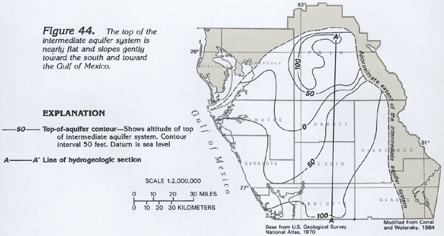
The top of the intermediate aquifer system slopes gently southward and southwestward. Its top is highest in western Polk County, Fla., and lowest in southern Charlotte County, Fla., (fig. 44). South of the area shown in figure 44, the top of the aquifer system becomes flatter, then rises slightly.
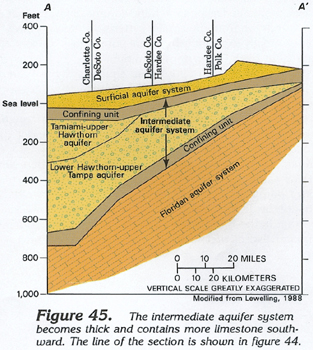
In many places, the intermediate aquifer system can be divided into two aquifers, the Tamiami-upper Hawthorn and the lower Hawthorn-upper Tampa aquifer, separated in most places by an unnamed confining unit. The aquifer system thickens southward from Polk County into Charlotte County, Fla., (fig. 45). Farther southward, in Collier County, the aquifer system thins as the lower Hawthorn-upper Tampa aquifer becomes predominately a clay with little permeability. The Tamiami-upper Hawthorn aquifer is the principal water-yielding part of the intermediate aquifer system in Glades, Hendry, Charlotte, Lee, and Collier Counties; elsewhere, the lower Hawthorn-upper Tampa aquifer is the major source of supply.
GROUND-WATER FLOW
The water-yielding beds of the intermediate aquifer system lie between clayey confining units. Therefore, the water in the aquifer system is under confined conditions except locally, where the upper confining unit is absent and the system is in direct hydraulic contact with the overlying surficial aquifer system. In most places, water moves downward from the surficial aquifer system and through the upper confining unit of the intermediate aquifer system; most of this water then follows short flowpaths and discharges to surface drainage. Some water, however, percolates downward through the lower confining unit of the system to recharge the underlying Floridan aquifer system. Locally, in western Charlotte and Lee Counties, some water leaks upward from the Floridan to the intermediate aquifer system.
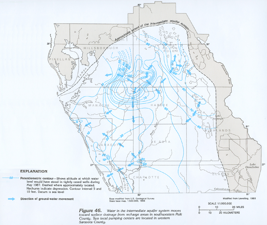
The lateral direction of water movement in part of the intermediate aquifer system is shown in figure 46. The flow arrows, which are drawn perpendicular to the potentiometric contours, show that water moves outward in all directions from two recharge areas in southwestern Polk County, where the potentiometric surface is more than 120 feet above sea level. From these points, lateral flow is toward major surface streams and the Gulf of Mexico. Two local pumping centers are shown by the depressions in the potentiometric surface in western Sarasota County.
Well yields of as much as 1,800 gallons per minute from the intermediate aquifer system have been reported. Most wells, however, yield 200 gallons per minute or less. Most transmissivity values reported for the intermediate aquifer system are 10,000 feet squared per day or less.
FRESH GROUND-WATER WITHDRAWALS
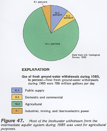
Withdrawals of freshwater from the intermediate aquifer system totaled about 298 million gallons per day during 1985. About 31 million gallons per day was withdrawn for public supply, and about 19 million gallons per day was withdrawn for domestic and commercial uses (fig. 47). About 233 million gallons per day was withdrawn for agricultural purposes, the principal water use. About 15 million gallons per day was withdrawn for industrial, mining, and thermoelectric-power uses.