INTRODUCTION
The crystalline-rock aquifers that underlie the Piedmont and Blue Ridge physiographic provinces in east-central Alabama, northwestern Georgia, and western South Carolina (fig. 85) are collectively called Piedmont and Blue Ridge aquifers in this Atlas. Similar aquifers extend northward throughout a large area from North Carolina into New Jersey, in a wide band near the center of Segment 11 of this Atlas. The Piedmont and Blue Ridge aquifers consist of bedrock overlain by unconsolidated material called regolith. Included in the regolith are: saprolite, which is a layer of earthy, decomposed rock developed by weathering of the bedrock; soil that develops on the upper part of the saprolite; and alluvium, which is mainly confined to stream valleys and may overlie soil, saprolite, and bedrock. The saprolite is by far the largest component of the regolith, and has a thickness of 150 feet in places. Saprolite thickness, however, is extremely variable.
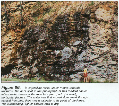
Because the crystalline rocks formed under intense heat and pressure, they have few primary pore spaces, and the porosity and permeability of the unweathered and unfractured bedrock are extremely low. This does not mean, however, that these rocks will yield no water. Ground water can be obtained from two sources: (1) the regolith, and (2) fractures in the rock (fig. 86). Locally, where the crystalline rocks consist of marble, the dissolving action of slightly acidic ground water has created solution openings that yield large volumes of water.
Although there are considerable differences in the mineralogy and texture of the rocks comprising the Piedmont and Blue Ridge aquifers, the overall hydraulic characteristics of the aquifers are similar. Locally, however, the occurrence and availability of ground water varies greatly because of the complex variability in rock type. Such variability makes it impractical to describe ground-water flow regionally. Accordingly, specific examples taken from local studies are used to illustrate different aspects of the hydrology of the crystalline rocks.
GEOLOGY
Bedrock underlying the Piedmont and Blue Ridge physiographic provinces consists of many different types of metamorphic and igneous rocks that are complexly related. Rock type varies markedly from place to place. For example, Blue Ridge and Piedmont rocks are divided into more than 90 units on the 1976 geologic map of Georgia. The main rock types are gneiss and schist of various compositions; however, extremely fine-grained rocks, such as phyllite and metamorphosed volcanic tuff, ash, and flows are common in places. Locally, quartzite and marble are present. Most of these metamorphic rocks were originally sediments, but some of them were originally igneous or volcanic materials. The degree of heat and pressure to which the original rocks were subjected, coupled with the degree of structural deformation (principally folding and shearing) that they have undergone, has determined the final texture and mineralogy of the rocks. Most of the rocks have undergone several periods of metamorphism. Locally, they contain mineralized zones, some of which are ore bearing.
All the metamorphic rocks have been intruded by large to small bodies of igneous rock that varies in composition from felsic (light-colored rocks that contain large quantities of silica) to mafic (dark-colored rocks that contain large quantities of ferromagnesian minerals). Large igneous intrusions consist of granite, quartz monzonite, and gabbro; these rocks are present in plutons that cover many tens of square miles. Smaller intrusions, such as dikes and sills, consist of both felsic and mafic rocks, including syenite, andesite, diabase, and pegmatite. The rocks are displaced by several major fault zones, some of which extend for hundreds of miles. Locally, shearing along large fracture zones has produced siliceous, intensely fractured rocks, such as mylonite or phyllonite.
RELATION OF ROCK TYPE AND WELL YIELD
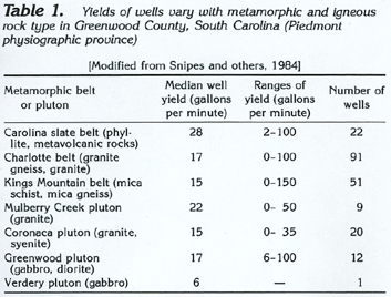
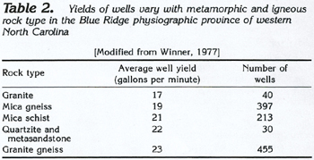
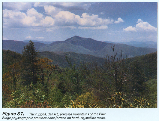
Although some wells completed in the Piedmont and Blue Ridge aquifers yield almost 500 gallons per minute, the average reported well yield is much less and generally is in the range of about 15 to 20 gallons per minute. Yields of large-diameter wells drilled for public water supply average about 30 gallons per minute. Part of the variation in yield depends upon the type of rock in which the well is completed. Well-yield data for Greenwood County, S.C., which is in the Piedmont physiographic province, are summarized in table 1. Well-yield data from a study conducted along the Blue Ridge Parkway in western North Carolina are summarized in table 2, and are considered to be representative of rocks of the Blue Ridge physiographic province shown in figure 86; typical topography of the province is shown in figure 87. Data in both tables indicate that granite gneiss can be expected to yield more water than mica schist and mica gneiss. Quartzite, where present, yields almost as much water as does granite gneiss. The yield of granite is directly dependent on the degree to which the granite has been fractured. Surprisingly, the fine-textured rocks of the Carolina slate belt (table 1) locally yield large volumes of water. This is because these rocks are intensely fractured in the areas where the well data were collected; similar rocks in North Carolina, where they are less fractured, have less than average yields.
Solution openings commonly have been developed by the dissolving action of slightly acidic ground water in marble that is locally present in the Piedmont and Blue Ridge physiographic provinces. These openings first develop as enlargements of joints and foliation planes, and some of them enlarge until they form large conduits. Wells penetrating such solution openings will yield large volumes of water.
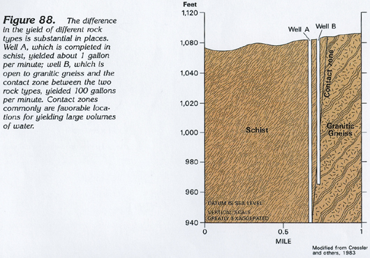
Contact zones between crystalline-rock types are favorable places for the location of wells yielding large volumes of water. Two wells in Carroll County, in western Georgia, are shown schematically in figure 88. Well A missed the contact zone between granitic gneiss and schist and was completed in the schist. This well yielded only about 1 gallon per minute. Well B penetrated the contact zone between the two rock types and bottomed in the granitic gneiss. This well yielded 100 gallons per minute. Although not all contact zones have such a great contrast in well yield, they are generally favorable places to locate wells.
RELATION OF FRACTURING AND WELL YIELD
Fractures in the crystalline rocks of the Piedmont and Blue Ridge physiographic provinces traditionally have been described as steeply inclined, intersecting openings that are generally more numerous at shallower depths. This is because the fractures tend to be sealed as lithostatic pressure increases with depth. Bedrock ranges from unfractured to intensely fractured in those places where two or more fracture sets intersect.
Wells that penetrate no fractures will yield little or no water. Wells that penetrate only a few small, shallow fractures initially may have an adequate yield; however, after the fractures are drained, well yield can suddenly decrease and the sustained yield may be small. Wells that penetrate only one large fracture have similar yield characteristics. Wells that penetrate several small fractures as well as one large one probably will have a large sustained yield. Wells that penetrate intensely fractured rock will be the most dependable in terms of sustained yield.
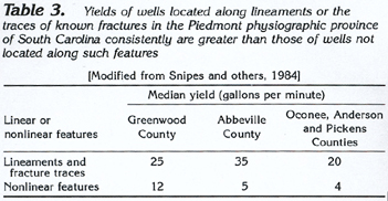
Steeply inclined fractures are commonly expressed at the land surface as lineaments (straight-line orientations of topographic or geologic features or both); these lineaments generally are about 1 mile or more long. Lineaments may be expressed as straight ridge lines or stream reaches, extensions of rock contacts or igneous dikes, the axes of folded rocks, shear zones, and so forth. Lineaments can be identified from satellite imagery, aerial photographs, and topographic maps. Wells drilled along such lineaments or along known fracture traces, consistently yield more water than randomly located wells (table 3).
Some wells yielding large volumes of water that were recently drilled in the Piedmont and Blue Ridge physiographic provinces of Georgia and South Carolina penetrated horizontal or nearly horizontal fractures that are 1 to 8 inches high at depths that range from about 30 to 1,650 feet. Artesian pressure in some of these horizontal fractures indicates that they are connected to recharge areas at higher altitudes by vertical or steeply inclined fractures. These nearly horizontal fractures are thought to be stress-relief fractures that are formed in the manner shown schematically in figure 89. Pre-existing stress (fig. 89A) in the rock column, shown by the arrows, is relieved as erosion removes some of the overlying rock (fig. 89B), allowing hairline fractures to form. Continued erosion (fig. 89C) results in a slightly arched, somewhat lens-shaped fracture that has the greatest vertical separation under a topographically low area, such as a stream valley where more overburden has been removed. These types of fractures are most common in coarse crystalline rocks, such as monzonite, granite gneiss, biotite gneiss, amphibolite, and interlayered gneiss and schist. The areal extent of these features is not known, but sparse well data indicate that the fractures extend from about 100 feet to more than 1,000 feet from the wells.
RELATION OF REGOLITH THICKNESS AND WELL YIELD
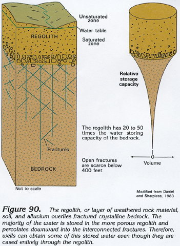
The regolith that forms a nearly continuous layer over the bedrock in the Piedmont and Blue Ridge physiographic provinces consists of saprolite., soil, and alluvium. The saprolite is ordinarily the thickest component of the regolith and its character varies greatly depending on bedrock type. Material in the regolith varies from clay and rock fragments (mostly in the saprolite) to sand and boulders in stream alluvium. Accordingly, the porosity of the regolith varies greatly, but it is everywhere more porous than the underlying, unweathered bedrock. At any given place, the porosity of the regolith usually decreases with depth as the degree of weathering of the saprolite decreases. Water within the bedrock primarily is present in fractures that decrease in number and tend to be sealed at depth. The relation of the regolith and the fractured bedrock is shown schematically in figure 90.
Because the porosity of the regolith is much greater than that of the bedrock, the regolith has the capacity to store a much larger volume of water. The cylinder-and-cone sketch at the right side of figure 90 illustrates this diagrammatically. Most of the stored ground water is in the cylinder, which represents the regolith. The smaller, tapering, cone-shaped area below represents water stored in fractures in the bedrock. The volume of the cone decreases with depth proportionately as the number of fractures decreases.
The regolith and bedrock fractures are directly connected to form an integrated ground-water flow system in which the regolith functions as a reservoir, providing water to the interconnecting fractures in the bedrock. Even though wells in crystalline-rock areas are ordinarily cased through the regolith, the fracture- regolith interconnection allows water stored in the regolith to move vertically into the fractured rock and then through the fractures to the well.
RELATION OF REGOLITH THICKNESS AND TOPOGRAPHY
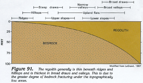
The thickness of the regolith can be estimated from the topographic setting of a particular location. Usually, only a thin cover of regolith underlies ridges, hill tops, steep draws, and steep slopes (fig. 91) because of the combination of less fracturing and more erosion on the topographically high and steep areas. Narrow valleys, most upland flats, and gentle slopes have moderate regolith thicknesses. The greatest thicknesses of regolith, in places as much as about 100 feet, are under broad draws, broad valleys, and a few upland flats. Wells yielding 50 gallons per minute or more in the Piedmont and Blue Ridge physiographic provinces are most common in broad draws and valleys where regolith thickness exceeds 50 feet. Wells located on slopes and hills will generally yield only small volumes of water (table 4).
GROUND-WATER FLOW
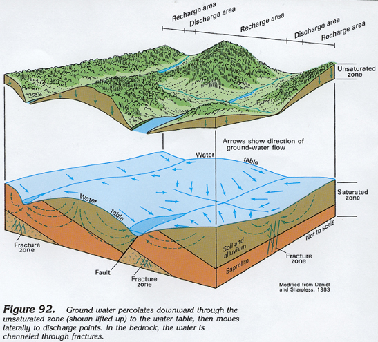
Water in the rocks of the Piedmont and Blue Ridge aquifers generally is unconfined. Locally, artesian conditions exist when wells penetrate deeply buried fractures that are hydraulically connected to recharge areas at higher altitudes or in places where the regolith is clayey and forms a confining unit. A generalized sketch showing ground-water movement in the unsaturated and saturated zones of the Piedmont and Blue Ridge aquifers is shown in figure 92. Water enters the ground in recharge areas, which generally include all the land surface except the lower parts of valleys, and percolates vertically downward through the unsaturated zone. Once the water reaches the saturated zone, or water table, it moves laterally to points of discharge. The water discharges as springs, seeps, baseflow to streams, and as seepage to lakes. The water table is a subdued replica of surface topography; thus, the depth to the water table varies, depending largely on topography and to a lesser extent on rainfall. On hills and steep ridges, the water table lies tens to hundreds of feet below land surface; the water table is at or near the land surface in valleys and adjacent to lakes, ponds, and wetlands. The dashed arrows in figure 92 show how water moves through the soil-and-alluvium and saprolite parts of the regolith. Water movement in the bedrock is restricted entirely to flow through fractures.
GROUND-WATER QUALITY
The quality of water from the Piedmont and Blue Ridge aquifers generally is suitable for drinking and other uses practically everywhere. Concentrations of dissolved constituents except for fluoride, iron, manganese, and, locally, sulfate seldom exceed State and Federal drinking-water standards. Wells yielding water containing large concentrations of these constituents possibly penetrate mineralized zones, although large iron concentrations may be due to the action of iron-fixing bacteria. Oxidation and filtration usually will alleviate problems of large iron and manganese concentrations, and render the water potable. Rarely, radioactive minerals occur in concentrations sufficient to create water-quality problems.
FRESH GROUND-WATER WITHDRAWALS
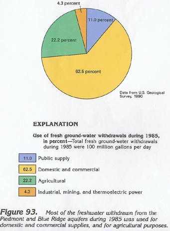
Total freshwater withdrawals from the Piedmont and Blue Ridge aquifers were estimated to be about 100 million gallons per day during 1985. About 11 million gallons per day was withdrawn for public supply (fig. 93). Most of the water pumped for public supply is withdrawn by small communities; larger cities and towns in the Piedmont and Blue Ridge physiographic provinces are supplied by surface water. About 63 million gallons per day was pumped for domestic and commercial uses, the principal uses. About 22 million gallons per day was withdrawn for agricultural purposes. About 4 million gallons per day was withdrawn for industrial, mining, and thermoelectric-power uses.