GROUND WATER ATLAS of the UNITED STATES
Idaho, Oregon, Washington
HA 730-H
Columbia Plateau regional aquifer system
There are two different files for each illustration
- A 90 ppi JPEG file, suitable for screen viewing is accessed
through the thumbnail image.
- A tiff file is accessed through the "tiff file"
link. All files are Adobe Photoshop. These files have been compressed
with GNU's gzip utility. If your web browser defaults to a screen
display of the file, turn on the "Load to local disk"
option before downloading. Download and process these tiff files
as ascii, not binary.
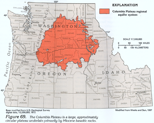
Figure 69 Map showing location of the
Columbia Plateau regional aquifer system (248K)
 downloadable
tiff file H069.tiff.gz (1.9MB
compressed)
downloadable
tiff file H069.tiff.gz (1.9MB
compressed)
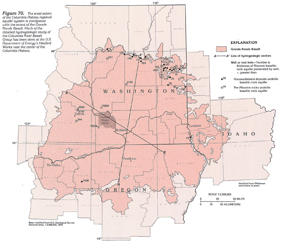
Figure 70 Map showing areal extent of the
Grande Ronde Basalt (204K)
 downloadable tiff
file H070.tif.gz (4.9MB compressed)
downloadable tiff
file H070.tif.gz (4.9MB compressed)
Figure 71 Cross-section showing unconsolidated-deposit
aquifers in the Columbia Plateau (176K)
 downloadable
tiff file H071.tif.gz (1.4MB
compressed)
downloadable
tiff file H071.tif.gz (1.4MB
compressed)
Figure 72 Cross-section of the
Columbia Plateau regional aquifer system (215K)
 downloadable
tiff file H072.tif.gz (1.4MB
compressed)
downloadable
tiff file H072.tif.gz (1.4MB
compressed)
Figure 73 Generalized cross-section of the
northwestern part of the Columbia Plateau regional aquifer system
(180K)
 downloadable
tiff file H073.tif.gz (1.3MB
compressed)
downloadable
tiff file H073.tif.gz (1.3MB
compressed)
Figure 74 Map showing thickness of the unconsolidated-deposit
aquifers (324K)
 downloadable
tiff file H074.tif.gz (2.6MB
compressed)
downloadable
tiff file H074.tif.gz (2.6MB
compressed)
Figure 75 Map showing estimated
hydraulic conductivity of the unconsolidated-deposit aquifers
(324K)
 downloadable
tiff file H075.tif.gz (2.6MB
compressed)
downloadable
tiff file H075.tif.gz (2.6MB
compressed)
Figure 76 Generalized section near the eastern
margin of the Columbia Plateau regional aquifer system (140K)
 downloadable
tiff file H076.tif.gz (1MB
compressed)
downloadable
tiff file H076.tif.gz (1MB
compressed)
Figure 77 Map showing thickness of the Wanapum
Basalt (316K)
 downloadable
tiff file H077.tif.gz (2.5MB
compressed)
downloadable
tiff file H077.tif.gz (2.5MB
compressed)
Figure 78 Map showing thickness of the Saddle
Mountains Basalt (300K)
 downloadable
tiff file H078.tif.gz (2.4MB
compressed)
downloadable
tiff file H078.tif.gz (2.4MB
compressed)
Figure 79 Map showing general direction
of ground-water movement in the Grande Ronde Basalt (244K)
 downloadable tiff
file H079.tif.gz (5.1MB compressed)
downloadable tiff
file H079.tif.gz (5.1MB compressed)
Figure 80
Map showing general direction of ground-water movement in
the Wanapum Basalt (244K)
 downloadable tiff
file H080.tif.gz (4.3MB compressed)
downloadable tiff
file H080.tif.gz (4.3MB compressed)
Figure 81 Map showing general direction
of ground-water movement in the Saddle Mountains Basalt (200K)
 downloadable tiff
file H081.tif.gz (3.3MB compressed)
downloadable tiff
file H081.tif.gz (3.3MB compressed)
Figure 82 Map showing predominant aquifers
in the Columbia Plateau regional aquifer system (284K)
 downloadable tiff
file H082.tif.gz (5.2MB compressed)
downloadable tiff
file H082.tif.gz (5.2MB compressed)
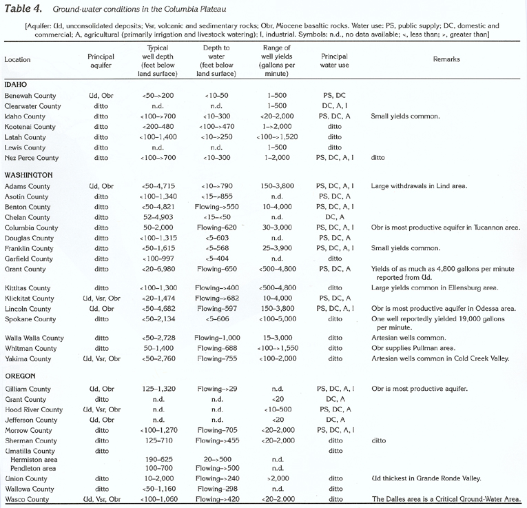
Table 4 Table showing ground-water conditions in the Columbia
Plateau (400K)
 downloadable
tiff file Htab4.tif.gz
(2.1MB compressed)
downloadable
tiff file Htab4.tif.gz
(2.1MB compressed)
Return to Columbia Plateau regional
aquifer system text
Return to HA 730-H table of contents
Return to Ground Water Atlas home page
 downloadable tiff
file H070.tif.gz (4.9MB compressed)
downloadable tiff
file H070.tif.gz (4.9MB compressed) 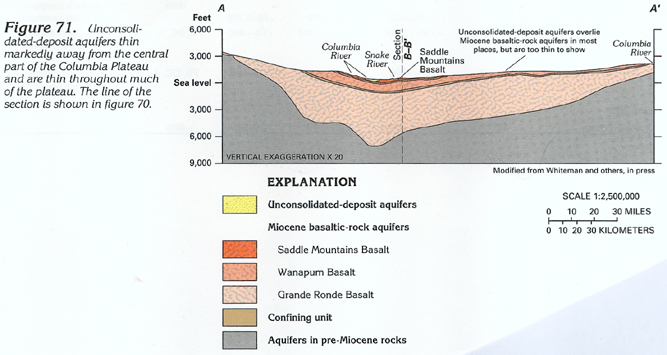 downloadable
tiff file H071.tif.gz (1.4MB
compressed)
downloadable
tiff file H071.tif.gz (1.4MB
compressed) 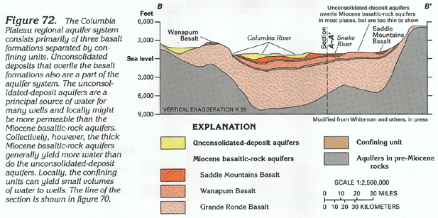 downloadable
tiff file H072.tif.gz (1.4MB
compressed)
downloadable
tiff file H072.tif.gz (1.4MB
compressed) 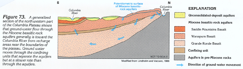 downloadable
tiff file H073.tif.gz (1.3MB
compressed)
downloadable
tiff file H073.tif.gz (1.3MB
compressed) 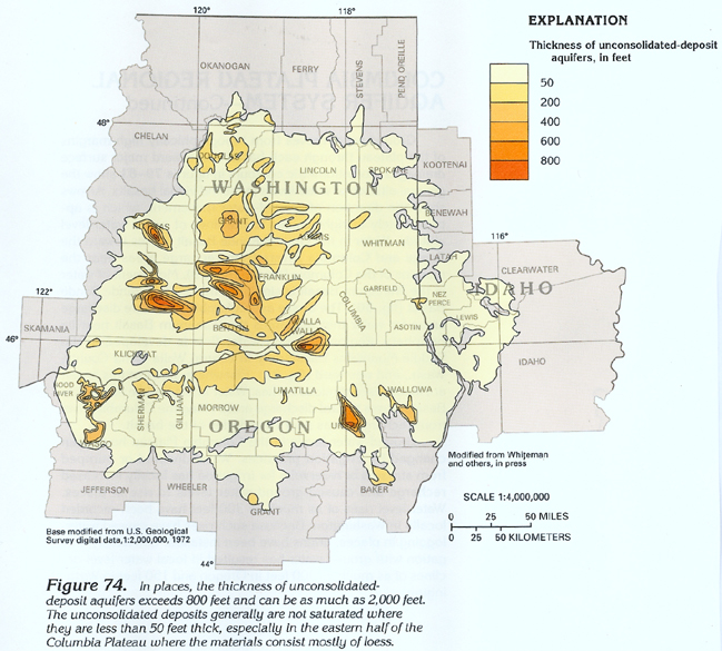 downloadable
tiff file H074.tif.gz (2.6MB
compressed)
downloadable
tiff file H074.tif.gz (2.6MB
compressed) 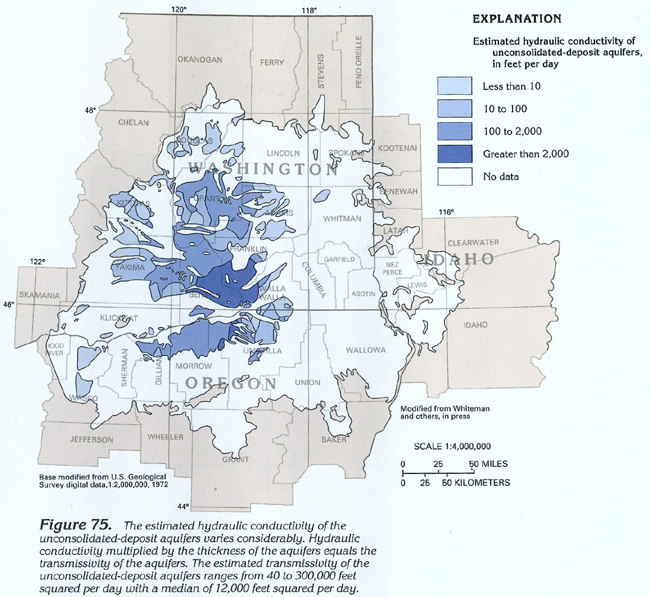 downloadable
tiff file H075.tif.gz (2.6MB
compressed)
downloadable
tiff file H075.tif.gz (2.6MB
compressed) 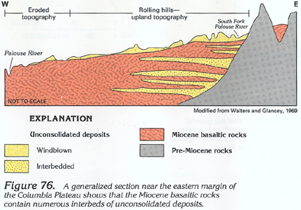 downloadable
tiff file H076.tif.gz (1MB
compressed)
downloadable
tiff file H076.tif.gz (1MB
compressed)  downloadable
tiff file H077.tif.gz (2.5MB
compressed)
downloadable
tiff file H077.tif.gz (2.5MB
compressed)  downloadable
tiff file H078.tif.gz (2.4MB
compressed)
downloadable
tiff file H078.tif.gz (2.4MB
compressed) 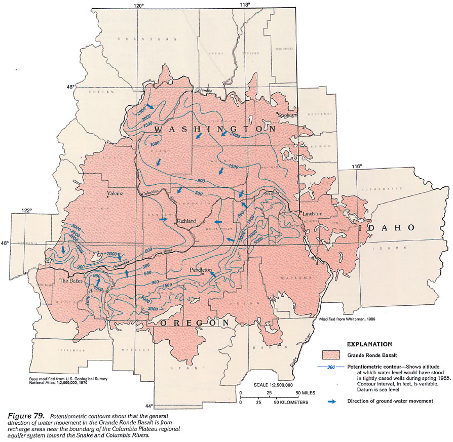 downloadable tiff
file H079.tif.gz (5.1MB compressed)
downloadable tiff
file H079.tif.gz (5.1MB compressed)  downloadable tiff
file H080.tif.gz (4.3MB compressed)
downloadable tiff
file H080.tif.gz (4.3MB compressed) 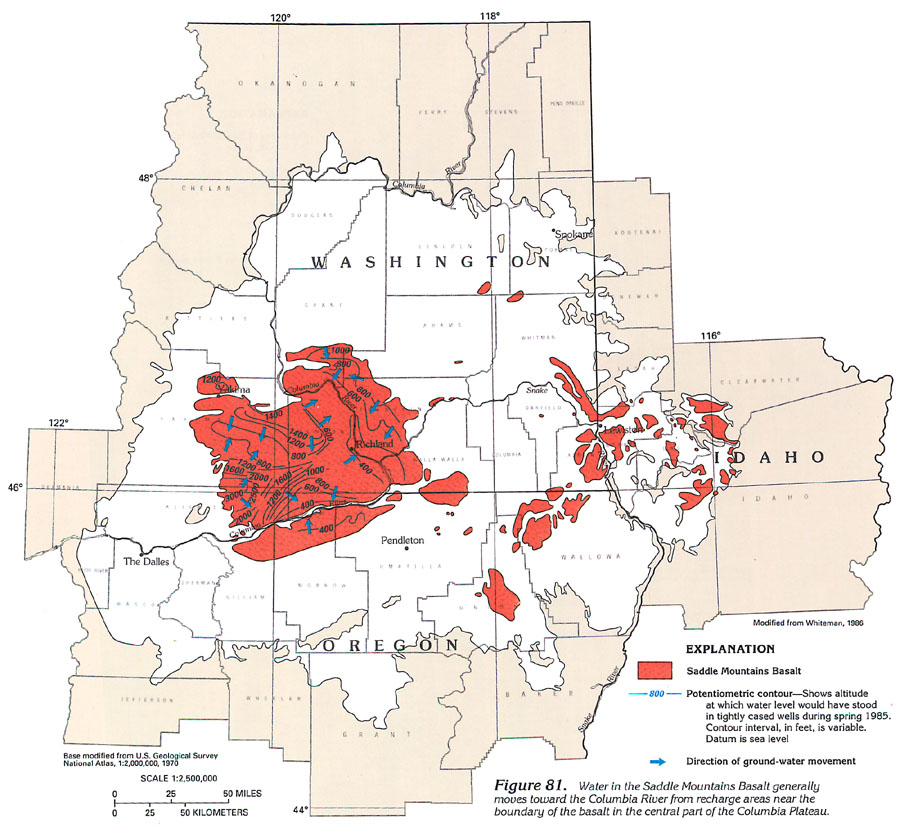 downloadable tiff
file H081.tif.gz (3.3MB compressed)
downloadable tiff
file H081.tif.gz (3.3MB compressed) 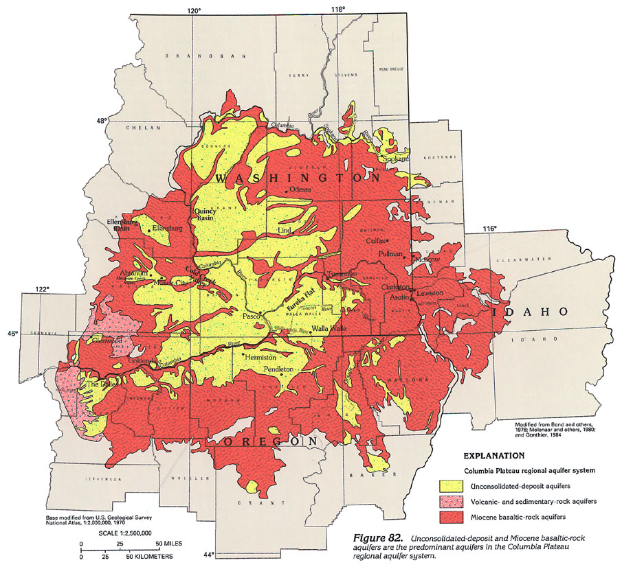 downloadable tiff
file H082.tif.gz (5.2MB compressed)
downloadable tiff
file H082.tif.gz (5.2MB compressed)
 downloadable
tiff file Htab4.tif.gz
(2.1MB compressed)
downloadable
tiff file Htab4.tif.gz
(2.1MB compressed)