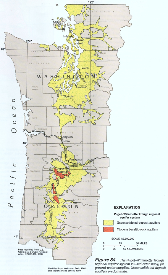
The Puget-Williamette Trough aquifer system underlies an elongated basin that extends southward from near the Canadian border in Washington to central Oregon (figs. 83 and 84). This basin contains the densest concentration of population and industry in Segment 7. The basin consists of three areas-the Puget Sound lowland in northern Washington, a central area that extends southward from the Puget Sound lowland to northern Oregon and includes part of the Columbia River Valley, and the Williamette River Valley, which extends southward from the Columbia River to central Oregon.
The major aquifers that compose the Puget-Williamette Trough regional aquifer system are unconsolidated-deposit and Miocene basaltic-rock aquifers. Unconsolidated-deposit aquifers are the principal aquifers in the Puget Sound lowland, whereas unconsolidated-deposit and Miocene basaltic-rock aquifers are the principal aquifers in the central area and the Williamette River Valley.
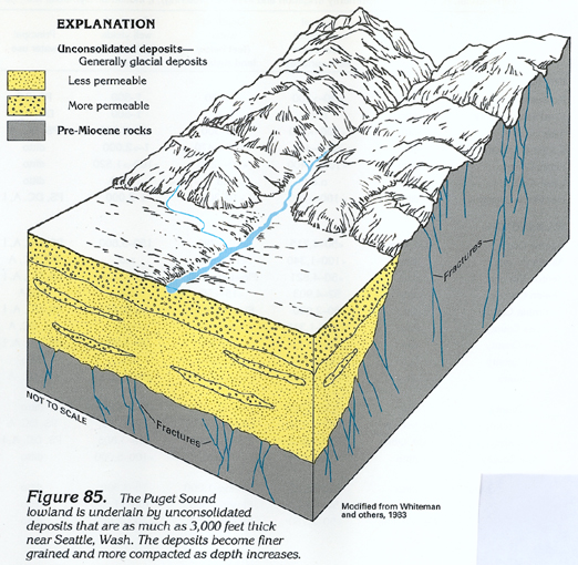
In the Puget Sound lowland, the unconsolidated-deposit aquifers consist chiefly of glacial deposits that are as much as 3,000 feet thick near Seattle, Wash. (fig. 85). Sand and gravel that were deposited during the last period of glaciation compose the most productive aquifers in the lowland and generally form the upper 200 to 300 feet of the unconsolidated deposits (fig. 85). At depth, sand and gravel deposits typically are discontinuous lenses that can be present as much as 2,000 feet below the land surface. Although usually much less permeable at depth because of compaction, lenses of sand and gravel can yield large volumes of water to wells. Even though well yields vary greatly, yields from sand and gravel aquifers commonly exceed 2,000 gallons per minute. Some public-supply and industrial wells in the Tacoma, Wash. area (fig. 84), that were completed in shallow sand and gravel of glacial origin, yield from 1,000 to 9,000 gallons per minute. Other public-supply wells that were completed in coarse-grained alluvial deposits along the Green River in King County, Wash., yield from 8,000 to 10,000 gallons per minute. Some artesian wells in the Seattle-Tacoma area that were completed in deeply buried lenses of sand and gravel yield from 150 to 1,700 gallons per minute.
In the southern and western parts of the Puget Sound lowland, glacial deposits are fine-grained, and the unconsolidated-deposit aquifers in these areas are much less productive than similar aquifers near Tacoma. Public-supply and irrigation wells in these areas generally yield from 50 to 750 gallons per minute.
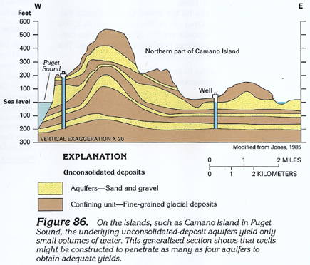
Residents of the islands in Puget Sound rely on ground-water supplies that have been obtained from unconsolidated-deposit and underlying aquifers, which are primarily in fractured consolidated sedimentary rocks of pre-Miocene age that yield little water. In places, the unconsolidated-deposit aquifers yield only small volumes of water, and wells are constructed to penetrate several aquifers to obtain adequate supplies of water (fig. 86).
Although numerous wells withdraw water from the unconsolidated-deposit aquifers in the Puget Sound lowland, only a small percentage of the total discharge from the aquifers is withdrawn by wells. Most ground water discharges from springs and seeps to streams that drain the lowland. Large springs discharge from 1,000 to 20,000 gallons per minute from some unconsolidated deposits that consist of glacial-outwash gravel. Some of these springs are sources of water for public supply; for example, the principal source of water for Olympia, Wash. (fig. 84), is a large spring that yields from 6,750 to 11,000 gallons per minute.
In the central area (fig. 84), natural discharge from unconsolidated-deposit and Miocene basaltic-rock aquifers is mostly toward the Columbia River. In this area, large volumes of water are withdrawn by wells in and near the Columbia River Valley. Large-diameter (as much as 36 inches) public-supply and industrial wells in Vancouver, Wash. (fig. 84), near the Columbia River yield as much as 4,500 gallons per minute from unconsolidated-deposit aquifers. Yields of 100 to 1,000 gallons per minute, however, are more common. Smaller diameter wells in the Vancouver area yield from 100 to 500 gallons per minute. Three springs that have a combined discharge of about 2,100 gallons per minute are used to supplement the public supply of Vancouver.
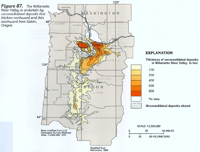
Along the Columbia River Valley and in the Willamette River Valley in Oregon, unconsolidated-deposit and Miocene basaltic-rock aquifers are the principal aquifers. Near Portland, Oreg., unconsolidated deposits are greater than 800 feet thick (fig. 87). Sand and gravel within these deposits (fig. 88) yield large volumes of water to wells. Some 36-inch-diameter wells, which supply water for Portland, yield as much as 10,000 gallons per minute from unconsolidated-deposit aquifers. Other public-supply and industrial wells completed in these aquifers commonly yield from 100 to 1,500 gallons per minute. Miocene basaltic-rock aquifers in the Portland area are about 1,500 feet thick. Yields from these aquifers range from less than 10 to 1,000 gallons per minute.
In the Willamette River Valley, unconsolidated deposits along
the axis of the valley thin gradually to a thickness of about
200 feet near Salem, Oreg. (fig. 87).
South of Salem, the unconsolidated deposits thin rapidly southward
and toward the margins of the valley; these deposits generally
are less than 100 feet thick (fig. 87).
On the western side of the Willamette River Valley in this area,
wells deeper than 100 feet usually penetrate consolidated pre-Miocene
sedimentary rocks that yield saltwater. Miocene basaltic-rock
aquifers that underlie the unconsolidated deposits in the eastern
side of the valley are the most productive aquifers.
A synopsis of some aspects of the ground-water system in the Puget-Willamette
Trough area (fig. 84) is presented
below:
· In the San Juan Islands, San Juan County, Wash., unconsolidated-deposit
aquifers are thin and discontinuous. Because most of these deposits
are fine grained, yields of wells completed in the deposits are
barely adequate for domestic and commercial and agricultural (primarily
livestock watering) supplies. The underlying pre-Miocene rocks
also yield little water. On some islands, several aquifers might
need to be penetrated by a well to obtain adequate supplies of
ground water. Intrusion of saltwater into freshwater aquifers
can be a problem.
· Because water levels have declined substantially in the
Cooper-Bull Mountain area on the western side of the Willamette
River Valley in Washington County, Oreg., the State has designated
this as a Critical Ground-Water Area.
· Because water levels have declined substantially in the
Salem Heights area east of Salem on the eastern side of the Willamette
River Valley in Marion County, Oreg., the State has designated
this as a Ground-Water Management Area.
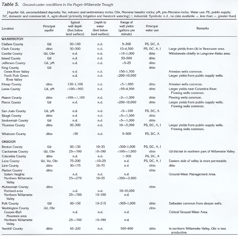
Information pertaining to ground-water conditions in the Puget-Willamette Trough is summarized by county in table 5.