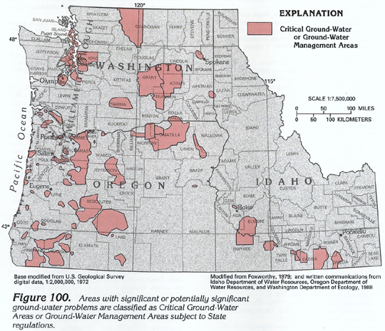
Long-term declines in ground-water levels are probably the most important ground-water problem in Idaho, Oregon, and Washington. In some places within Segment 7, long-term declines in ground-water levels have been intensified by free-flowing artesian wells that decrease the hydraulic pressure in aquifers and remove water from storage in the aquifers. Many of these wells discharge thousands of gallons of water per minute and are not constructed to shut off flow as required by State law. Where water levels have declined substantially, State water agencies have attempted to alleviate the problem by designating Critical Ground-Water Areas or Ground-Water Management Areas (fig. 100). In either type of area, further development is allowed only where withdrawals from new wells will not interfere with those from existing wells (fig. 101). Most long-term water-level declines are in volcanic- and sedimentary-rock aquifers in the arid and semiarid parts of Idaho, Oregon, and Washington. Some Ground-Water Management Areas in Oregon and Washington were so designated to alleviate and control water-quality problems.
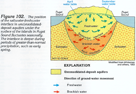
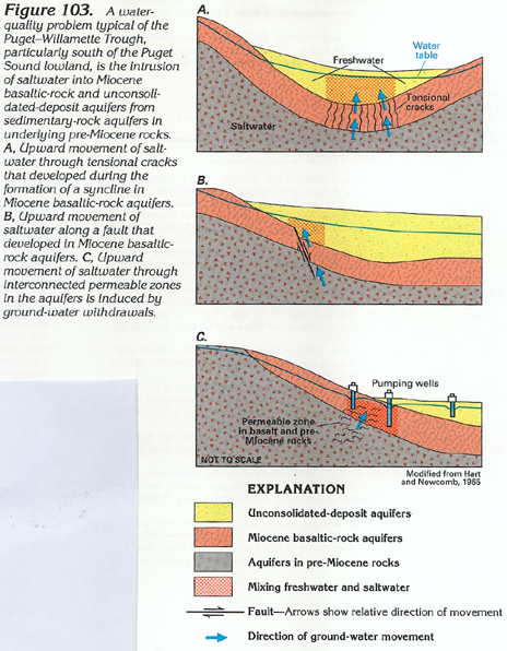
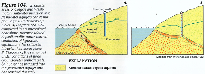
Ground-water quality problems in Segment 7 include the fluctuation of the freshwater-saltwater interface beneath the land surface on the islands in Puget Sound (fig. 102), the intrusion of saltwater into freshwater aquifers in the Puget-Willamette Trough (fig. 103), the intrusion of saltwater into freshwater aquifers in coastal areas of Oregon and Washington (fig. 104), and the contamination of freshwater aquifers by geothermal water in Idaho and Oregon. Locally, freshwater aquifers have been contaminated by human activities in some parts of Segment 7.
Where permeable zones, such as the sand and gravel lenses in unconsolidated-deposit aquifers that underlie the islands in Puget Sound, are hydraulically connected to the Sound, movement of saltwater into the aquifers is naturally prevented by a column of freshwater (fig. 102). Because freshwater is lighter than saltwater, a column of freshwater that is 41 feet high is necessary to balance a column of saltwater that is 40 feet high. The result is that for each foot of freshwater above sea level, there is a column of freshwater about 40 feet thick below sea level. Lowering the freshwater column by decreasing precipitation or by increasing ground-water withdrawals or both results in saltwater rising to a higher altitude. Such a condition is shown by the position of the late summer interface (fig. 102), which corresponds to a time when the water table is lower. As the water table rises in response to precipitation in the spring, the freshwater column becomes higher, and the saltwater interface is simultaneously lowered. Incomplete flushing of the saltwater during this lowering could create a zone of brackish water in the aquifer. A similar situation is applicable in the coastal areas of Oregon and Washington.
In the Puget-Willamette Trough, particularly south of the Puget Sound lowland, saltwater can intrude into freshwater aquifers under a variety of conditions (fig. 103). The conditions that are illustrated in figure 103A and B can be intensified by the installation of wells within or near the zone of mixing, as illustrated in figure 103C. The intrusion of saltwater can be minimized by careful monitoring of (1) well construction by installing shallow wells that skim the uppermost freshwater and (2) the magnitude and timing of ground-water withdrawals by allowing maximum withdrawals only during periods of maximum recharge.
In coastal areas of Oregon and Washington, hydrologic conditions (fig. 104) are similar to those on the islands in Puget Sound (fig. 102). In the coastal areas, the extent of saltwater intrusion is determined primarily by the magnitude of ground-water withdrawals. As in the Puget-Willamette Trough, intrusion of saltwater into coastal areas can be minimized by careful design and placement of wells and careful monitoring of the magnitude and timing of ground-water withdrawals.
Excessive concentrations of certain dissolved minerals in geothermal water pose water-quality problems. The most common of these minerals are dissolved fluoride, arsenic, and iron. Concentrations of dissolved fluoride in excess of 4 milligrams per liter can cause mottling of teeth, especially children's, and can cause bones to become brittle. Dissolved iron is not detrimental to human health, but concentrations in excess of 200 micrograms per liter can cause staining of kitchen and bathroom fixtures and can cause clogging of well-screen openings and pumps. Concentrations of dissolved arsenic in excess of 30 micrograms per liter are toxic to humans.
Although generally of local extent, degradation of ground-water quality by human activities is more widespread and of greater consequence than are the naturally occurring water-quality problems. Ground water underlying the irrigated areas can contain greater-than-background concentrations of dissolved minerals because of increased salts, which are caused by evaporation of applied irrigation water. Large concentrations of chloride, nitrate, sulfate, and residue from fertilizers and pesticides applied to the land might reach the water table as irrigation water percolates downward. Ground water at and in the vicinity of abandoned and active landfills and other hazardous waste sites might be degraded by leachates that originated in the disposed material. Methane in explosive concentrations also might be entering the ground-water system at such sites. Chemicals in return water that is used for cooling and heating are potential contaminants of ground water. In addition, return-water temperature might differ substantially from the temperature of the water in the aquifer and cause adverse chemical reactions in the aquifer. Many wells are subject to intermittent contamination problems because of improper sealing around the well casing at the land surface.
Another local ground-water problem is waterlogging. Waterlogging
has developed in some areas because of excess application of irrigation
water obtained from surface-water sources. In other areas, natural
waterlogging problems have been intensified by irrigation practices.