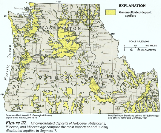
Unconsolidated-deposit aquifers (fig. 22), which consist primarily of sand and gravel, are the most productive and widespread aquifers in Idaho, Oregon, and Washington. These aquifers are prevalent along present and ancestral stream valleys and in lowlands that are associated with structural or erosional basins. These unconsolidated-deposit aquifers provide freshwater for most public-supply, domestic, commercial, and industrial purposes. They also are important sources of water for agricultural (primarily irrigation) purposes in many parts of Segment 7. The unconsolidated deposits are mostly alluvial deposits, but in places, they consist of eolian, glacial, or volcanic deposits. Alluvial deposits consist primarily of well-sorted particles that range in size from clay to boulders. The finer particles-clay and silt-generally form confining units, whereas the coarser particles-primarily sand and gravel with some cobbles and boulders-form productive aquifers. Eolian deposits, or loess, consist chiefly of clay, silt, and fine sand. Although loess is well sorted, it does not form productive aquifers because it is fine grained, usually unsaturated, and commonly is only a veneer overlying other rocks. Glacial deposits consist chiefly of mixtures of particles that range in size from clay to boulders. These deposits can be either well sorted where they were deposited by glacial meltwater (glacial outwash) or unsorted where they were deposited at the margins of the ice (glacial till). Where these deposits are well sorted, they form productive aquifers. Volcanic deposits consist chiefly of ash and basaltic sand, particularly in southwestern Idaho and southeastern Oregon. These deposits, which commonly are interbedded with thin flows of basalt and welded tuff, generally have minimal permeability and do not form productive aquifers.
Typically, unconsolidated deposits along stream valleys consist chiefly of sand and gravel that form productive aquifers. The thickness of the deposits along present stream valleys commonly is less than 250 feet. Many of these aquifers are not shown in figure 22 because of the scale of the map.
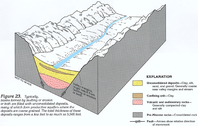
Basins filled with unconsolidated deposits (fig. 23) were formed by faulting or erosion or both. Thick sequences of unconsolidated deposits that have variable permeability are common in these basins (fig. 24). In some basins, these deposits might be as much as 5,500 feet thick. Where thick sequences of these deposits are present, the uppermost 500 feet generally is the most permeable because the deposits are increasingly compacted with depth. The volume of water stored in the deposits and the permeability of the deposits depend primarily on the parent rock type. Basins in areas where the bedrock consists of volcanic, igneous, and metamorphic rocks typically contain extremely permeable aquifers that consist of coarse sand, gravel, and cobbles that were eroded from the parent rocks, whereas basins in areas where the bedrock consists of consolidated sedimentary rocks of marine origin, such as limestone, dolomite, and shale, typically contain much less permeable clay, silt, and fine sand that was eroded from the parent rocks. In both types of basins, the deposits typically are coarser grained near the margins of the basins and finer grained near the center of the basins.
Permeability of the unconsolidated deposits is variable; sand and gravel commonly yield from 20 to 2,000 gallons per minute to wells. Coarser deposits along major streams and deposits of glacial outwash yield from 500 to 2,500 gallons per minute to wells that penetrate from 50 to 150 feet of saturated deposits. Fine-grained deposits commonly yield from 1 to 100 gallons per minute depending on the percentage of clay. Unconsolidated deposits in closed basins in southeastern Oregon are typically fine grained and yield from 1 to 200 gallons per minute. Segmentwide, the specific capacity (the volume of water a well will yield per foot of drawdown in the well) of wells completed in unconsolidated deposits ranges from less than 5 to 1,000 gallons per minute per foot of drawdown. Public-supply wells completed in glacial outwash in Washington reportedly yield as much as 10,000 gallons per minute in the Puget Sound area and 19,000 gallons per minute in the Spokane Valley. The ability of this type of aquifer to yield water usually decreases with depth as the unconsolidated deposits become progressively finer grained and compacted. In some basins, however, the unconsolidated deposits might be underlain by volcanic rocks that are more permeable than the unconsolidated deposits.
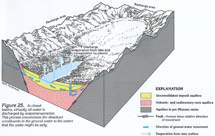
The unconsolidated-deposit aquifers generally yield freshwater but locally yield saltwater, especially in south-central Oregon and in coastal areas. In south-central Oregon, the salt-water generally is the result of evaporation of surface and ground water in closed basins (fig. 25), which concentrates the dissolved constituents in the remaining water. In coastal areas, the saltwater is the result of induced movement of saltwater from the ocean or other saltwater bodies into the freshwater aquifers; this movement often is caused by large withdrawals from wells. Because saltwater is denser than freshwater, saltwater contamination is restricted to the basal part of the freshwater aquifers. Where such saltwater contamination has occurred, the adverse effects can be mitigated either by discontinuing withdrawals or by adjusting withdrawal depths or rates or both, so that, in effect, freshwater is "skimmed" from the top part of the aquifers.