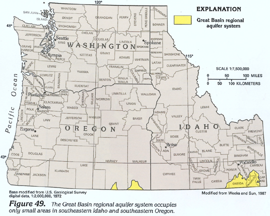
Only small parts of the Great Basin regional aquifer system are present in southeastern Idaho and southeastern Oregon (fig. 49). In southeastern Idaho, the aquifer system consists primarily of unconsolidated-deposit aquifers (chiefly sand and gravel) that overlie volcanic- and sedimentary-rock aquifers (chiefly Pliocene and younger basaltic rocks) in basins, and aquifers in pre-Miocene rocks (chiefly carbonate rocks) that form mountain ranges between the basins (figs. 50 and 51); locally, Pliocene and younger and Miocene basaltic-rock aquifers are present along or near the northern margins of the aquifer system (fig. 51). Generally, there is an areally extensive confining unit between the unconsolidated-deposit aquifers and the underlying volcanic- and sedimentary-rock aquifers (fig. 50); local confining units are present in all the deposits and the rocks. In southeastern Oregon, the aquifer system consists primarily of volcanic- and sedimentary-rock and Miocene basaltic-rock aquifers; unconsolidated-deposit aquifers are present along the eastern margin of the easternmost area. Little is known about the aquifer system in the two areas of southeastern Oregon because these areas are sparsely populated, and ground-water use is minimal. For these reasons, subsequent discussions of the Great Basin regional aquifer system pertain primarily to southeastern Idaho, where development of the aquifer system for freshwater supplies has been extensive. In this report, aquifers that are present in unconsolidated deposits and in Pliocene and younger basaltic rocks in Bear Lake and Caribou Counties in Idaho are hydrologically similar to and are discussed with aquifers of the Great Basin regional aquifer system (fig. 51).
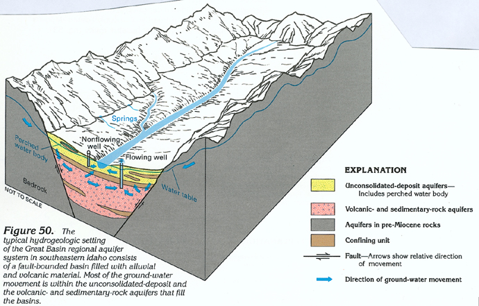
Recharge to the aquifer system is from precipitation, primarily snow falling on the mountain ranges. Snowmelt flows down the steep mountain fronts, and much of it either infiltrates unconsolidated deposits that form alluvial fans adjacent to many mountain fronts (fig. 50) or moves as overland runoff to small streams tributary to the principal stream that is present in each basin. Some snowmelt infiltrates Pliocene and younger basaltic-rock aquifers that are most common in Caribou County, Idaho, and some snowmelt infiltrates aquifers in the pre-Miocene rocks that form the mountain ranges. Tributary streams typically lose much of their flow by infiltration into the alluvial fans as the streams cross mountain-front slopes. Alternating fine- and coarse-grained layers in the alluvial fans result in perched water conditions in many places (fig. 50).
Water movement in the unconsolidated-deposit aquifers is primarily toward the principal stream flowing through each basin and toward wells completed in the aquifers (fig. 50); water movement in the Pliocene and younger basaltic-rock aquifers is similar to that in the unconsolidated-deposit aquifers. Because confined conditions are common in both types of aquifers, wells completed in the aquifers commonly flow at the land surface. Some water in the unconsolidated-deposit aquifers moves downward through confining units into the underlying volcanic- and sedimentary-rock aquifers (fig. 50). Water movement in the volcanic- and sedimentary-rock aquifers is primarily toward wells completed in the aquifers. Because of the confined conditions in these aquifers, the wells typically flow at the land surface. Virtually all water movement in aquifers in pre-Miocene rocks is toward the basins. Some of this water is discharged by large springs and sustains the flow in tributary streams.
Discharge from the aquifer system is primarily by evapotranspiration, inflow to streams, spring flow, and withdrawals from wells. Well yields range from about 1 to about 3,400 gallons per minute. Most wells are completed in either the unconsolidated-deposit or the Pliocene and younger basaltic-rock aquifers.
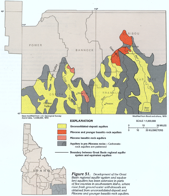
Development of the Great Basin regional aquifer system and
equivalent aquifers within Segment 7 has been most extensive in
parts of five counties in southeastern Idaho (fig.
51). A synopsis of some aspects of the ground-water system
in the Great Basin regional aquifer system and equivalent aquifers
in Idaho, by county, is presented below:
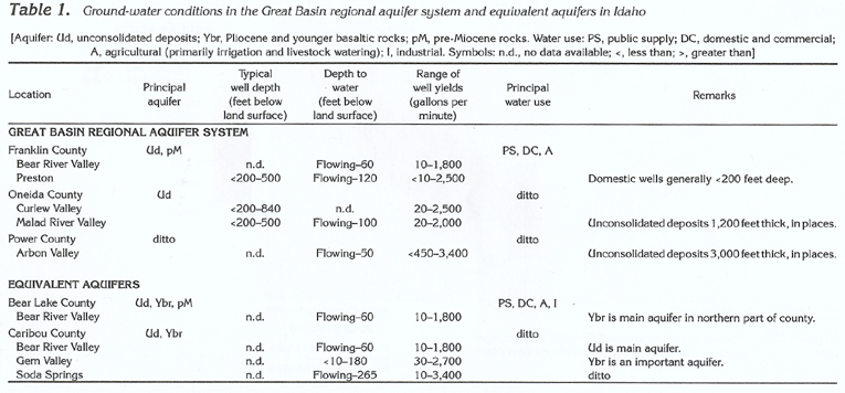
· In Bear Lake County, development is concentrated in the
Bear River Valley. Most water is obtained from unconsolidated-deposit
(most of the valley) and Pliocene and younger basaltic-rock (northern
part of the valley) aquifers. Flowing wells are common; the depth
to water in nonflowing wells is about 60 feet. Well yields range
from about 10 to about 1,800 gallons per minute, and the water
from all aquifers is fresh. Fresh ground-water withdrawals are
used primarily for public-supply, domestic and commercial, agricultural
(primarily irrigation and livestock watering), and industrial
purposes.
· In Caribou County, development is concentrated in the
Bear River Valley, Gem Valley, and the Soda Springs area. In the
Bear River Valley, most water is obtained from unconsolidated-deposit
aquifers. Flowing wells are common; the depth to water in nonflowing
wells is about 60 feet. Well yields range from about 10 to about
1,800 gallons per minute. In Gem Valley, most water is obtained
from Pliocene and younger basaltic-rock aquifers. The depth to
water in wells ranges from about 10 to about 180 feet. Well yields
range from about 30 to about 2,700 gallons per minute. In the
Soda Springs area, most water is obtained from Pliocene and younger
basaltic-rock aquifers. Flowing wells are common; the depth to
water in nonflowing wells is about 265 feet. Well yields range
from about 10 to about 3,400 gallons per minute, and the water
from all aquifers is fresh. Fresh ground-water withdrawals are
used primarily for public-supply, domestic and commercial, agricultural
(primarily irrigation and livestock watering), and industrial
purposes.
· In Franklin County, development is concentrated in the
Bear River Valley and in the Preston area. In the Bear River Valley,
most water is obtained from unconsolidated-deposit aquifers. Flowing
wells are common; the depth to water in nonflowing wells is about
60 feet. Well yields range from about 10 to about 1,800 gallons
per minute. In the Preston area, most water also is obtained from
unconsolidated-deposit aquifers. Domestic wells generally are
less than 200 feet deep, whereas large-capacity wells generally
are from 200 to 500 feet deep. Flowing wells are common; the depth
to water in nonflowing wells is about 120 feet. Well yields range
from about 10 to about 2,500 gallons per minute, and the water
is fresh. Fresh ground-water withdrawals are used primarily for
public-supply, domestic and commercial, and agricultural (primarily
irrigation and livestock watering) purposes.
· In Oneida County, development is concentrated in the
Malad River Valley and the Curlew Valley. In the Malad River Valley,
springs and seeps discharge large volumes of water from unconsolidated-deposit
aquifers. About 300 flowing wells yield a total of about 8,000
gallons per minute, primarily from unconsolidated-deposit aquifers;
the unconsolidated deposits are known to be as much as 1,200 feet
thick in places. Wells generally are from about 200 to about 500
feet deep; the depth to water in nonflowing wells is about 100
feet. Well yields range from about 20 to about 2,000 gallons per
minute. In Curlew Valley, most water is obtained from unconsolidated-deposit
aquifers. Wells generally are from about 200 to about 840 feet
deep. Well yields range from about 20 to about 2,500 gallons per
minute, and the water from all aquifers is fresh. Fresh ground-water
withdrawals are used primarily for public-supply, domestic and
commercial, and agricultural (primarily irrigation and livestock
watering) purposes.
· In Power County, development is concentrated in Arbon
Valley. Most water is obtained from unconsolidated-deposit aquifers;
unconsolidated deposits are known to be as much as about 3,000
feet thick in places. Flowing wells are common; the depth to water
in nonflowing wells is about 50 feet. Well yields range from about
450 to about 3,400 gallons per minute, and the water is fresh.
Fresh ground-water withdrawals are used primarily for public-supply,
domestic and commercial, and agricultural (primarily irrigation
and livestock watering) purposes.
Information pertaining to ground-water conditions in the Great Basin regional aquifer system and equivalent aquifers in Idaho is summarized by county in table 1.