GROUND WATER ATLAS of the UNITED STATES
Montana, North Dakota, South Dakota, Wyoming
HA 730-I
Regional aquifer systems
There are two different files for each illustration
- A 72 ppi GIF file, suitable for screen viewing is accessed through
the thumbnail image
- An eps file, suitable for downloading to be printed or edited is accessed
through the "eps file" link. Most files are Adobe Illustrator
6.0, exceptions are noted. These files have been compressed with GNU's
gzip utility. If your web browser defaults to a screen display of the file,
turn on the "Load to local disk" option before downloading. Download
and process these eps files as ascii, not binary.
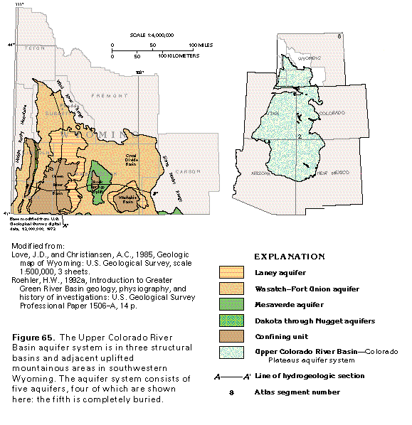
Upper Colorado River Basin aquifer system
Figure 65 Map of the aquifer system (33K)
 editable eps
file I065.eps.gz (330K compressed)
editable eps
file I065.eps.gz (330K compressed)
Figure 66 Correlation chart (33K)
 editable eps
file I066.eps.gz (116K compressed)
editable eps
file I066.eps.gz (116K compressed)
Figure 67 Diagramatic section of the aquifer system
(50K)
 editable eps
file I067.eps.gz (83K compressed)
editable eps
file I067.eps.gz (83K compressed)
Figure 68 Map showing approximate depth to water in the aquifer
system (17K)
 editable eps
file I068.eps.gz (149K compressed)
editable eps
file I068.eps.gz (149K compressed)
Figure 69 Map of potentiometric contours in the Wasatch-Fort
Union aquifer (17K)
 editable eps
file I069.eps.gz (99K compressed)
editable eps
file I069.eps.gz (99K compressed)
Figure 70 Map of dissolved-solids concentration in water
from Mesaverde aquifer (33K)
 editable eps
file I070.eps.gz (132K compressed)
editable eps
file I070.eps.gz (132K compressed)
Figure 71 Map showing depth to top of Paleozoic rocks
(33K)
 editable eps
file I071.eps.gz (83K compressed)
editable eps
file I071.eps.gz (83K compressed)
Figure 72 Map of potentiometric contours in the Pennsylvanian
aquifer (17K)
 editable eps
file I072.eps.gz (83K compressed)
editable eps
file I072.eps.gz (83K compressed)
Figure 73 Map of potentiometric contours in the Mississippian
aquifer (17K)
 editable eps
file I073.eps.gz (83K compressed)
editable eps
file I073.eps.gz (83K compressed)
 editable eps
file I065.eps.gz (330K compressed)
editable eps
file I065.eps.gz (330K compressed) 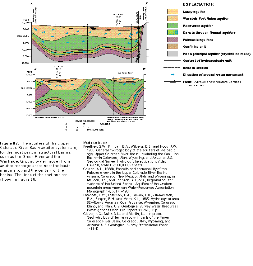 editable eps
file I067.eps.gz (83K compressed)
editable eps
file I067.eps.gz (83K compressed) 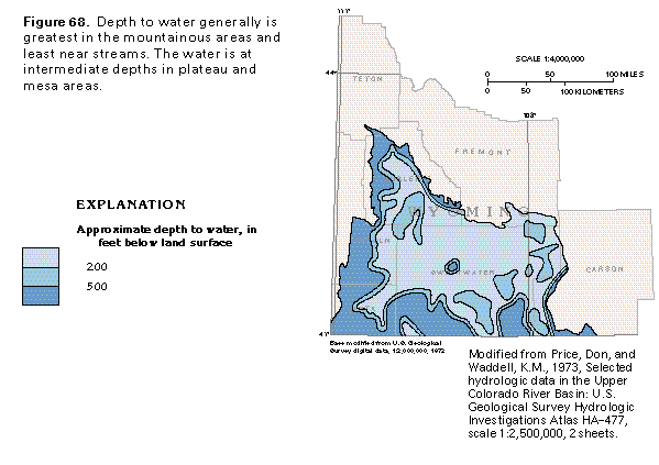 editable eps
file I068.eps.gz (149K compressed)
editable eps
file I068.eps.gz (149K compressed) 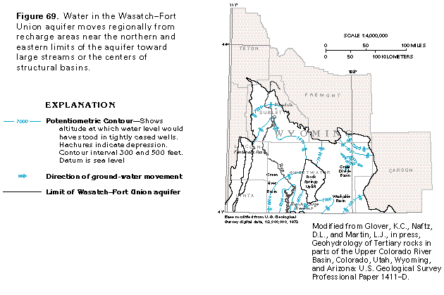 editable eps
file I069.eps.gz (99K compressed)
editable eps
file I069.eps.gz (99K compressed) 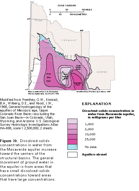 editable eps
file I070.eps.gz (132K compressed)
editable eps
file I070.eps.gz (132K compressed) 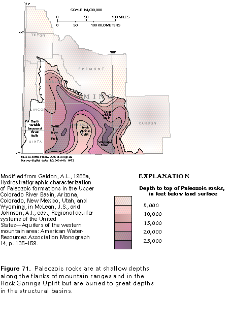 editable eps
file I071.eps.gz (83K compressed)
editable eps
file I071.eps.gz (83K compressed) 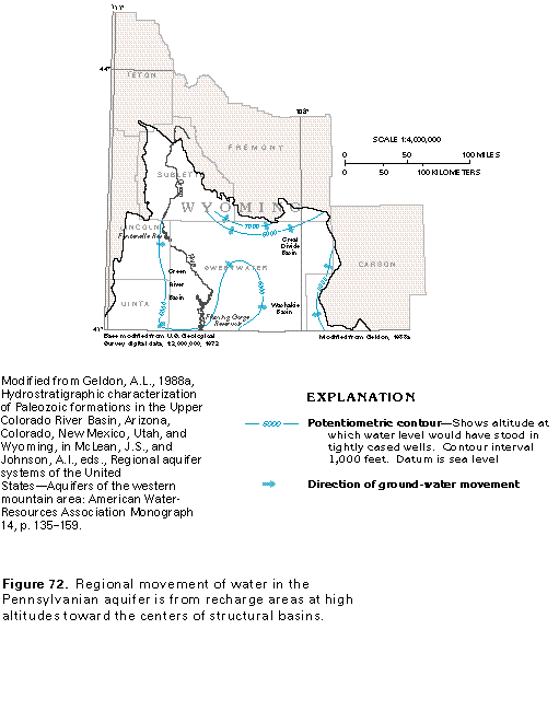 editable eps
file I072.eps.gz (83K compressed)
editable eps
file I072.eps.gz (83K compressed) 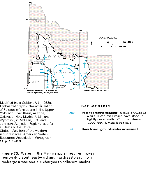 editable eps
file I073.eps.gz (83K compressed)
editable eps
file I073.eps.gz (83K compressed)