GROUND WATER ATLAS of the UNITED STATES
Montana, North Dakota, South Dakota, Wyoming
HA 730-I
Regional summary
There are two different files for each illustration
- A 72 ppi GIF file, suitable for screen viewing is accessed through
the thumbnail image
- An eps file, suitable for downloading to be printed or edited is accessed
through the "eps file" link. Most files are Adobe Illustrator
6.0, exceptions are noted. These files have been compressed with GNU's
gzip utility. If your web browser defaults to a screen display of the file,
turn on the "Load to local disk" option before downloading. Download
and process these eps files as ascii, not binary.
Ground-water occurrence and movement
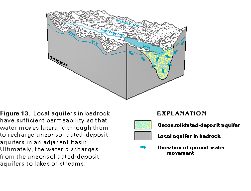
Figure 13 Diagram of water movement through local aquifers in bedrock
(17K)
 This illustration contains
a placed image. Download the Adobe Illustrator 6 eps
file I013.eps.gz (132K compressed) which contains an imbedded Adobe
Photoshop 3 (eps) file. You may also want to download the editable
Photoshop file I013psh.eps.gz (99K compressed)
This illustration contains
a placed image. Download the Adobe Illustrator 6 eps
file I013.eps.gz (132K compressed) which contains an imbedded Adobe
Photoshop 3 (eps) file. You may also want to download the editable
Photoshop file I013psh.eps.gz (99K compressed)
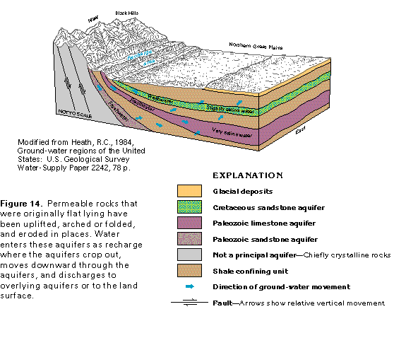
Figure 14 Diagram of permeable rock aquifers (33K)
 This illustration contains
a placed image. Download the Adobe Illustrator 6 eps
file I014.eps.gz (231K compressed) which contains an imbedded Adobe
Photoshop 3 (eps) file. You may also want to download the editable
Photoshop file I014psh.eps.gz (165K compressed)
This illustration contains
a placed image. Download the Adobe Illustrator 6 eps
file I014.eps.gz (231K compressed) which contains an imbedded Adobe
Photoshop 3 (eps) file. You may also want to download the editable
Photoshop file I014psh.eps.gz (165K compressed)
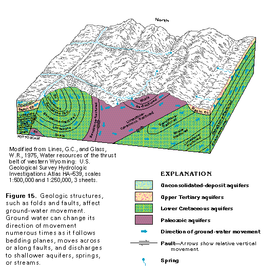
Figure 15 Diagram of geologic structures affecting ground-water
movement (33K)
 This illustration contains
a placed image. Download the Adobe Illustrator 6 eps
file I015.eps.gz (363K compressed) which contains an imbedded Adobe
Photoshop 3 (eps) file. You may also want to download the editable
Photoshop file I015psh.eps.gz (281K compressed)
This illustration contains
a placed image. Download the Adobe Illustrator 6 eps
file I015.eps.gz (363K compressed) which contains an imbedded Adobe
Photoshop 3 (eps) file. You may also want to download the editable
Photoshop file I015psh.eps.gz (281K compressed)
 This illustration contains
a placed image. Download the Adobe Illustrator 6 eps
file I013.eps.gz (132K compressed) which contains an imbedded Adobe
Photoshop 3 (eps) file. You may also want to download the editable
Photoshop file I013psh.eps.gz (99K compressed)
This illustration contains
a placed image. Download the Adobe Illustrator 6 eps
file I013.eps.gz (132K compressed) which contains an imbedded Adobe
Photoshop 3 (eps) file. You may also want to download the editable
Photoshop file I013psh.eps.gz (99K compressed)