GROUND WATER ATLAS of the UNITED STATES
Montana, North Dakota, South Dakota, Wyoming
HA 730-I
Regional summary
There are two different files for each illustration
- A 72 ppi GIF file, suitable for screen viewing is accessed through
the thumbnail image
- An eps file, suitable for downloading to be printed or edited is accessed
through the "eps file" link. Most files are Adobe Illustrator
6.0, exceptions are noted. These files have been compressed with GNU's
gzip utility. If your web browser defaults to a screen display of the file,
turn on the "Load to local disk" option before downloading. Download
and process these eps files as ascii, not binary.
Water-level fluctuations
Short-term fluctuations
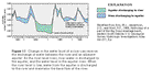
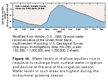
Figure 16 Graph showing water level change as a result of irrigation,
1966 (17K)
 editable eps
file I016.eps.gz (17K compressed)
editable eps
file I016.eps.gz (17K compressed)
Figure 17 Graph showing water exchange between a river and
an adjacent aquifer (17K)
 editable eps
file I017.eps.gz (17K compressed)
editable eps
file I017.eps.gz (17K compressed)
Figure 18 Graphs of water level below land surface and ground-water
withdrawals (17K)
 editable eps
file I018.eps.gz (17K compressed)
editable eps
file I018.eps.gz (17K compressed)
Long-term fluctuations
Figure 19 Graph showing correlation between long-term ground-water
levels and precipitation (17K)
 editable eps
file I019.eps.gz (17K compressed)
editable eps
file I019.eps.gz (17K compressed)
Figure 20 Graph showing uncontrolled flow from an artesian
aquifer (17K)
 editable eps
file I020.eps.gz (17K compressed)
editable eps
file I020.eps.gz (17K compressed)
 editable eps
file I016.eps.gz (17K compressed)
editable eps
file I016.eps.gz (17K compressed) 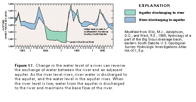 editable eps
file I017.eps.gz (17K compressed)
editable eps
file I017.eps.gz (17K compressed) 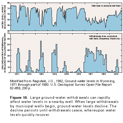 editable eps
file I018.eps.gz (17K compressed)
editable eps
file I018.eps.gz (17K compressed) 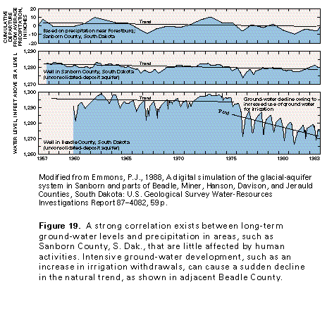 editable eps
file I019.eps.gz (17K compressed)
editable eps
file I019.eps.gz (17K compressed) 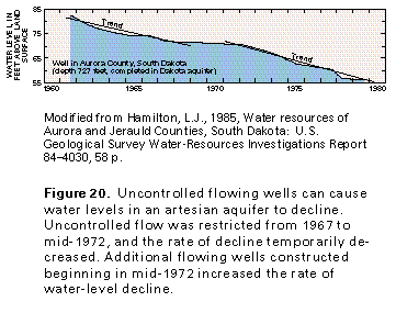 editable eps
file I020.eps.gz (17K compressed)
editable eps
file I020.eps.gz (17K compressed)