PRINCIPAL AQUIFERS
VOLCANIC- AND SEDIMENTARY-ROCK AQUIFERS
Volcanic- and sedimentary-rock aquifers are in small areas of northwestern Wyoming and southwestern Montana (fig. 25). These aquifers are complexly interbedded and consist of extrusive igneous rocks (primarily basalt and rhyolite), beds of tuff and volcanic ash, and beds of semiconsolidated to consolidated sedimentary rocks that contain large to small amounts of volcanic material. Locally, sand and gravel deposited as outwash from alpine glaciers or alluvial deposits in stream valleys overlie the volcanic and sedimentary rocks and are in direct hydraulic connection with them. The permeability of the volcanic- and sedimentary-rock aquifers is extremely variable because they are complexly interbedded and consist of numerous rock types. In some places, permeability is high, as indicated by the large springs that issue from these aquifers; in most places, however, the aquifers yield only enough water to supply domestic wells. The aquifers extend over only a small part of Segment 8 and are mostly within the boundaries of Yellowstone National Park. Accordingly, the potential to develop these aquifers in the segment is lacking. The volcanic- and sedimentary-rock aquifers are much more extensive and important as a source of freshwater in Segment 7 to the west and are discussed in detail in Chapter H of this Atlas.
UNCONSOLIDATED-DEPOSIT AQUIFERS
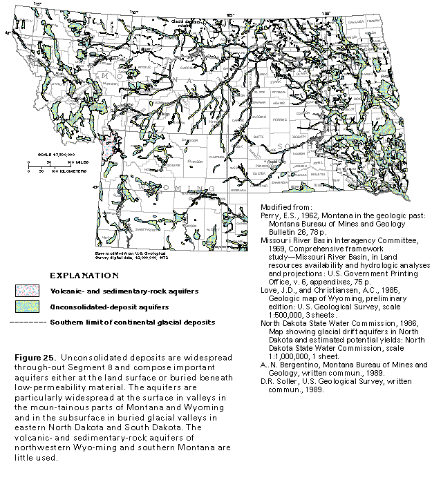
Unconsolidated-deposit aquifers (fig. 25) in sediments of Quaternary age are the most productive aquifers in Segment 8 and are the source of water for thousands of shallow wells. These aquifers consist primarily of sand and gravel but locally contain cobbles and boulders. Commonly, the aquifers contain clay and silt either mixed with the sand and gravel or as beds or lenses; where bedded, the clay and silt form confining units. The unconsolidated-deposit aquifers are important sources of water for all use categories in the four-State area and are in the following settings:
· A broad band of continental glacial deposits in Montana, North Dakota, and South Dakota
· Narrow valleys along major streams, primarily in southeastern Montana and locally in southwestern North Dakota, western South Dakota, and northeastern Wyoming
· Broad valleys in structural or erosional basins in western Montana and central, southern, and western Wyoming
The sediments that compose the unconsolidated-deposit aquifers were deposited as outwash from continental and alpine, or mountain, glaciers and as alluvium from streams. Because of the wide range of depositional environments, the aquifers have a wide range of permeability. Sand and gravel that make up alluvial deposits and glacial outwash generally are extremely permeable, whereas fine-grained lake deposits and poorly-sorted till have minimal permeability and commonly form local confining units.
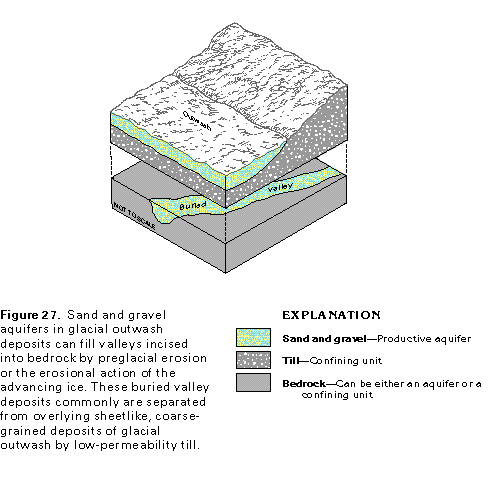
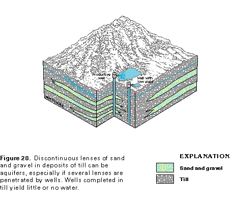
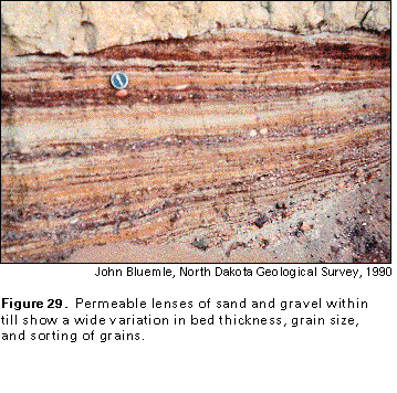
During the Pleistocene Epoch, massive ice sheets that were part of continental glaciers covered north-central and northeastern Montana, the eastern one-half of South Dakota, and most of North Dakota except for the southwestern corner of the State (fig. 25). Glacial deposits range in thickness from a feather edge near the western and southern limits of glaciation to more than 400 feet in some areas of eastern North Dakota and South Dakota (fig. 26). In Montana, the glacial deposits commonly are less than 100 feet thick. Most of the continental glacial deposits consist of till, which is a mixture of unsorted clay, silt, sand, gravel, and boulders that was deposited beneath or at the margins of the ice. Glacial meltwater, however, deposited well-sorted sand and gravel along stream valleys and in outwash plains; in places, these coarse-grained deposits are as much as 400 feet thick and are important aquifers. Although some of these sand and gravel aquifers extend to the land surface, most are buried, ancient stream channel deposits that formed in either valleys of meltwater streams or valleys incised into the bedrock (fig. 27). The buried valley deposits can be covered with confining units that consist of till or fine-grained glacial lake deposits, which can, in turn, be covered with glacial outwash deposits of sheetlike sand and gravel that compose productive aquifers. Several aquifers in buried valleys have been developed as sources of freshwater; the locations of other valleys are not well known, and many undiscovered buried valleys probably exist. Permeable lenses of sand and gravel within the till form aquifers that yield sufficient water for domestic use, especially where several lenses are penetrated by a well (fig. 28). Nearby wells that do not penetrate sand and gravel beds, however, yield little or no water. Lenses of sand and gravel in till beds differ as to thickness, sediment grain size, degree of sorting (fig. 29), and iron content and oxidization.
Unconsolidated-deposit aquifers that consist of sand and gravel deposited as alluvium along streams in the central part of Segment 8 (fig. 25) generally are thin, narrow bands. These aquifers in stream-valley alluvium locally yield sufficient water for some uses but generally are less productive than the other unconsolidated-deposit aquifers. Many of the aquifers along stream valleys are not shown in figure 25 because of the scale of the map.
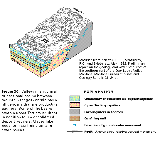
In western Montana and western and central Wyoming, unconsolidated-deposit aquifers are mostly alluvial deposits that partly fill broad valleys in mountainous areas (fig. 25). The basins that contain these deposits were formed by faulting or erosion or both. The alluvium was deposited primarily as coalescing alluvial fans by streams that flowed into the valleys from the surrounding mountains (fig. 30). In some valleys, the basin-fill alluvial deposits contain glacial outwash and other types of deposits that resulted from alpine glaciation; the extent of the glaciation is not known. Locally, sand and gravel beds of late Tertiary age compose aquifers beneath the Quaternary deposits that form most of the basin fill (fig. 30). The upper Tertiary aquifers can be distinguished only with difficulty from the younger unconsolidated-deposit aquifers in most basins. Clayey lake-bed deposits form confining units in some basins; such conditions are particularly common in valleys in Montana. The thickness of the unconsolidated-deposit aquifers is unknown in most basins because no wells totally penetrate the aquifers but is known to be as much as 900 feet in some basins. Basin-fill deposits typically are coarse grained near basin margins and finer grained toward basin centers.
The permeability of the unconsolidated-deposit aquifers is variable. Average yields of wells completed in these aquifers range from about 1 to 1,000 gallons per minute. Yields of wells completed in thick sequences of coarse sand and gravel, however, can exceed 3,500 gallons per minute. Depths of wells completed in glacial outwash deposits generally are less than 300 feet; wells completed in alluvium along stream valleys generally are less than 100 feet deep; and wells completed in basin-fill deposits are as deep as 900 feet.
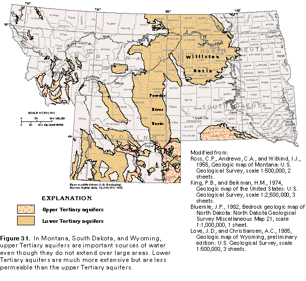
Upper Tertiary aquifers (fig. 31) are mostly beds of unconsolidated to semiconsolidated sand and gravel of Pliocene and Miocene age. Fine-grained deposits of clay and silt commonly are interbedded or mixed with the sand and gravel. Thin beds of basalt and volcanic ash are interbedded locally with the sediments that compose the upper Tertiary aquifers in Montana. In some places, especially in Montana, thin, discontinuous deposits of Quaternary age are included in the upper Tertiary aquifers in this report.
In southern South Dakota and southeastern Wyoming, upper Tertiary aquifers consist of broad, extensive sheets of alluvium that were deposited by a network of branching and rejoining streams. The source of the alluvium was the Middle Rocky Mountains to the west. Thick sequences of sand and gravel in the alluvium compose productive aquifers, especially in the Miocene Ogallala Formation and the Miocene and Oligocene Arikaree Formation. The upper Tertiary aquifers in this area are part of the High Plains aquifer system, which is as much as 1,000 feet thick in southeastern Wyoming.
Upper Tertiary aquifers in western Montana and central and western Wyoming are mostly in the same small structural and erosional basins that contain unconsolidated-deposit aquifers, whereas in central Wyoming, the aquifers are in the large Wind River, the Great Divide, and the Washakie structural basins. The upper Tertiary aquifers in these basins consist of sand and gravel that were deposited as overlapping and coalescing alluvial fans by streams that entered the basins from the surrounding mountains. In places, the alluvial fans have been partly eroded, and the upper Tertiary aquifers are exposed as shelflike terraces cut in or near the basin walls (fig. 30). The alluvial deposits in the terraces generally are extremely permeable and allow water to percolate rapidly downward through the deposits to the water table. Upper Tertiary aquifers generally are less than 2,000 feet thick but are as much as 6,000 feet thick in some basins.
The permeability of the upper Tertiary aquifers is variable and directly related to the grain size and sorting of the deposits that compose the aquifers. Where the aquifers consist primarily of sand and gravel, they are extremely permeable; permeability decreases as clay content increases. Generally, the upper Tertiary aquifers become more clayey and less permeable as depth increases. Yields of wells completed in these aquifers are reported to range from 5 to 800 gallons per minute, but yields of a few wells exceed 2,000 gallons per minute. In South Dakota, most wells yield 100 gallons per minute or less and yields rarely exceed 1,500 gallons per minute.
Because the upper Tertiary aquifers usually are at shallow depths, most wells completed in the aquifers are less than 600 feet deep. However, some well depths exceed 1,000 feet in southeastern Wyoming.
Lower Tertiary aquifers (fig. 31) consist mostly of semi- consolidated to consolidated sandstone beds of Oligocene to Paleocene age. The water-yielding sandstones are interbedded with shale, mudstone, siltstone, lignite, and coal and locally with beds of limestone, none of which are considered to be aquifers. Some coal beds yield water, particularly if the coal is fractured or has been partially burned and has formed clinker zones. Most of the lower Tertiary rocks were deposited in continental environments, but some of the shale and limestone beds were deposited in a marine environment and form confining units. The lower Tertiary aquifers contain freshwater over a larger area of Segment 8 than any other aquifers. Because of their wide extent, the lower Tertiary aquifers are an important source of supply even though they are not highly permeable.
Lower Tertiary aquifers in eastern Montana, western North Dakota and South Dakota, and northeastern Wyoming consist mostly of sandstone beds in the Fort Union Formation of Paleocene age. Lower Tertiary rocks in this area include those of the Fort Union coal region (shown in figure 54 in the Northern Great Plains aquifer system section of this report), which contains a major part of the Nation's reserves of coal. The lower Tertiary aquifers in this area are downwarped into the Williston and the Powder River Basins and consist of parts of the uppermost consolidated-rock formations in these basins. Lower Tertiary rocks generally are less than 1,000 feet thick in the Williston Basin, but not all these rocks yield water. The rocks that compose the lower Tertiary aquifers contain more shale in their eastern parts than elsewhere, and the transmissivity of the aquifers, therefore, decreases to the east.
In the western two-thirds of Wyoming and adjacent areas of Montana, the lower Tertiary aquifers usually are in structural basins that have been downwarped to great depths. The lower Tertiary aquifers in these basins are mostly in sandstone beds of the Eocene and locally Paleocene Wasatch Formation and the Paleocene Fort Union Formation. The total thickness of lower Tertiary rocks in some of these basins is as much as 10,000 feet; however, the cumulative thickness of the aquifers rarely exceeds 3,000 feet because not all the lower Tertiary rocks are permeable.
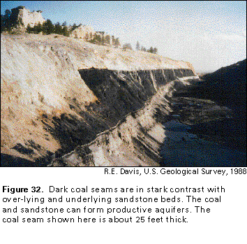
The permeability of the lower Tertiary aquifers is variable and is directly related to the amount of interconnected pore space in the sandstone beds that compose the aquifers. Most of the pore space consists of openings between individual sand grains, but some is secondary openings, such as bedding planes and joints. Thick coal seams, which are interbedded with sandstone (fig. 32) or with fine-grained sediments, also can have joints and bedding planes that store and transmit water. Where erosion has exposed coal beds at the land surface, wildfires or lightning have ignited some of the beds. The coal then burned until the oxygen supply in the beds was exhausted and, thus, formed clinker zones (fig. 33) that are extremely permeable and can extend a considerable distance into the buried parts of the coal beds. Where the clinker zones are saturated, they form productive aquifers from which springs issue. However, most known clinker zones are above the water table.
Yields of most wells completed in the lower Tertiary aquifers range from 1 to 50 gallons per minute in Montana, South Dakota, and Wyoming and from 1 to 100 gallons per minute in North Dakota. Maximum yields exceed 500 gallons per minute in South Dakota and 1,000 gallons per minute in Wyoming. These aquifers are deeply buried or overlain by fine-grained rocks in many places. Wells completed in the aquifers commonly are 300 to 900 feet deep and locally are 1,000 to 3,000 feet deep.
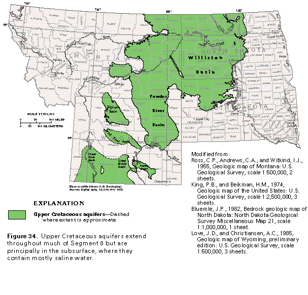
Upper Cretaceous aquifers extend over a wide area in the central parts of Segment 8 (fig. 34). These aquifers are widespread in the subsurface but contain freshwater only where they crop out and for a short distance downdip of where they are covered by younger rocks. Beds of consolidated sandstone compose most of the upper Cretaceous aquifers. The sandstone is interbedded with shale, siltstone, and occasional thin, lenticular beds of coal.
Upper Cretaceous aquifers crop out mostly around the edges of the Williston and the Powder River Basins but are exposed in smaller areas along the margins of the Green River, the Great Divide, the Hanna, the Wind River, and the Bighorn Basins. The aquifers are downwarped and faulted to depths of several thousand feet in these basins but contain mostly saline water in their deeper parts. The principal water-yielding formations are the Hell Creek Formation and the Fox Hills Sandstone. In western Wyoming, some water is obtained from the Lance Formation, which is equivalent to the Hell Creek, and from the deeper Mesaverde Formation. The Judith River Formation and the Eagle Sandstone in west-central Montana also are used as a source of supply; these formations are not sufficiently permeable to yield water in eastern Montana. Small volumes of water are obtained locally from wells completed in calcareous lenses of the chalky, shaly Niobrara Formation in North Dakota and South Dakota and from the Greenhorn Limestone and the Codell Sandstone Member of the Carlisle Shale in eastern South Dakota.
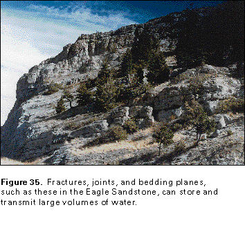
Most of the water in the sandstone aquifers is in pore spaces between individual grains of sand, but some of the aquifers contain fractures, bedding planes, and joints that provide large-scale openings (fig. 35) which store and transmit most of the water. Where sandstone beds are thin and interbedded with shale or other rocks that have minimal permeability, wells might need to be drilled deep enough to penetrate several sandstone beds in order to obtain an adequate supply of water.
The Pierre Shale, which is a major confining unit in eastern Montana and in most of North Dakota and South Dakota, is more than 3,000 feet thick in places. The Pierre Shale underlies the Fox Hills Sandstone and separates it from deeper aquifers. Locally, the Pierre Shale yields small volumes of water from thin sandstone beds or from highly weathered or fractured zones in the uppermost shale beds. The water usually is highly mineralized, however, and the Pierre Shale is not considered to be a principal aquifer even though it yields sufficient water to supply many domestic wells. The Pierre Shale subcrops over about one-third of eastern North Dakota and about two-thirds of eastern South Dakota.
The permeability of the upper Cretaceous aquifers is somewhat variable, but generally not as great as that of the aquifers in younger rocks. Wells completed in the Hell Creek Formation and the Fox Hills Sandstone have yields that range from 5 to 50 gallons per minute. Locally, these formations yield about 200 gallons per minute in Montana, 300 gallons per minute in North Dakota, and 1,000 gallons per minute in some of the structural basins in Wyoming. Yields of wells completed in the Judith River Formation and the Eagle Sandstone commonly range from 5 to 20 gallons per minute, but locally exceed 200 gallons per minute. Wells that obtain water from the upper Cretaceous aquifers generally are less than 800 feet deep but a few wells are as deep as 2,000 feet in Montana and 3,000 feet in Wyoming.
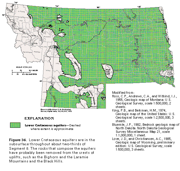
Lower Cretaceous aquifers extend over about two-thirds of Segment 8 (fig. 36) but are exposed at the land surface mostly as wide to narrow bands that completely or partly encircle basins or uplifted areas. Tectonic forces that acted on the Earth's crust warped formerly flat-lying rocks into several such structures. Subsequent erosion has exposed older rocks at the centers of the folds; progressively younger rocks surround the centers as concentric bands. The lower Cretaceous aquifers commonly contain highly mineralized water where they are deeply buried.
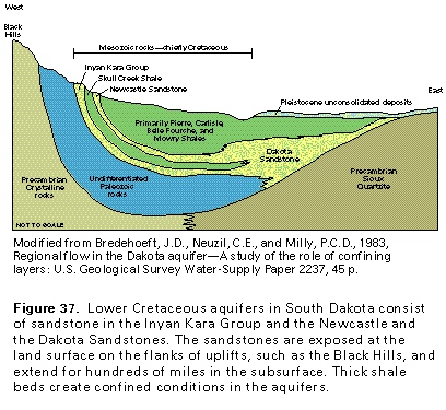
Formations of consolidated sandstone compose the lower Cretaceous aquifers. Perhaps one of the best known and earliest described artesian aquifers in the Nation is the Dakota aquifer (locally called the Inyan Kara aquifer), which is in Lower Cretaceous rocks that are exposed on the flanks of the Black Hills Uplift and extend more than 300 miles across South Dakota in the subsurface (fig. 37). The Newcastle Sandstone merges eastward in the subsurface with sandstones of the Inyan Kara Group to become the Dakota Sandstone. In Montana, North Dakota, and Wyoming, the Muddy Sandstone and equivalent water-yielding rocks overlie the Skull Creek Shale and are equivalent to the Newcastle Sandstone. Sandstones equivalent to the Inyan Kara Group in North Dakota and South Dakota are part of the Kootenai Formation in central and western Montana. The Cloverly Formation in Wyoming, which is equivalent to the Dakota Sandstone, is an important aquifer.
Because the sandstones of the Dakota aquifer receive some recharge at high altitudes and some by upward leakage from deeper aquifers, the water in the aquifer is under high artesian pressure. When development of the Dakota aquifer began in the late 19th century, many wells completed in the aquifer flowed at the land surface. The rate of flow of some wells was as much as 4,000 gallons per minute, and much water was wasted because these wells were allowed to flow continuously. Water levels in the aquifer declined 700 feet or more in some places.
Water in the Dakota aquifer moves hundreds of miles from recharge areas to places where the water discharges upward to shallower aquifers, surface-water bodies, or wells. Because the water is in contact with aquifer minerals for a long time, it commonly contains large concentrations of dissolved minerals. The aquifer contains water with dissolved-solids concentrations of greater than 10,000 milligrams per liter in about one-half of North Dakota and in a large part of northwestern South Dakota. Locally, in parts of the Williston Basin in extreme northeastern Montana, the aquifer is more than 5,500 feet below the land surface and contains brine.
Sandstone beds of Jurassic age locally form minor aquifers in Segment 8. For example, sandstone of the Jurassic Sundance Formation yields water in several counties in east-central South Dakota. In general, however, the Jurassic sandstones are thin, of limited extent, and little used for water supply in Segment 8. The local Jurassic aquifers are included in the lower Cretaceous aquifers in this report.
Porosity and permeability are variable in the lower Cretaceous aquifers. Yields of most wells completed in these aquifers range from about 5 to 60 gallons per minute, which is about the same as that reported for wells in the upper Cretaceous aquifers. Yields of some wells completed in the lower Cretaceous aquifers exceed 500 to 1,000 gallons per minute, however. Wells must be drilled to considerable depths in many places because the lower Cretaceous aquifers commonly are deeply buried. Some wells completed in these aquifers are 5,000 feet deep or more.
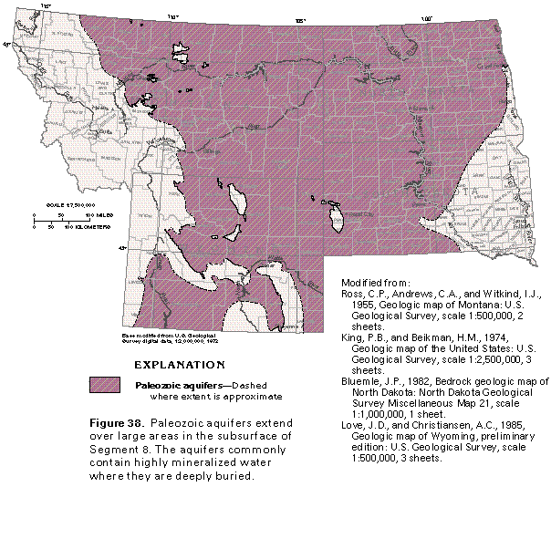
Paleozoic aquifers extend over about three-fourths of Segment 8 in the subsurface (fig. 38) but are exposed at the land surface only in small areas. Small areas in western Montana and western Wyoming are underlain by Paleozoic aquifers in outcrop and in the subsurface, but these areas are separated by faults from the main body of the aquifers. The Paleozoic aquifers consist mostly of limestone and dolomite, but some Paleozoic sandstones also yield water. Confining units that overlie and separate the aquifers consist of shale and siltstone with some beds of anhydrite and halite (rock salt). The Paleozoic aquifers can be separated into two groups-those in upper Paleozoic rocks and those in lower Paleozoic rocks-but they are mapped together in figure 38 because of the scale of the map.
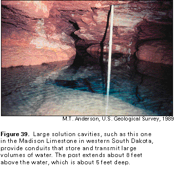
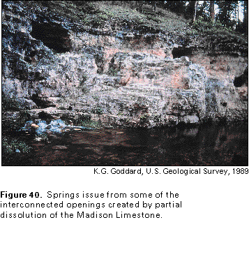
Although some water is obtained from wells completed in the Tensleep Sandstone and in sandstone beds of the Minnelusa Formation and equivalent rocks, which are of Pennsylvanian and Permian age, the most productive aquifer in upper Paleozoic rocks is the Madison Limestone of Devonian and Mississippian age. The Madison Limestone, or Group, was deposited in warm, shallow marine waters and originally contained much lime mud. Initially, the limestone had minimal permeability until it was altered by the processes of dolomitization, dedolomitization, and partial dissolution, all of which increased the permeability. In some places, large solution cavities, through which large volumes of water can move rapidly, have developed in the limestone (fig. 39). Wells that penetrate such solution cavities can yield extremely large volumes of water, especially where several cavities are interconnected. Springs commonly issue from solution openings in the Madison Limestone (fig. 40); the flow of one of these springs in Montana is reported to be 300 cubic feet per second, or about 194 million gallons per day.
Aquifers in lower Paleozoic rocks consist mostly of the Bighorn and the Whitewood Dolomites and limestone and dolomite beds in the Red River Formation, which are all of Ordovician age. Locally, limestone and dolomite of the Darby Formation (Devonian and Mississippian), sandstones of the Winnipeg Formation (Ordovician), the Deadwood Formation (Cambrian and Ordovician) and the Flathead Sandstone (Cambrian) yield small volumes of water. Confining units of shale, shaly carbonate rocks, anhydrite beds, and halite of Devonian, Silurian, and Cambrian age locally separate the aquifers in lower Paleozoic rocks from the Madison Limestone. Except near the mountains, the aquifers in lower Paleozoic rocks are deeply buried and, therefore, are not a major source of water.
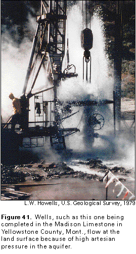
The Paleozoic aquifers receive recharge where they are exposed at the land surface on the flanks or crests of anticlines or by downward leakage from shallower aquifers in places where the shallower aquifers have higher hydraulic heads. From aquifer outcrop areas, ground water moves down the dip of the aquifers into major structural basins, such as the Powder River, the Wind River, and the Bighorn in Wyoming and the Williston in Montana, North Dakota, and South Dakota. The water eventually discharges by upward leakage to shallower aquifers or moves to the land surface where the aquifers are exposed on the borders of the basins. Where they are buried to great depths, the Madison Limestone and older, permeable Paleozoic rocks contain oil, gas, and brine in places. Fresh ground water that moves around the margins of bodies of brine can become highly mineralized as it mixes with the dense brine. Water that discharges from the Paleozoic aquifers in northeastern North Dakota and the Canadian Province of Manitoba contains large concentrations of dissolved solids as a result of this type of mixing. Recharge areas of the Paleozoic aquifers generally are at high altitudes, and, in the subsurface, the aquifers are overlain by confining units in most places. As a result, water in these aquifers is under high artesian pressure, and wells completed in the aquifers commonly flow at the land surface (fig. 41). The flow from the well shown in figure 41 is obtained from the Madison Limestone. The well, which is located just east of Billings, Mont., is about 5,000 feet deep and artesian pressure is sufficient to push water about 1,000 feet above land surface.