GEOTHERMAL WATER
GEOTHERMAL WATER
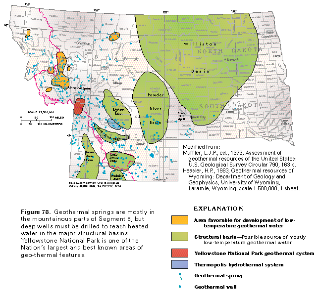
Geothermal water, or ground water which has a temperature appreciably higher than that of the local average annual air temperature, is in all four States of Segment 8 (fig. 78). Although geothermal water is not extensively developed as a source of energy in the segment, the water is potentially useful for space heating, food processing, or other purposes. Where geothermal water is sufficiently hot, it can be used for space heating by pumping the water directly into pipes and radiators; heat pumps can be used to extract the heat from lower temperature water.
Some geothermal water contains large concentrations of dissolved minerals, such as sodium, calcium, sulfate, chloride, or iron. These ions have been dissolved from the minerals in the rocks that compose the geothermal reservoirs and vary as the mineral composition of the rocks varies. Concentrations of some constituents usually exceed those in the standards recommended for drinking water by the U.S. Environmental Protection Agency; thus, geothermal water that is withdrawn and used can become a disposal problem. In South Dakota, reinjection of geothermal water is required. In the area east of the Continental Divide in Segment 8, much of the geothermal water contains large concentrations of dissolved solids.
Large structural basins in parts of Montana, North Dakota, South Dakota, and Wyoming (fig. 78) are possible sources of low-temperature geothermal water, or water which has a temperature of less than 194 degrees Fahrenheit. Low-temperature geothermal water is reported from some deep wells in the Williston Basin and in shallow wells (less than 3,000 feet deep) in western North Dakota. Geothermal water discharges from numerous springs located mostly in the mountainous areas of Montana and Wyoming (fig. 78). The springs are connected by faults to deeply buried reservoirs that contain geothermal water, which moves upward along the fault zones to discharge at the land surface. A few areas in Montana and Wyoming are known to have low-temperature geothermal water of sufficient lateral extent to be favorable for development.
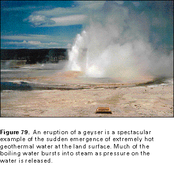
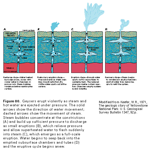
The concentration and variety of surface geothermal features in Yellowstone National Park (fig. 78) and the large size of some of these features make the Park one of the world's most impressive showplaces for naturally occurring hot water. More than 10,000 individual thermal features, including geysers, hot springs, mud volcanos, and fumaroles (steam vents), have been identified. Geysers are perhaps the best known and certainly the most spectacular features (fig. 79). They are a type of hot spring that periodically emits sudden, violent eruptions of steam and hot water. The periodic eruptions are thought to result from conditions like those shown in figure 80. A vertical tube extends downward from the vent of the geyser to saturated layers of hot rock. Chambers or side channels branch laterally off the tube and form reservoirs where cooler water is stored in porous rock. Rising steam bubbles at first condense in the cooler water (fig. 80A), but soon concentrate at narrow parts of the vertical tube. The expanding steam builds up pressure, and small spurts of steam and hot water can discharge at the land surface as preliminary eruptions (fig. 80B). At the same time, heat and pressure continue to increase in the water and steam column in the subsurface. Eventually, the preliminary eruptions remove enough water to create a sudden relief of pressure in the vertical tube and side chambers; water in the tube and chambers suddenly flashes into steam, and a full-scale eruption takes place (fig. 80C). The explosive release of pressure can cause a column of steam and hot water to rise 200 feet or more into the air. Occasionally, the eruptive force is great enough to break and eject some of the rocks through which the steam and hot water rise. After pressure is relieved by the eruption of the geyser, water begins to seep back into the vertical tube and side chambers (fig. 80D) and the eruptive cycle begins again. The period between eruptions depends on several factors, including the volume of steam and water that is ejected and how rapidly ground water refills the tubes and chambers.
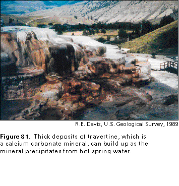
Much geothermal water discharges as hot springs that flow steadily instead of erupting at intervals. The hot spring water commonly contains large concentrations of silica (if the water has moved through such rocks as rhyolite, which is rich in silica) or calcium carbonate (if the water has moved through limestone or other calcite-rich rocks). The minerals precipitate as the spring water discharges at land surface. Thick deposits of travertine (a calcium carbonate mineral also called calcareous sinter), such as those shown in figure 81, or siliceous sinter (a silica mineral) can form large terracelike features near the spring vents. Iron oxide, manganese oxide, or coatings of sulfur, sulfide minerals, or algae can impart bright colors to the spring deposits.
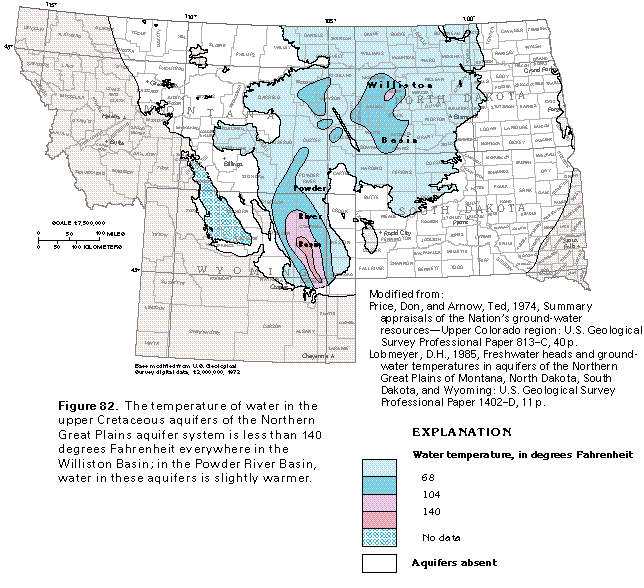
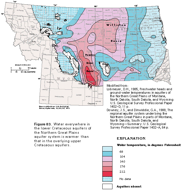
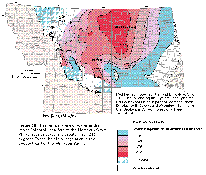
The temperature of ground water increases as the depth of burial of aquifers increases because of the geothermal gradient, which is a natural increase in the temperature of the Earth as depth increases. The geothermal gradient in the Williston Basin, for example, is about 2 degrees Fahrenheit per 100 feet of depth; thus, the temperature of the water at the bottom of a well that is 1,000 feet deep would be about 20 degrees Fahrenheit warmer than the average annual air temperature at the land surface. Maps of the temperature of water in the four deepest aquifers of the Northern Great Plains aquifer system (figs. 82-85) demonstrate that the water temperature increases as the depth of burial of the aquifers increases.
Water temperatures in the upper Cretaceous aquifers are 140 degrees Fahrenheit or less in the Williston Basin (fig. 82). In the Powder River Basin where the aquifers are more deeply buried, they contain water with temperatures of greater than 140 degrees Fahrenheit. Most of the water temperatures used to construct the map were measured in wells completed in the Fox Hills Sandstone.
Temperatures of water from the underlying lower Cretaceous aquifers are greater than 212 degrees Fahrenheit in the Powder River Basin (fig. 83) and greater than 176 degrees Fahrenheit in part of the Williston Basin. Most of the temperatures used to construct the map were measured in wells completed in the Dakota Sandstone and are higher everywhere than those in the upper Cretaceous aquifers.
Temperatures of water in the upper Paleozoic aquifers (fig. 84) are greater than 212 degrees Fahrenheit in most of the Powder River and the Bighorn Basins and in small areas of the Williston Basin. The temperatures used to construct the figure were measured in wells completed in the Pennsylvanian Tensleep Sandstone in the Bighorn Basin and in the Madison Limestone or equivalent rocks of Mississippian age elsewhere. The upper Paleozoic aquifers are considerably deeper, especially in the structural basins, than the overlying lower Cretaceous aquifers.
Water in the lower Paleozoic aquifers (fig. 85) in the Williston Basin shows a temperature-distribution pattern similar to that of the upper Paleozoic aquifers; that is, temperatures are lowest near the margins of the basin and greatest near the center of the basin. Temperatures in water from the lower Paleozoic aquifers are higher almost everywhere than those of water from shallower aquifers. Water temperatures in the lower Paleozoic aquifers (mostly Cambrian sandstones and Ordovician limestones) are greater than 176 degrees Fahrenheit throughout large parts of the Williston Basin and are greater than 212 degrees Fahrenheit in most of the deep parts of the basin.
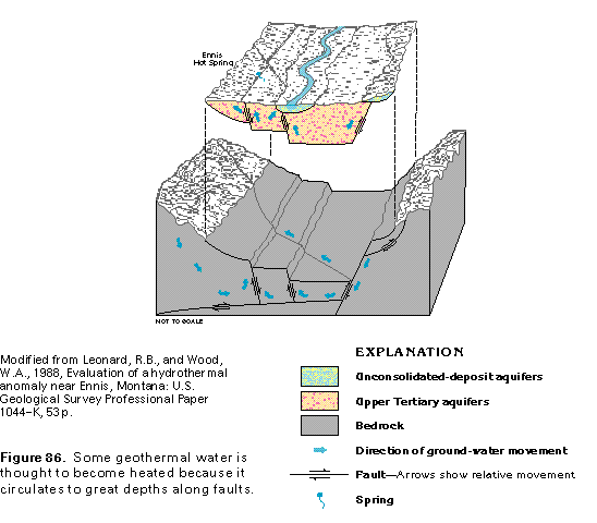
One theory used to explain how geothermal water becomes heated in areas that are underlain by complex geologic structures is shown in figure 86. Precipitation that falls in highland areas recharges the aquifer system. Some of the water moves downward along faults and fracture zones to great depths. As the water descends, it becomes heated because of the geothermal gradient. At some depth, the heated water becomes lighter than the overlying water and then moves upward along faults to discharge as springflow. Some of the upward-moving water can be intercepted by wells. The water that discharges from the Ennis Hot Spring in Madison County, Mont., and the Thermopolis hydrothermal system in Hot Springs County, Wyo. (fig. 78), is thought to have been heated by deep circulation along fault systems.
Deeply circulating ground water also can become heated by cooling magma (molten igneous rock) at great depths in the crust of the Earth. The water warms as it descends, possibly along fault zones that overlie the magma chamber, until it absorbs enough heat to become lighter than overlying water. The warm water then rises to the surface. The mechanism for the circulation of the water is the same, regardless of whether the water becomes heated by the geothermal gradient or by the buried, cooling magma.