GROUND WATER ATLAS of the UNITED STATES
Iowa, Michigan, Minnesota, Wisconsin
HA 730-J
Jacobsville and crystalline-rock aquifers
There are two different files for each illustration
- A 90 ppi JPEG file, suitable for screen viewing is accessed
through the thumbnail image.
- A tiff file is accessed through the "tiff file"
link. All files are Adobe Photoshop. These files have been compressed
with GNU's gzip utility. If your web browser defaults to a screen
display of the file, turn on the "Load to local disk"
option before downloading. Download and process these tiff files
as ascii, not binary.
Jacobsville Aquifer
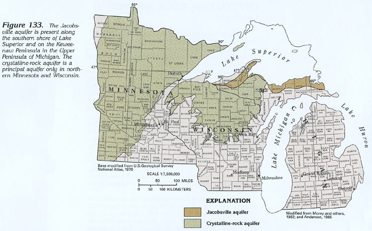
Figure 133 Map showing location of the Jacobsville and crystalline-rock
aquifers (334K)
 downloadable tiff file J133.tif.gz (2.7MB
compressed)
downloadable tiff file J133.tif.gz (2.7MB
compressed)
Figure 134 Correlation chart providing information
about the Jacobsville and crystalline-rock aquifers (99K)
 downloadable tiff file J134.tif.gz (646K
compressed)
downloadable tiff file J134.tif.gz (646K
compressed)
Figure 135 Generalized section showing placement
of Jacobsville Sandstone (119K)
 downloadable tiff file J135.tif.gz (820K
compressed)
downloadable tiff file J135.tif.gz (820K
compressed)
Figure 136 Map showing location of Jacobsville
Sandstone in upper Michigan (183K)
 downloadable tiff file J136.tif.gz (1.6MB
compressed)
downloadable tiff file J136.tif.gz (1.6MB
compressed)
Figure 137 Map showing thickness of the Jacobsville
Sandstone (117K)
 downloadable tiff file J137.tif.gz (995K
compressed)
downloadable tiff file J137.tif.gz (995K
compressed)
Table 11 Table showing chemical analysis of water
from the Jacobsville aquifer (64K)
 downloadable tiff file
Jtab11.tif.gz (234K compressed)
downloadable tiff file
Jtab11.tif.gz (234K compressed)
Figure 138 Pie chart showing use of fresh ground-water
withdrawals from the Jacobsville aquifer during 1985 (125K)
 downloadable tiff file J138.tif.gz (1MB
compressed)
downloadable tiff file J138.tif.gz (1MB
compressed)
 downloadable tiff file J133.tif.gz (2.7MB
compressed)
downloadable tiff file J133.tif.gz (2.7MB
compressed)  downloadable tiff file J134.tif.gz (646K
compressed)
downloadable tiff file J134.tif.gz (646K
compressed) 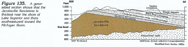 downloadable tiff file J135.tif.gz (820K
compressed)
downloadable tiff file J135.tif.gz (820K
compressed) 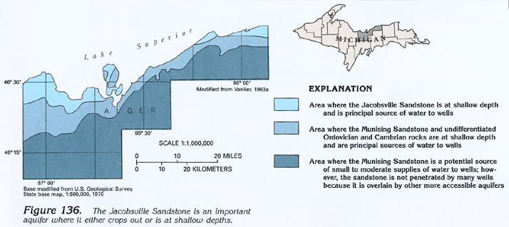 downloadable tiff file J136.tif.gz (1.6MB
compressed)
downloadable tiff file J136.tif.gz (1.6MB
compressed)  downloadable tiff file J137.tif.gz (995K
compressed)
downloadable tiff file J137.tif.gz (995K
compressed)  downloadable tiff file
Jtab11.tif.gz (234K compressed)
downloadable tiff file
Jtab11.tif.gz (234K compressed)  downloadable tiff file J138.tif.gz (1MB
compressed)
downloadable tiff file J138.tif.gz (1MB
compressed)