GROUND WATER ATLAS of the UNITED STATES
Iowa, Michigan, Minnesota, Wisconsin
HA 730-J
Jacobsville and crystalline-rock aquifers
There are two different files for each illustration
- A 90 ppi JPEG file, suitable for screen viewing is accessed
through the thumbnail image.
- A tiff file is accessed through the "tiff file"
link. All files are Adobe Photoshop. These files have been compressed
with GNU's gzip utility. If your web browser defaults to a screen
display of the file, turn on the "Load to local disk"
option before downloading. Download and process these tiff files
as ascii, not binary.
Crystalline Rock Aquifer
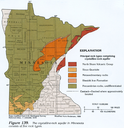
Figure 139 Map showing location of the principal rock types comprising
the crystalline-rock aquifer in Minnesota (271K)
 downloadable tiff file J139.tif.gz (2.3MB
compressed)
downloadable tiff file J139.tif.gz (2.3MB
compressed)
Table 12 Table showing water-yielding characteristics
of the crystalline-rock aquifer (154K)
 downloadable tiff file
Jtab12.tif.gz (1.3MB compressed)
downloadable tiff file
Jtab12.tif.gz (1.3MB compressed)
Figure 140 Map showing location of the crystalline-rock
aquifer in Wisconsin and upper Michigan (310K)
 downloadable tiff file J140.tif.gz (2.7MB
compressed)
downloadable tiff file J140.tif.gz (2.7MB
compressed)
Table 13 Table showing dissolved-solids concentrations
in water from the rock types comprising the crystalline-rock aquifer
in Minnesota (98K)
 downloadable tiff file
Jtab13.tif.gz (348K compressed)
downloadable tiff file
Jtab13.tif.gz (348K compressed)
Figure 141 Map showing dissolved-solids concentrations
of water in the crystalline-rock aquifer in Minnesota (268K)
 downloadable tiff file J141.tif.gz (2.3MB
compressed)
downloadable tiff file J141.tif.gz (2.3MB
compressed)
Figure 142 Pie chart showing freshwater withdrawals
from the crystalline-rock aquifer in Minnesota during 1985 (135K)
 downloadable tiff file J142.tif.gz (1.1MB
compressed)
downloadable tiff file J142.tif.gz (1.1MB
compressed)
 downloadable tiff file J139.tif.gz (2.3MB
compressed)
downloadable tiff file J139.tif.gz (2.3MB
compressed) 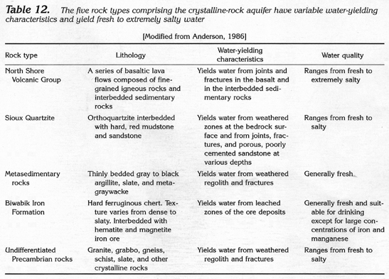 downloadable tiff file
Jtab12.tif.gz (1.3MB compressed)
downloadable tiff file
Jtab12.tif.gz (1.3MB compressed) 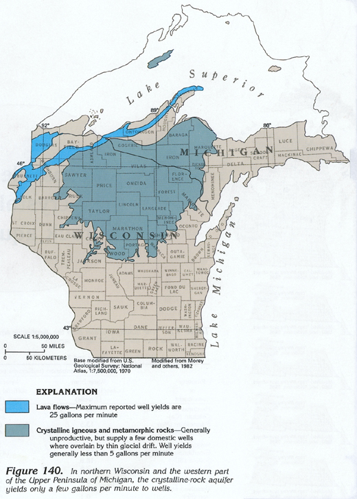 downloadable tiff file J140.tif.gz (2.7MB
compressed)
downloadable tiff file J140.tif.gz (2.7MB
compressed) 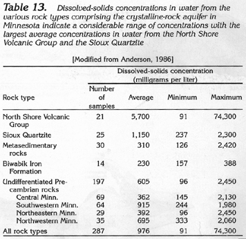 downloadable tiff file
Jtab13.tif.gz (348K compressed)
downloadable tiff file
Jtab13.tif.gz (348K compressed)  downloadable tiff file J141.tif.gz (2.3MB
compressed)
downloadable tiff file J141.tif.gz (2.3MB
compressed) 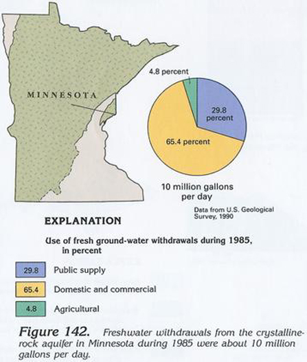 downloadable tiff file J142.tif.gz (1.1MB
compressed)
downloadable tiff file J142.tif.gz (1.1MB
compressed)