GROUND WATER ATLAS of the UNITED STATES
Iowa, Michigan, Minnesota, Wisconsin
HA 730-J
Mississippian aquifer
There are two different files for each illustration
- A 90 ppi JPEG file, suitable for screen viewing is accessed
through the thumbnail image.
- A tiff file is accessed through the "tiff file"
link. All files are Adobe Photoshop. These files have been compressed
with GNU's gzip utility. If your web browser defaults to a screen
display of the file, turn on the "Load to local disk"
option before downloading. Download and process these tiff files
as ascii, not binary.
Hydrogeologic Units
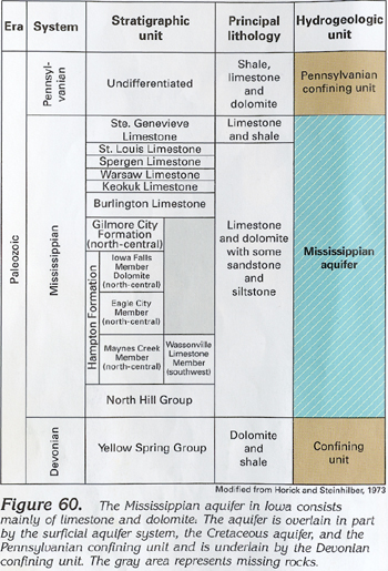
Figure 60 Correlation chart describing characteristics of the
Mississippian aquifer in Iowa (192K)
 downloadable tiff file J060.tif.gz (1.6MB
compressed)
downloadable tiff file J060.tif.gz (1.6MB
compressed)
Figure 61 Map showing thickness of the Mississippian
aquifer (539K)
 downloadable tiff file J061.tif.gz (11.2MB
compressed)
downloadable tiff file J061.tif.gz (11.2MB
compressed)
Figure 62 Correlation chart describing characteristics
of the Mississippian aquifer in Michigan (183K)
 downloadable tiff file J062.tif.gz (1.6MB
compressed)
downloadable tiff file J062.tif.gz (1.6MB
compressed)
Figure 63 Map showing altitude of the base of the
Mississippian aquifer in Michigan (161K)
 downloadable tiff file J063.tif.gz (3.0MB
compressed)
downloadable tiff file J063.tif.gz (3.0MB
compressed)
 downloadable tiff file J060.tif.gz (1.6MB
compressed)
downloadable tiff file J060.tif.gz (1.6MB
compressed) 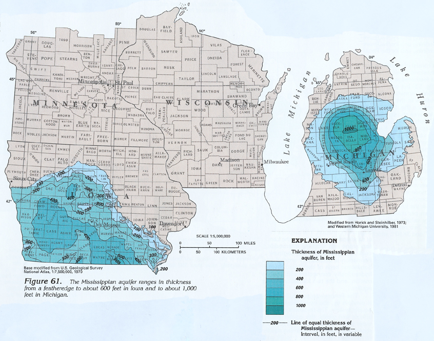 downloadable tiff file J061.tif.gz (11.2MB
compressed)
downloadable tiff file J061.tif.gz (11.2MB
compressed) 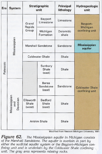 downloadable tiff file J062.tif.gz (1.6MB
compressed)
downloadable tiff file J062.tif.gz (1.6MB
compressed) 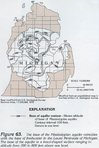 downloadable tiff file J063.tif.gz (3.0MB
compressed)
downloadable tiff file J063.tif.gz (3.0MB
compressed)