GROUND WATER ATLAS of the UNITED STATES
Iowa, Michigan, Minnesota, Wisconsin
HA 730-J
Pennsylvanian aquifer
There are two different files for each illustration
- A 90 ppi JPEG file, suitable for screen viewing is accessed
through the thumbnail image.
- A tiff file is accessed through the "tiff file"
link. All files are Adobe Photoshop. These files have been compressed
with GNU's gzip utility. If your web browser defaults to a screen
display of the file, turn on the "Load to local disk"
option before downloading. Download and process these tiff files
as ascii, not binary.
Hydrogeology
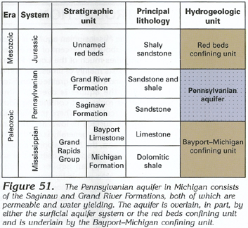
Figure 51 Correlation chart showing Pennsylvanian aquifer characteristics
(126K)
 downloadable tiff file J051.tif.gz (887K
compressed)
downloadable tiff file J051.tif.gz (887K
compressed)
Figure 52 Map showing thickness of the Jurassic
red beds (175K)
 downloadable tiff file J052.tif.gz (1.6MB
compressed)
downloadable tiff file J052.tif.gz (1.6MB
compressed)
Figure 53 Map showing thickness of the Pennsylvanian
aquifer (193K)
 downloadable tiff file J053.tif.gz (1.8MB
compressed)
downloadable tiff file J053.tif.gz (1.8MB
compressed)
Figure 54 Map showing water movement in the Pennsylvanian
aquifer (178K)
 downloadable tiff file J054.tif.gz (1.5MB
compressed)
downloadable tiff file J054.tif.gz (1.5MB
compressed)
Figure 55 Map showing potential yield of water
to wells in a three county area (215K)
 downloadable tiff file J055.tif.gz (2.1MB
compressed)
downloadable tiff file J055.tif.gz (2.1MB
compressed)
 downloadable tiff file J051.tif.gz (887K
compressed)
downloadable tiff file J051.tif.gz (887K
compressed) 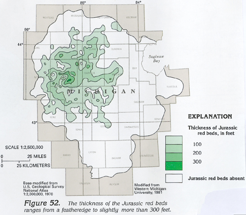 downloadable tiff file J052.tif.gz (1.6MB
compressed)
downloadable tiff file J052.tif.gz (1.6MB
compressed) 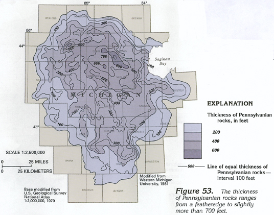 downloadable tiff file J053.tif.gz (1.8MB
compressed)
downloadable tiff file J053.tif.gz (1.8MB
compressed) 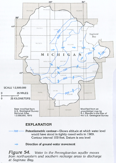 downloadable tiff file J054.tif.gz (1.5MB
compressed)
downloadable tiff file J054.tif.gz (1.5MB
compressed) 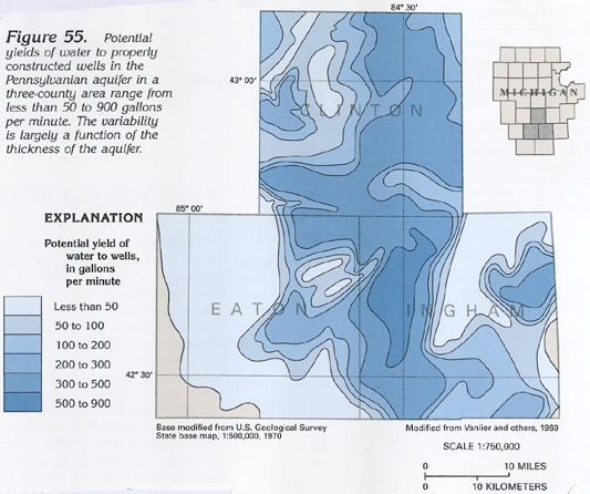 downloadable tiff file J055.tif.gz (2.1MB
compressed)
downloadable tiff file J055.tif.gz (2.1MB
compressed)