GROUND WATER ATLAS of the UNITED STATES
Iowa, Michigan, Minnesota, Wisconsin
HA 730-J
Silurian-Devonian aquifer
There are two different files for each illustration
- A 90 ppi JPEG file, suitable for screen viewing is accessed
through the thumbnail image.
- A tiff file is accessed through the "tiff file"
link. All files are Adobe Photoshop. These files have been compressed
with GNU's gzip utility. If your web browser defaults to a screen
display of the file, turn on the "Load to local disk"
option before downloading. Download and process these tiff files
as ascii, not binary.
Potential Well Yields
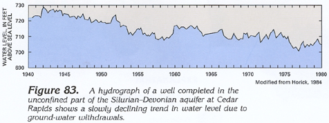
Figure 83 Hydrograph of well completed in the unconfined part
of the Silurian-Devonian aquifer at Cedar Rapids (83K)
 downloadable tiff file J083.tif.gz (626K
compressed)
downloadable tiff file J083.tif.gz (626K
compressed)
Figure 84 Hydrograph of well completed in the confined
part of the Silurian-Devonian aquifer at Dayton (128K)
 downloadable tiff file J084.tif.gz (1.2MB
compressed)
downloadable tiff file J084.tif.gz (1.2MB
compressed)
Figure 85 Map showing probable yield of water to
wells in the Silurian-Devonian aquifer in Wisconsin (178K)
 downloadable tiff file J085.tif.gz (1.6MB
compressed)
downloadable tiff file J085.tif.gz (1.6MB
compressed)
 downloadable tiff file J083.tif.gz (626K
compressed)
downloadable tiff file J083.tif.gz (626K
compressed) 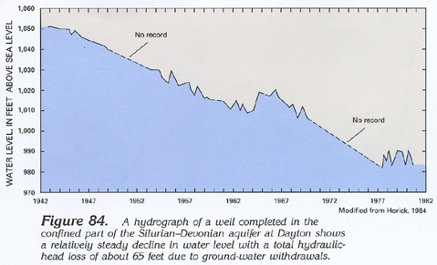 downloadable tiff file J084.tif.gz (1.2MB
compressed)
downloadable tiff file J084.tif.gz (1.2MB
compressed) 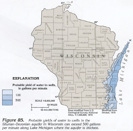 downloadable tiff file J085.tif.gz (1.6MB
compressed)
downloadable tiff file J085.tif.gz (1.6MB
compressed)