GROUND WATER ATLAS of the UNITED STATES
Iowa, Michigan, Minnesota, Wisconsin
HA 730-J
Regional summary
There are two different files for each illustration
- A 90 ppi JPEG file, suitable for screen viewing is accessed
through the thumbnail image.
- A tiff file is accessed through the "tiff file"
link. All files are Adobe Photoshop. These files have been compressed
with GNU's gzip utility. If your web browser defaults to a screen
display of the file, turn on the "Load to local disk"
option before downloading. Download and process these tiff files
as ascii, not binary.
Vertical Sequence of Aquifers
Figure 14 Map showing the location of the Cretaceous
and Pennsylvanian aquifers (220K)
 downloadable
tiff file J014.tif.gz (2.7MB
compressed)
downloadable
tiff file J014.tif.gz (2.7MB
compressed)
Figure 15 Map showing the location of the Mississippian
aquifer (220K)
 downloadable
tiff file J015.tif.gz (2.7MB
compressed)
downloadable
tiff file J015.tif.gz (2.7MB
compressed)
Figure 16 Map showing the location of the Silurian-Devonian
aquifer (220K)
 downloadable
tiff file J016.tif.gz (2.7MB
compressed)
downloadable
tiff file J016.tif.gz (2.7MB
compressed)
Figure 17 Map showing the location of the
upper carbonate aquifer (220K)
 downloadable
tiff file J017.tif.gz (2.7MB
compressed)
downloadable
tiff file J017.tif.gz (2.7MB
compressed)
Figure 18 Map showing the location of the Cambrian-Ordovician
aquifer system, and the Jacobsville and crystalline-rock aquifers
(220K)
 downloadable
tiff file J018.tif.gz (2.7MB
compressed)
downloadable
tiff file J018.tif.gz (2.7MB
compressed)
 downloadable
tiff file J014.tif.gz (2.7MB
compressed)
downloadable
tiff file J014.tif.gz (2.7MB
compressed) 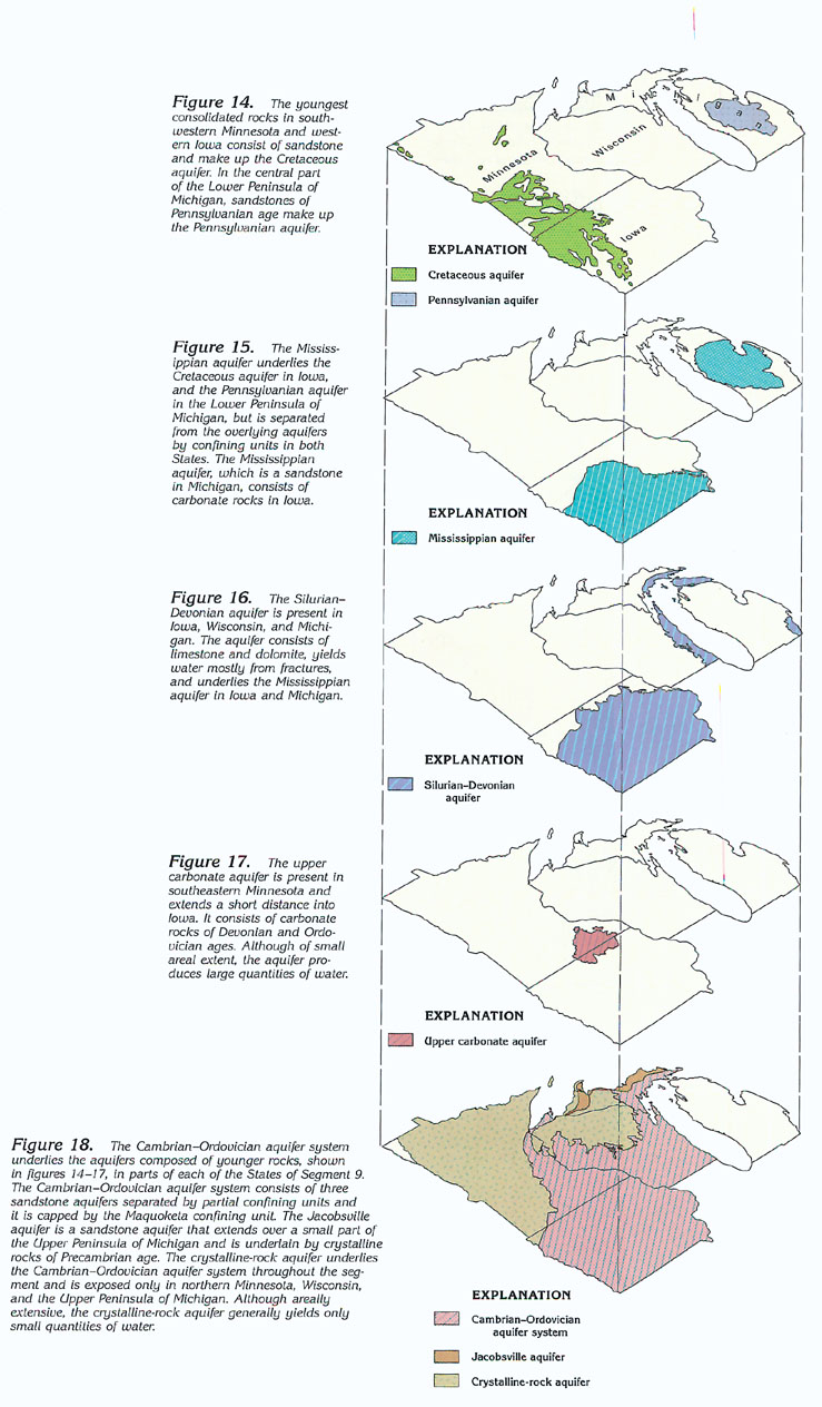 downloadable
tiff file J015.tif.gz (2.7MB
compressed)
downloadable
tiff file J015.tif.gz (2.7MB
compressed)  downloadable
tiff file J016.tif.gz (2.7MB
compressed)
downloadable
tiff file J016.tif.gz (2.7MB
compressed)  downloadable
tiff file J017.tif.gz (2.7MB
compressed)
downloadable
tiff file J017.tif.gz (2.7MB
compressed)  downloadable
tiff file J018.tif.gz (2.7MB
compressed)
downloadable
tiff file J018.tif.gz (2.7MB
compressed)