GROUND WATER ATLAS of the UNITED STATES
Iowa, Michigan, Minnesota, Wisconsin
HA 730-J
Regional summary
There are two different files for each illustration
- A 90 ppi JPEG file, suitable for screen viewing is accessed
through the thumbnail image
- A tiff file is accessed through the "tiff file"
link. All files are Adobe Photoshop. These files have been compressed
with GNU's gzip utility. If your web browser defaults to a screen
display of the file, turn on the "Load to local disk"
option before downloading. Download and process these tiff files
as ascii, not binary.
Fresh Ground-water Withdrawals
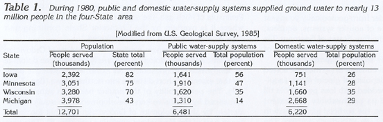
Table 1 Table showing ground-water as a source to public and
domestic water-supply systems (89K)
 downloadable
tiff file Jtab01.tif.gz
(640K compressed)
downloadable
tiff file Jtab01.tif.gz
(640K compressed)
Figure 22 Map showing fresh ground-water withdrawals
by county (323K)
 downloadable tiff file J022.tif.gz (2.9MB
compressed)
downloadable tiff file J022.tif.gz (2.9MB
compressed)
Figure 23 Graph showing yearly ground-water
withdrawals from the Cambrian-Ordovician aquifer system from 1880
to 1980 (125K)
 downloadable tiff file J023.tif.gz (1.1MB
compressed)
downloadable tiff file J023.tif.gz (1.1MB
compressed)
Figure 24 Graph showing that ground-water
withdrawals increased over time (84K)
 downloadable tiff file J024.tif.gz (697K
compressed)
downloadable tiff file J024.tif.gz (697K
compressed)
Figure 25 Diagram showing the amount of
water withdrawn from each aquifer during1985 (230K)
 downloadable tiff file J025.tif.gz (1.9MB
compressed)
downloadable tiff file J025.tif.gz (1.9MB
compressed)
Return to Regional summary text
Return to HA 730-J table of contents
Return to Ground Water Atlas home page
 downloadable
tiff file Jtab01.tif.gz
(640K compressed)
downloadable
tiff file Jtab01.tif.gz
(640K compressed)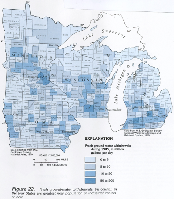 downloadable tiff file J022.tif.gz (2.9MB
compressed)
downloadable tiff file J022.tif.gz (2.9MB
compressed) 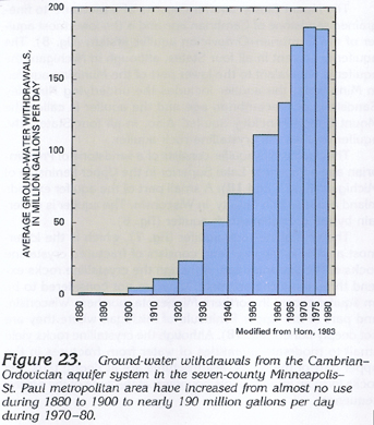 downloadable tiff file J023.tif.gz (1.1MB
compressed)
downloadable tiff file J023.tif.gz (1.1MB
compressed) 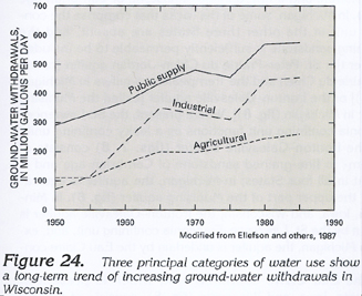 downloadable tiff file J024.tif.gz (697K
compressed)
downloadable tiff file J024.tif.gz (697K
compressed) 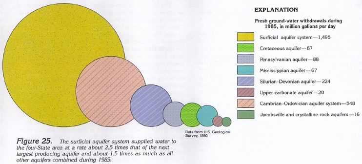 downloadable tiff file J025.tif.gz (1.9MB
compressed)
downloadable tiff file J025.tif.gz (1.9MB
compressed)