INTRODUCTION
The Cretaceous aquifer is used principally in northwestern Iowa and southwestern Minnesota (fig. 42) where it generally is the only source of ground water; however, it extends northward along the western Minnesota border as outliers and southward into southern and central Iowa (fig. 42). The aquifer consists of thick to thin, discontinuous sandstone beds overlain in places by limestone and shale beds that confine the aquifer. In other places, the aquifer is directly overlain by glacial deposits. In its principal area of use, the Cretaceous aquifer ranges from about 90 to 170 feet in thickness. Although the aquifer contains gypsum, which, when dissolved, markedly increases sulfate concentrations in the ground water, the aquifer is extensively pumped to supply domestic, small-community, and agricultural needs.
HYDROGEOLOGY
The Cretaceous aquifer is part of a sequence of sandstone, limestone,
and shale deposited during the Cretaceous Period by five major
transgressive-regressive marine cycles that inundated Minnesota,
Iowa, and western Wisconsin from the west. These rocks were deposited
on an irregular erosional surface that had a maximum relief of
about 1,400 feet. They were deposited primarily as fluvioldeltaic
deposits on crystalline and sedimentary rocks of Precambrian and
Paleozoic ages. A pre-Cretaceous regolith, which developed on
the underlying rocks, ranges in thickness from a feather edge
to 200 feet.
The surface of the Cretaceous sequence was deeply eroded prior to glaciation, and the Cretaceous rocks have been removed completely in some areas. Similarly, these rocks are thin or missing over highs on the underlying unconformity, such as the Sioux Quartzite Ridge and the Transcontinental Arch (fig. 42) of southwestern Minnesota. Cretaceous rocks are present primarily in the western parts of Minnesota and Iowa and as minor outliers in other parts of those States (fig. 42). The area where Cretaceous rocks yield sufficient water to wells for water supplies is in southwestern Minnesota and northwestern Iowa as shown in figure 42.
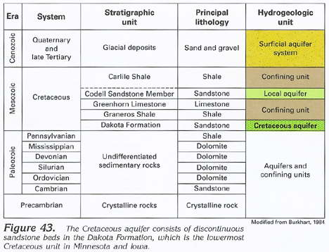
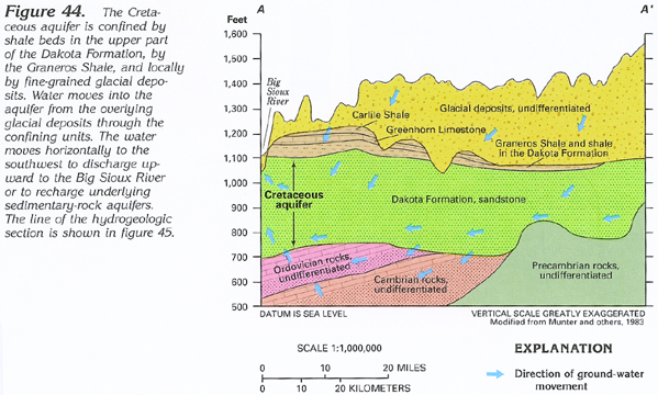
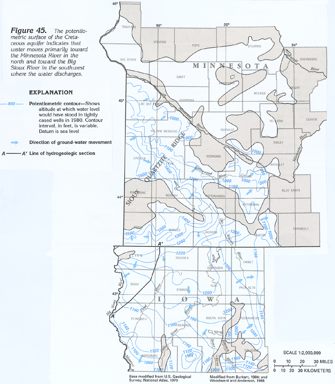
The Cretaceous aquifer consists of discontinuous sandstone beds in the Dakota Formation. Although some water is obtained locally from the Codell Sandstone Member of the Carlile Shale (fig. 43), this unit is not considered to be part of the Cretaceous aquifer. Water in the Dakota Formation is confined by the overlying Graneros Shale and locally by fine-grained glacial deposits that overlie the eroded surface of the Cretaceous rocks (figs. 43, 44). The potentiometric surface of water in the Cretaceous aquifer is above the top of the aquifer in most places. The vertical hydraulic gradient in the overlying glacial deposits, however, is downward, and recharge to the Cretaceous aquifer is from the surficial aquifer system, mostly through the confining beds (fig. 44). Locally, the Cretaceous aquifer also is connected hydraulically to underlying aquifers in Paleozoic and Precambrian rocks. Water moves downward to these aquifers from the Cretaceous aquifer in highland areas. However, the hydraulic gradient is reversed, and water moves upward into the Cretaceous aquifer from the deeper aquifers at major points of discharge, such as the Big Sioux River (fig. 44). Regional water movement in the Cretaceous aquifer primarily is from a potentiometric-surface high on the Sioux Quartzite Ridge in Minnesota northeastward to the Minnesota River and southwestward to the Big Sioux River (fig. 45) in Iowa where the water is discharged.
The Cretaceous aquifer in parts of southwestern Minnesota and northwestern Iowa is the most extensive source of ground water in these areas, and it is intensively used even though there are limitations on its use imposed by quality, well-yield, and depth factors. The water tends to contain large concentrations of dissolved solids, especially because sulfate concentrations commonly exceed 1,000 milligrams per liter; in some areas, wells have small yields of less than 2 to 10 gallons per minute; and the aquifer is buried by glacial deposits to depths of 700 feet or more near the southern Minnesota border. In spite of limitations, many wells have been completed in the aquifer for domestic and stock supplies, and 36 communities in Minnesota have used or are presently using the aquifer for municipal supplies.
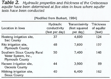
Estimated well yields from the Cretaceous aquifer where it is extensively used in Iowa are shown in figure 46. Here, estimated well yields range from less than 100 to slightly more than 1,000 gallons per minute; the range of estimated well yields probably is similar in Minnesota. Hydraulic-conductivity, transmissivity, and thickness values for the Cretaceous aquifer at five sites in Iowa are listed in table 2. Hydraulic-conductivity values ranged from 37 to 50 feet per day; transmissivity values ranged from 3,900 to 7,600 feet squared per day; and thickness values ranged from 89 to 162 feet.
GROUND-WATER QUALITY
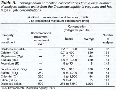
Water from the Cretaceous aquifer generally can be characterized
as a calcium magnesium sulfate type. The water typically is very
hard (hardness greater than 180 milligrams per liter as calcium
carbonate); hardness ranges from 22 to 1,600 milligrams per liter
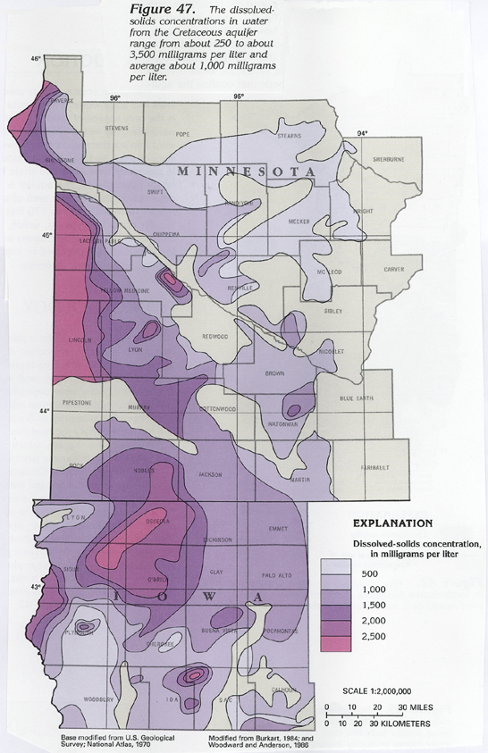
(table 3). Dissolved-solids concentrations
(fig. 47; table
3) range from 251 to 3,540 milligrams per liter. Many samples
contain concentrations of radionuclides (radium-226, radium-228)
in excess of the 5 picocuries per liter allowed in public water
supplies.
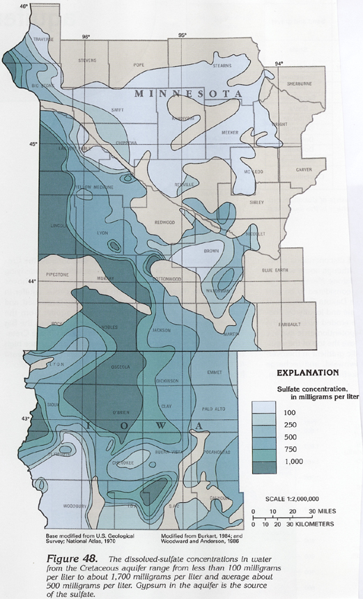
Dissolved-sulfate concentrations in water from the Cretaceous aquifer (fig. 48) exceed 1,000 milligrams per liter in large areas of Minnesota and Iowa and range from 0.5 to 1,700 milligrams per liter (table 3). Sulfate concentrations are generally greatest near recharge areas; this is the result of leaching of gypsum and other sulfate-bearing rocks by water entering the aquifer. Sulfate concentrations, which generally are least in areas of discharge, such as along the Big Sioux River in the southwestern part of the aquifer (fig. 45), might be a result of reduction of sulfate by anaerobic bacteria.
Iron and manganese also generally are present in large concentrations in water from the Cretaceous aquifer. Iron concentrations exceeded 300 micrograms per liter in about 80 percent of 28 samples collected in Iowa; manganese concentrations exceeded 50 micrograms per liter in about 56 percent of the same 28 samples.
Sodium concentrations in water from the Cretaceous aquifer are sufficiently small in Iowa to make the water generally acceptable for irrigation. Sodium concentrations range from 4.5 to 1,200 milligrams per liter (table 3). Water that has extremely large concentrations of sodium can only be applied to crops on well-drained soils and when there is adequate leaching time. Sodium concentrations in water from the Cretaceous aquifer in Minnesota range from 100 to 1,000 milligrams per liter. Large concentrations are attributed to ion exchange and the influx of saltwater from Cretaceous rocks in North and South Dakota.
FRESH GROUND-WATER WITHDRAWALS
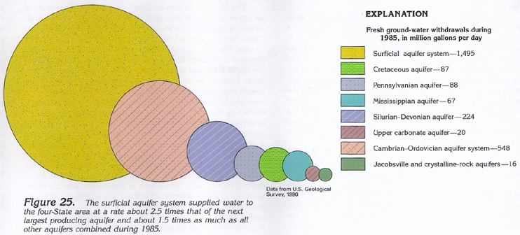
Fresh ground-water withdrawals from the Cretaceous aquifer during
1985 totaled 87 million gallons per day (fig.
49). Of the total, 10 million gallons per day was withdrawn
in southwestern Minnesota, and 77 million gallons per day in northwestern
Iowa. Withdrawals from the Cretaceous aquifer eceeded those from
the Mississippian aquifer in Segment 9 (67 million gallons per
day) and were nearly equal to the 88 million gallons per day withdrawn
from the Pennsylvanian aquifer (fig.
25).
About 50 percent of the water withdrawn from the Cretaceous aquifer was used for agricultural purposes (fig. 49), including irrigation. Public-supply use accounted for about 30 percent, and domestic and commercial uses accounted for about 14 percent. Only about 7 percent of the withdrawals was used for industrial, mining, or thermoelectric-power purposes.