INTRODUCTION
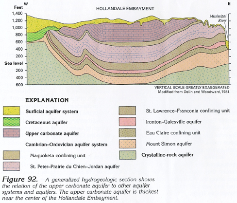
The upper carbonate aquifer is an important aquifer only in southeastern Minnesota and for a short distance into northeastern Iowa (fig. 91). It lies in the center of the Hollandale Embayment, which is a downwarped basin (fig. 92). As the name implies, the aquifer consists of carbonate rocks. The aquifer overlies an effective confining unit and is overlain and confined by the surficial aquifer system, except for a small area on the western edge that is overlain by Cretaceous rocks and along the eastern edge where the surficial aquifer system thins adjacent to the Driftless Area.
The upper carbonate aquifer consists of the upper part of a shale and carbonate rock sequence that forms the Maquoketa confining unit elsewhere in the segment. Fracturing and subsequent dissolution of a carbonate facies of the rock has produced the very productive upper carbonate aquifer.
HYDROGEOLOGY
The upper carbonate aquifer consists of limestone, dolomite, and
dolomitic limestone of the Devonian Cedar Valley Limestone and
the Ordovician Maquoketa Shale, Dubuque Formation, and Galena
Dolomite (fig. 93). The aquifer is
underlain by shale, dolomitic limestone, and limestone of the
Decorah Shale, the Platteville Formation, and the Glenwood Shale
that form an effective confining unit (fig.
93).
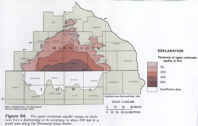
The upper carbonate aquifer ranges in thickness from a featheredge along its periphery to about 650 feet in a small area in the center of the embayment along the Minnesota-Iowa border (fig. 94). The rocks are extensively fractured and jointed, and numerous solution-enlarged rock openings, including sinkholes, solution cavities, and caves, have made the rocks extremely porous, especially in areas where glacial deposits are thin or missing. The aquifer extends a short distance into Iowa. In Iowa, however, dissolution has been inhibited and, therefore, little secondary permeability has developed in the rocks. This is because (1) the rocks are deeply buried, (2) there is a facies change from dolomite to shale in the Maquoketa Shale, and (3) the upper part of the Maquoketa contains shale units in Iowa that are not present in Minnesota. These rocks are not considered to be an aquifer in Iowa, and the southern limit of the aquifer has not been defined in the literature.
Regional ground-water flow in the upper carbonate aquifer generally is outward toward the periphery of the aquifer. The aquifer is recharged through the overlying surficial aquifer system that also acts as a leaky confining unit where it contains large quantities of clay and silt. Water movement is along short flow paths toward the many rivers that drain the area eastward to the Mississippi River, northwestward toward the Minnesota River, and southward into streams flowing into Iowa.
GROUND-WATER QUALITY
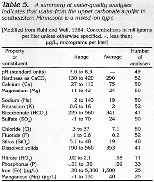
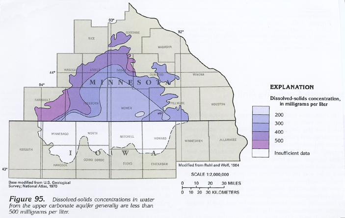
Water in the upper carbonate aquifer is a mixed ion type. Reported
dissolved-solids concentrations do not exceed 560 milligrams per
liter (table 5), and generally
range from 200 to 500 milligrams per liter (fig.
95). Values of properties and concentrations of constituents,
which generally meet those recommended for use of the water as
a public supply, are summarized in table
5.
The karstic nature of the upper carbonate aquifer and the thinness or absence of overlying glacial deposits along the eastern margin of the aquifer make this part of the aquifer susceptible to contamination from the land surface. The potential for contamination from the land surface in the central and the western parts of the aquifer is much less where thick till is present.
FRESH GROUND-WATER WITHDRAWALS
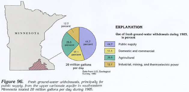
Fresh ground-water withdrawals from the upper carbonate aquifer
in southeastern Minnesota totaled 20 million gallons per day during
1985 (fig. 96). Withdrawals for public
supply, which is the principal use, accounted for about 8.9 million
gallons per day. Withdrawals for agricultural purposes, which
include irrigation, accounted for about 5.1 million gallons per
day, and those for domestic and commercial purposes, for about
3.4 million gallons per day; the remaining 2.6 million gallons
per day was used for industrial, mining, and thermoelectric-power
purposes.