REGIONAL SUMMARY
INTRODUCTION
This report provides a summary of ground-water conditions and problems in Illinois, Indiana, Kentucky, Ohio, and Tennessee, which compose Segment 10 of the Ground Water Atlas of the United States, an area of about 217,000 square miles. The definition, distribution, thickness, water-yielding, and water-quality characteristics of the principal aquifers in the segment are the primary topics of this chapter. Ground-water source, occurrence, movement, use, and problems also are discussed where appropriate.
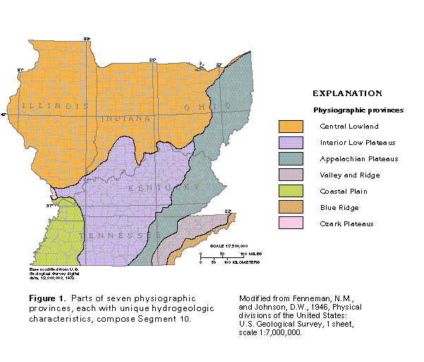
Segment 10 consists of parts of seven physiographic provinces (fig. 1)- the Coastal Plain, Blue Ridge, Valley and Ridge, Appalachian Plateaus, Interior Low Plateaus, Central Lowland, and Ozark Plateaus. The provinces have unique hydrogeologic characteristics that make it convenient to describe the principal aquifers in each province.
SOURCE OF GROUND WATER
The upper part of the rock mass that underlies Segment 10 generally contains fresh ground water, whereas the intermediate and lower parts generally contain saltwater. Freshwater is here defined as water that contains dissolved-solids concentrations of 1,000 milligrams per liter or less; the term "saltwater" is applied to water with dissolved-solids concentrations of greater than 1,000 milligrams per liter. For comparison, dissolved-solids concentrations in seawater are about 35,000 milligrams per liter. Water with concentrations of dissolved solids of greater than 35,000 milligrams per liter is called brine.
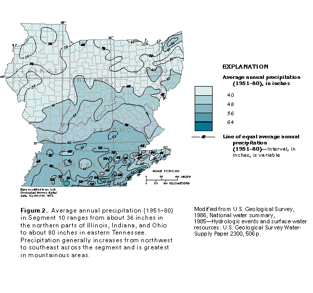
The source of the freshwater in Segment 10 is precipitation, primarily rain and snow. Long-term average annual precipitation in Segment 10 ranges from about 36 inches in the northern part of Illinois, Indiana, and Ohio to more than 80 inches in eastern Tennessee (fig. 2). Of the precipitation that falls on the five-State area, about 50 to 70 percent is returned to the atmosphere by evaporation from surface-water bodies and transpiration by plants. Much of the remainder constitutes runoff.
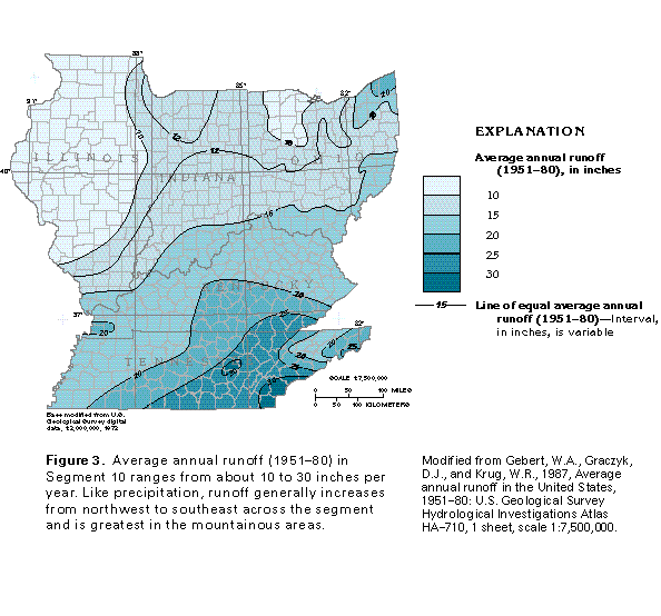
Long-term average annual runoff ranges from about 10 inches in some of the northern parts of the area to about 30 inches in some parts of central and southeastern Tennessee (fig. 3). Part of the runoff is direct surface runoff, and part is water that infiltrates the land surface, percolates to the water table, recharges the ground-water system, and moves through aquifers to discharge into streams as base flow.
Most of the precipitation that percolates downward and becomes ground-water recharge circulates through the shallow aquifers; only a small part enters the deep aquifers. Annual ground-water recharge is estimated to range from about 1 inch in parts of Illinois where precipitation is least and the permeability of the soil and rock at the land surface is low to as much as 13 inches in parts of Tennessee where precipitation is greatest and the permeability of materials at the land surface is high.
Saltwater is present at depths of 500 feet or less in much of Segment 10, particularly in aquifers in Paleozoic rocks. The source of the saltwater is assumed to be a combination of the fresh ground water and the seawater in which the rocks were deposited or by which they were later invaded. The dissolved-solids concentration in the saltwater increases with depth and reaches brine concentration in some parts of the segment. The brine might be derived from the solution of evaporite deposits or from ionic filtration by clay or shale beds during the process of sediment compaction or both.
PRINCIPAL AQUIFERS
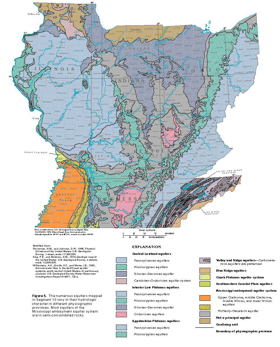
The rocks that underlie Segment 10 are divided into the different geohydrologic units (aquifers and confining units) shown in figures 4 and 5. These aquifers and confining units are grouped according to the physiographic provinces shown in figure 1 and are described in general accordance with these physiographic provinces.
Throughout Segment 10, the rocks that compose aquifers and confining units generally are divided into three types according to their degree of consolidation-the Precambrian and Paleozoic rocks are consolidated, the Cretaceous and Tertiary rocks generally are semiconsolidated, and the Quaternary deposits generally are unconsolidated. Exceptions are where carbonate cements have been dissolved from Paleozoic sandstone beds, which leaves them partly unconsolidated and friable, and where the younger unconsolidated deposits have been partly cemented or lithified. The consolidated rocks generally are covered with younger unconsolidated deposits or unconsolidated regolith derived from weathering of the consolidated rocks.
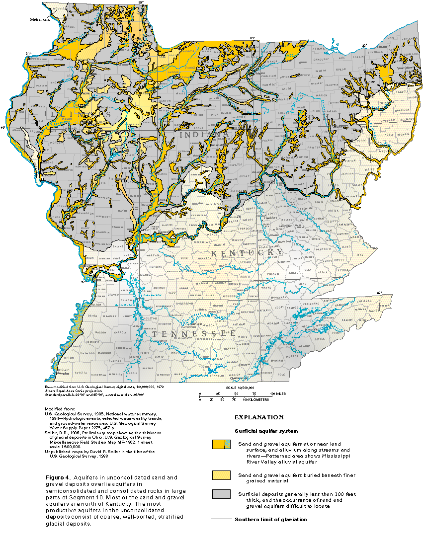
Unconsolidated, coarse-grained deposits of Quaternary age (primarily of glacial origin) compose principal aquifers that cover the Paleozoic rocks throughout most of the Central Lowland and the northern parts of the Interior Low Plateaus and Appalachian Plateaus Physiographic Provinces (figs. 1 and 4). Coarse-grained alluvium that has been derived from glacial material and deposited along present or buried major stream channels constitutes aquifers in the same areas. A band of alluvium parallel to the Mississippi River in westernmost Kentucky and Tennessee also composes an aquifer. Where the glacial deposits consist of coarse, well-sorted sand and gravel, they constitute some of the most productive aquifers in Segment 10. These unconsolidated deposits are collectively called the surficial aquifer system.
Semiconsolidated rocks of Cretaceous and Tertiary age compose principal aquifers in the Mississippi Embayment section of the Coastal Plain Province (figs. 1 and 5). Consolidated rocks of Paleozoic age compose principal aquifers in the Central Lowland, the Interior Low Plateaus, the Appalachian Plateaus, the Valley and Ridge, and the Ozark Plateaus Provinces. Consolidated rocks of Precambrian age compose principal aquifers of the Blue Ridge Province.
GEOLOGIC SETTING
To a large extent, the geology of the area controls the occurrence, movement, availability, and quality of the ground-water resources. Thus, a basic understanding of the geology is necessary to understand the ground-water hydrology.
Precambrian igneous, metamorphic, and sedimentary rocks are at the land surface in the Blue Ridge Province in eastern Tennessee. Elsewhere in Segment 10, Precambrian igneous and metamorphic rocks are buried beneath younger rocks. The top of the Precambrian rocks is about 1,000 feet below sea level in northern Illinois and is about 15,000 feet below sea level at the junction of Illinois, Indiana, and Kentucky.
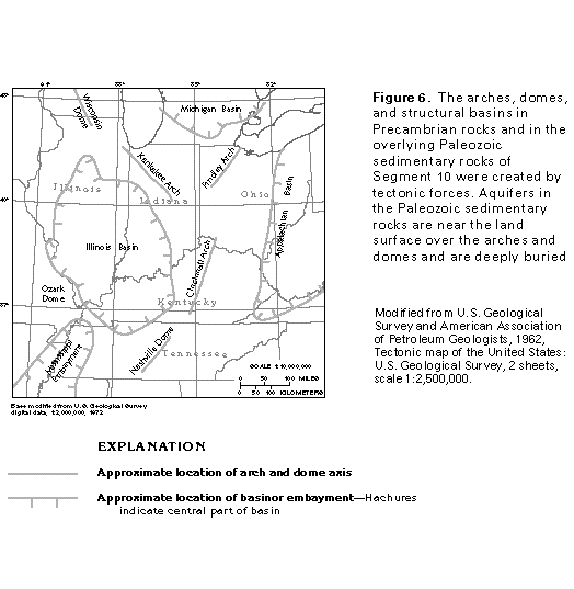
A thick sequence of consolidated sedimentary rocks of Paleozoic age overlies the Precambrian rocks. These sedimentary rocks are primarily siltstone, shale, sandstone, limestone, and dolomite. Tectonic forces warped the deeply buried Precambrian rocks and created arches, domes, structural basins, and fracture systems in the overlying Paleozoic rocks (fig. 6). On the crests and flanks of the arches and domes, freshwater can be obtained from water-yielding rocks that are either exposed at the land surface or buried at shallow depths. The same water-yielding rocks are deeply buried in the structural basins and mostly contain saltwater or brine.
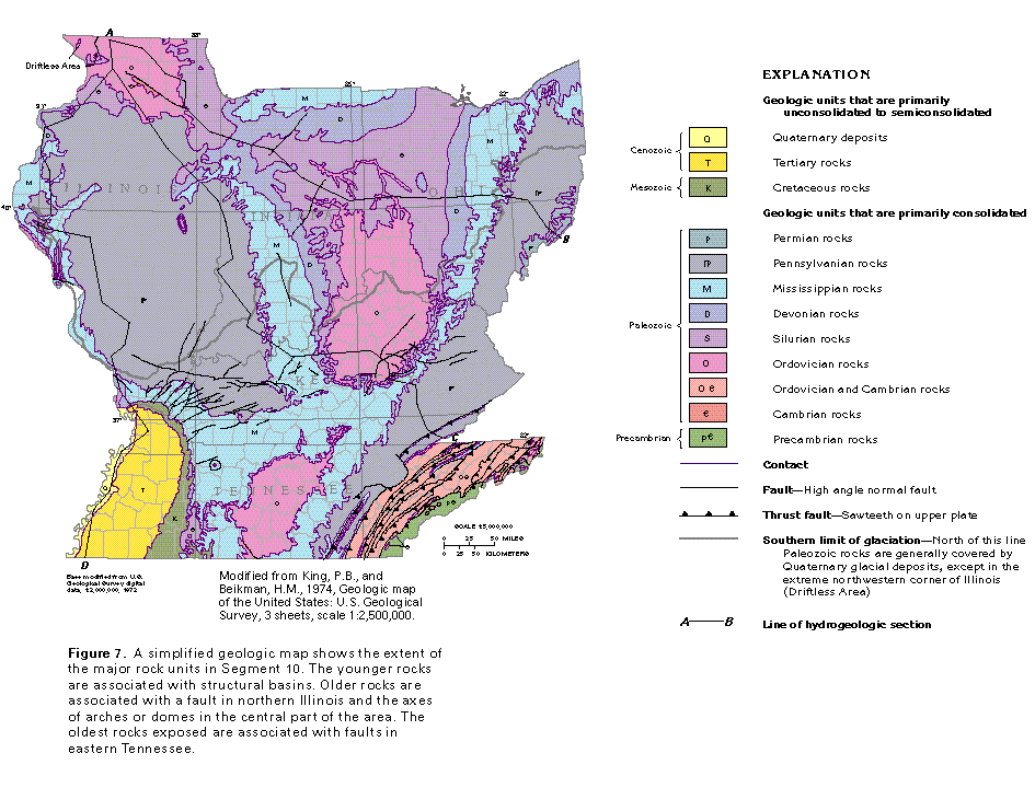
The distribution of the Paleozoic rocks in the area is controlled by the position of the arches, domes, structural basins, and associated faults. The oldest Paleozoic rocks (Cambrian) are at the land surface between northeast-trending thrust faults in the Blue Ridge and the Valley and Ridge Provinces in eastern Tennessee. Cambrian strata also subcrop below Quaternary deposits and locally crop out in a small area south of a normal fault in northern Illinois (fig. 7). Ordovician rocks either are at the land surface or subcrop over the arches and domes, where rocks younger than Ordovician were either eroded or never deposited. The youngest Paleozoic rocks (Pennsylvanian and Permian) are present in the areas coincident with the structural basins (figs. 6 and 7). Pennsylvanian strata are present in the Illinois Basin in central and southern Illinois, southwestern Indiana, and northwestern Kentucky. Pennsylvanian and Permian strata are present in the Appalachian Basin in southeastern Ohio, whereas only Pennsylvanian strata are present in the same basin in eastern Kentucky and east-central Tennessee.
The Paleozoic rocks are covered by sedimentary rocks of late Mesozoic and Cenozoic age in the Mississippi Embayment section of the Coastal Plain Province in the western parts of Kentucky and Tennessee and in southern Illinois (figs. 1 and 7). These Coastal Plain deposits thicken from less than 100 feet near their northern and eastern limits to about 3,000 feet at the southwestern tip of Tennessee. The deposits are primarily semiconsolidated layers of clay, silt, and sand.
In the northern part of Segment 10, the Paleozoic rocks are covered by Quaternary deposits, which consist of different combinations of clay, silt, sand, and gravel. Most of these materials were deposited by the ice of continental glaciers that covered large parts of North America during the Pleistocene Epoch or by meltwater from the ice. The southern limit of glaciation (fig. 7) marks the general southern extent of these deposits in Segment 10, but meltwater deposits are present south of this limit along the Ohio River and many of its tributaries.
The distribution of the different geologic units at depth is shown by the geologic sections in figure 8. From this perspective, the effects of arches, domes, structural basins, and asso-ciated faults on the distribution of the rocks in Segment 10 are more apparent.
FRESH GROUND-WATER WITHDRAWALS
Ground water is a reliable source of freshwater for about 15 million people, or 44 percent of the total population, in the five-State area of Segment 10. Public water-supply systems provide water to twice as many people as do domestic wells. During 1985, the people of Illinois used the most ground water (about 930 million gallons per day), and those in Kentucky used the least (about 205 million gallons per day). These data provide an indication of the magnitude of the fresh ground water withdrawn by public and rural water-supply systems.
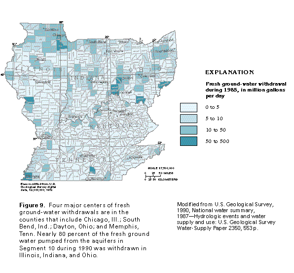
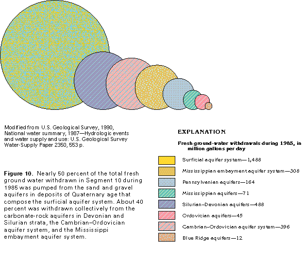
Fresh ground-water withdrawals during 1990 in Segment 10 are illustrated by county in figure 9. The total withdrawal values shown in figure 9 account for all categories of water use-public supply, domestic and commercial, agricultural, and combined industrial, mining, and thermoelectric power. Withdrawals are greatest near large population centers or areas where industry is concentrated or both. Most of the areas of large withdrawals in Segment 10 are in Illinois, Indiana, and Ohio. The four largest withdrawal areas are located around Chicago, Ill., South Bend, Ind., Dayton, Ohio, and Memphis, Tenn. The rate of fresh ground-water withdrawals from the principal aquifers in Segment 10 during 1985 is shown in figure 10. During 1985, about 1,488 million gallons per day was withdrawn from the surficial and buried sand and gravel aquifers in deposits of Quaternary age, which are located primarily along and north of the Ohio River. These aquifers supplied about 3 to 125 times as much water as other aquifers in the segment and yielded about one-half of the total fresh ground water withdrawn. Other productive aquifers or aquifer systems that supplied at least 300 million gallons per day during 1985 are the limestone and dolomite aquifers in rocks of Devonian and Silurian age (about 488 million gallons per day), the Cam-brian-Ordovician aquifer system (about 396 million gallons per day), and the Mississippi embayment aquifer system (about 308 million gallons per day). The Mississippi embayment aquifer system is the principal source of fresh ground water for the westernmost parts of Kentucky and Tennessee. During 1985, the total ground water withdrawn from all the aquifers in Segment 10 was about 2,972 million gallons per day.