APPALACHIAN PLATEAUS AQUIFERS
INTRODUCTION
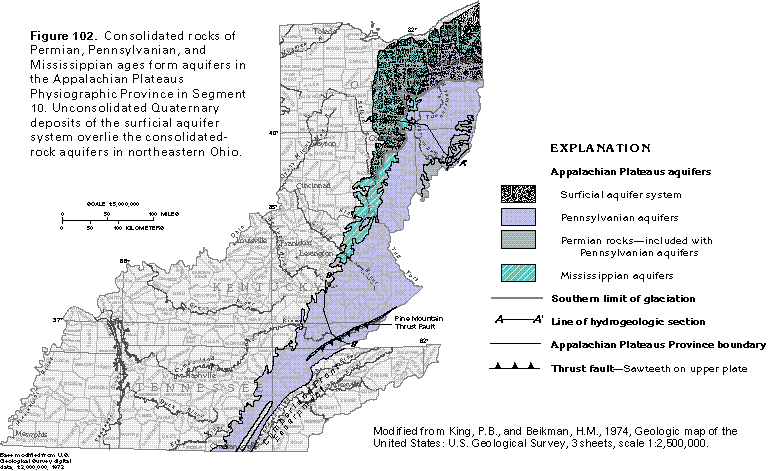
The part of the Appalachian Plateaus Physiographic Province included in Segment 10 is present in the eastern parts of Ohio, Kentucky, and Tennessee (fig. 102). The eastern boundary of the province coincides with the Cumberland Front Escarpment in Kentucky and Tennessee. North of the escarpment, the province extends into the western parts of Virginia, West Virginia, and Maryland and into western and northern Pennsylvania, all of which are described in Segment 11 of this Atlas. The part of the province that extends into western and southern New York is discussed in Segment 12 of this Atlas. The province extends southward into northeastern Alabama and northwestern Georgia for a short distance; this extension is described in Segment 6 of this Atlas. The western boundary of the province in Segment 10 approximately coincides with the contact between Devonian and Mississippian rocks in northeastern Kentucky and Ohio and with the contact between Mississippian and Pennsylvanian rocks farther south.
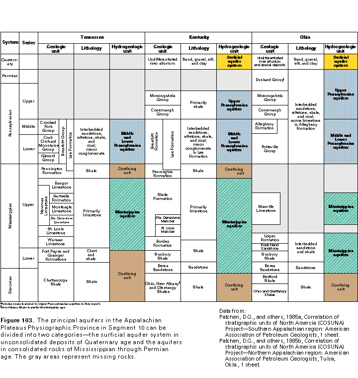
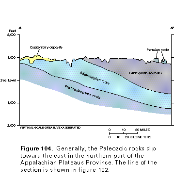
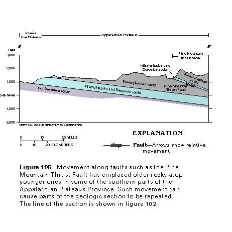
Aquifers in the Appalachian Plateaus Physiographic Province can be divided into two categories-the surficial aquifer system in unconsolidated deposits and the aquifers in consolidated rocks (fig. 103). The sand and gravel of the surficial aquifer system overlie the aquifers in consolidated rocks in much of northeastern Ohio and along the Ohio River and its tributaries. The aquifers in consolidated rocks consists of sedimentary bedrock that ranges in age from Mississippian through Permian. Generally, these consolidated rocks dip toward the east (fig. 104) and are present throughout the Appalachian Plateaus Province. In places, Pennsylvanian and older rocks are cut by thrust faults (fig. 105) along which thick sections of older rocks have been displaced over younger strata. One effect of this type of faulting is that parts of the geologic column are repeated; for example, the sequence of Devonian through Pennsylvanian rocks on the right side of the section shown in figure 105 has been pushed westward along the Pine Mountain Thrust Fault. A deep well drilled on the Pine Mountain Fault Block might penetrate the Pennsylvanian-Devonian sequence twice.
HYDROGEOLOGIC UNITS
Surficial Aquifer System
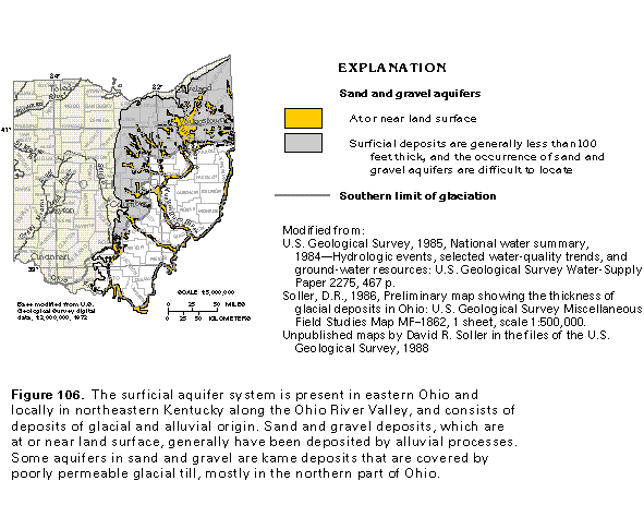
The surficial aquifer system consists of sand and gravel deposits of glacial and alluvial origin. Some of the glacial material was deposited directly by the ice, and some was deposited by meltwater. The coarse-grained glacial material that constitutes productive aquifers was deposited as alluvium, which filled bedrock valleys, and as kame deposits enclosed within or buried beneath glacial till. The alluvial material is along present-day streams and consists mostly of reworked glacial deposits. Aquifers that consist of sand and gravel beds in the glacial and alluvial deposits are locally present throughout eastern Ohio and in northeastern Kentucky along the Ohio River (fig. 106). Wells completed in the sand and gravel deposits, which are highly permeable, yield more water than wells completed in any of the other aquifers in the Appalachian Plateaus Province. As a result, ground-water development in Ohio has primarily focused on the coarse-grained alluvial and glacial deposits.
The aquifers of the surficial aquifer system are of two types-alluvium that is in present-day stream valleys and glacial out-wash or valley-train deposits in buried bedrock valleys and kame deposits that consist of sand and gravel surrounded by or buried beneath poorly permeable glacial till. In many stream valleys, stratified glacial drift, consisting of sand, gravel, and clay, was deposited by meltwater as the glaciers retreated. Today, most of these valleys are occupied by perennial streams. Sand and gravel deposits in the valleys are the primary aquifer materials, and their locations are easy to predict because they are located at or near land surface. These deposits commonly range from 25 to 200 feet in thickness but may exceed 300 feet in large stream valleys. The kame deposits cover the northern Ohio part of the Appalachian Plateaus Province (fig. 106). Fine-grained glacial till might enclose or cover these local, lens-shaped sand and gravel aquifers, thus making the aquifers difficult to locate.
Pennsylvanian Aquifers
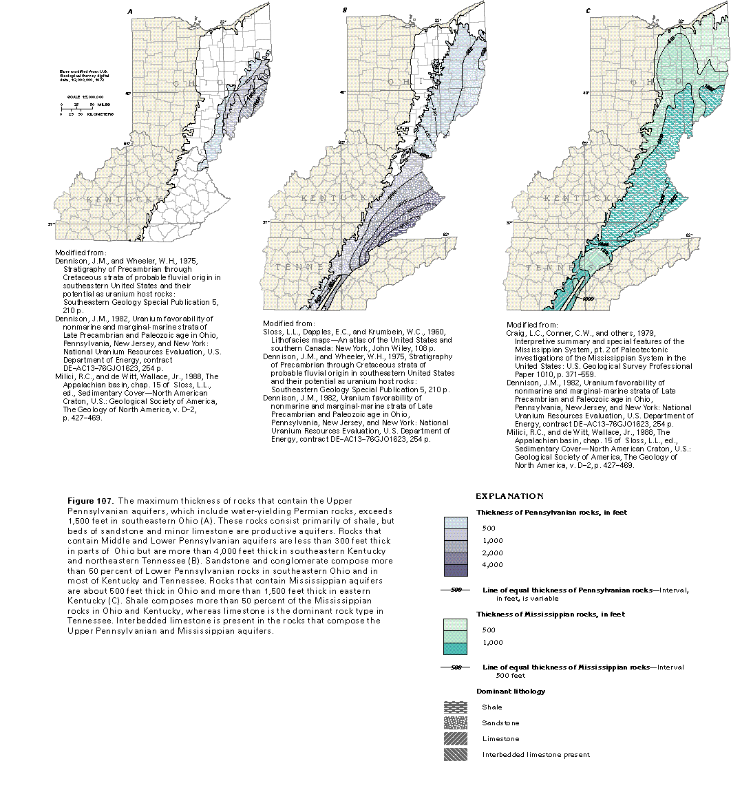
Pennsylvanian aquifers in the Appalachian Plateaus Province mostly consist of sandstone and limestone that are parts of repeating sequences of beds deposited during multiple sedi-mentary cycles. A complete, ideal cycle consists of the following sequence of beds, listed from bottom to top: underclay, coal, gray shale or black platy shale, freshwater limestone, and sandstone or silty shale. Not all the beds listed are present in each cycle. The sandstones and limestones are the most productive aquifers. Sandstone aquifers also are present in rocks of Permian age. In the following description, rocks of Pennsylvanian age are grouped into Upper Pennsylvanian aquifers and Middle and Lower Pennsylvanian aquifers; water-yielding rocks of Permian age are discussed with the Upper Pennsylvanian aquifers.
Upper Pennsylvanian aquifers mostly are present in the Pennsylvanian Monongahela and Conemaugh Groups but also can include sandstones of the Dunkard Group of Pennsylvanian and Permian age (fig. 103). Strata that contain these aquifers are present in southeastern Ohio and a small part of northeastern Kentucky (fig. 107A). In southeastern Ohio, Upper Pennsylvanian rocks are primarily interbedded sandstone, siltstone, and shale with minor coal; they grade to shale and siltstone in northeastern Kentucky. The dominant lithology is shale, although some limestone beds are present in the Monongahela Group. Together, the Monongehela and the Conemaugh Groups average about 1,000 feet in thickness. These rocks thicken slightly toward the southeast and exceed 1,500 feet in thickness along the Ohio River in Belmont, Monroe, and Washington Counties, Ohio, where they include the Dunkard Group.
Middle and Lower Pennsylvanian aquifers crop out throughout most of the Appalachian Plateaus Province in Segment 10 and are the most widespread source of ground water in the province. Shale with interbedded sandstone is the dominant lithology of Middle and Lower Pennsylvanian rocks in the northern part of the province, whereas sandstone is dominant in the south (fig. 107B). Rocks that compose the Middle and Lower Pennsylvanian aquifers include the Allegheny Formation and the Pottsville Group in Ohio, the Breathitt and the Lee Formations in Kentucky, and several equivalent formations in Tennessee (fig. 103). The Allegheny Formation and the Pottsville Group are primarily interbedded sandstone, siltstone, and shale but contain economically important beds of coal. An average of about 40 percent of the total thickness of the Pottsville Group is sandstone. In Kentucky, the Breathitt Formation is pri-marily interbedded sandstone, siltstone, and shale, whereas the Lee Formation is predominantly sandstone with some con-glomerate. Beds of sandstone in the Breathitt Formation are typically from 30 to 120 feet thick and compose about 50 percent of the total thickness of the formation. About 80 percent of the total thickness of the Lee Formation consists of beds of sandstone and conglomerate. Middle and Lower Pennsylvanian rocks in Tennessee are predominately interbedded conglomerate and sandstone with some siltstone, shale, and coal beds. The primary water-yielding units are sandstone and conglomer-ate beds in the Crab Orchard Mountains Group; some conglomerate beds in this group locally are 200 feet thick, whereas sandstone beds in the group range from 100 to 300 feet thick and are locally conglomeratic.
Mississippian Aquifers
Mississippian aquifers in the Appalachian Plateaus Province in Segment 10 consist mostly of limestone and sandstone. Fractured chert of the Fort Payne Formation in Tennessee locally forms an aquifer. Shale is more abundant in Mississippian strata in Ohio and Kentucky than sandstone and limestone, whereas limestone is more prevalent in Tennessee (fig. 107C). The Mississippian aquifers are exposed at land surface along and east of the western boundary of the Appalachian Plateaus Province in Ohio and northern Kentucky and locally in southeastern Kentucky and northeastern Tennessee along the Pine Mountain Thrust Fault.
The Black Hand and the Berea Sandstones (fig. 103) are the primary Mississippian aquifers in Ohio. Although the Berea is Devonian age in part, it is included in the Mississippian aquifers in this chapter. The thickness of the Black Hand locally exceeds 600 feet and that of the Berea locally exceeds 100 feet. The Berea Sandstone also is a productive aquifer in northern Kentucky. The Ste. Genevieve and the St. Louis Members of the Slade Formation are productive aquifers in central and southern Kentucky, particularly in stream valleys where they are covered only by a thin layer of Pennsylvanian rocks and unconsolidated alluvial deposits. In Tennessee, the Monteagle, the St. Louis, the Warsaw, and the Newman Limestones, as well as the Fort Payne and the Grainger Formations, compose productive Mississippian aquifers.
GROUND-WATER OCCURRENCE AND MOVEMENT
Surficial Aquifer System
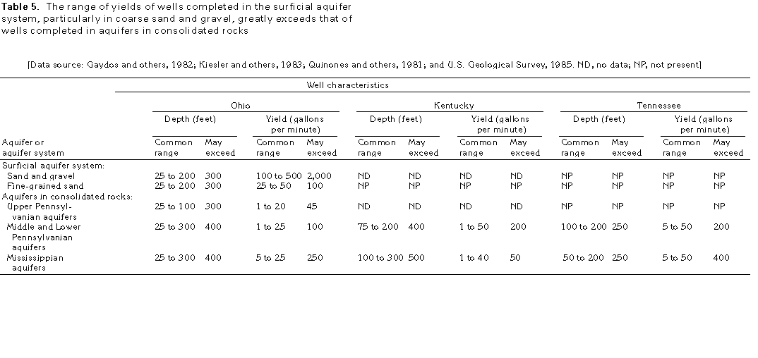
Sand and gravel aquifers of the surficial aquifer system in Ohio are the most productive aquifers in the Appalachian Plateaus Province in Segment 10 because the aquifers are highly permeable and easily recharged. Generally, these aquifers are either exposed at land surface or buried at shallow depths and thus are directly recharged by precipitation. In many places, the aquifers are hydraulically connected to streams, which provide recharge to the aquifers near places where wells that withdraw water from an aquifer have lowered the water level in the aquifer below that of the stream. Well yields in sand and gravel deposits commonly range from 100 to 500 gallons per minute but might exceed 2,000 gallons per minute (table 5).
Aquifers that consist of fine sand and silt also are common in Ohio but generally are less permeable than aquifers that consist of coarse sand and gravel. Yields of wells completed in these finer grained aquifers commonly range from 25 to 50 gallons per minute. Generally, these aquifers are present in the fill of abandoned stream valleys and as lenses within layers of glacial till; therefore, the aquifers typically are not in direct hydraulic connection with streams.
Aquifers in Consolidated Rocks
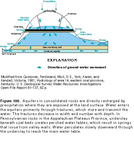
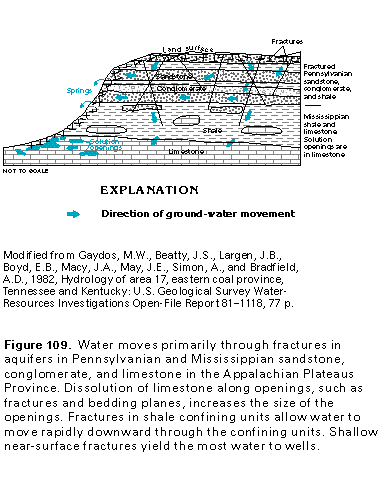
Aquifers in consolidated rocks are an important source of ground water, especially where wells penetrate fractures that store and transmit water, where sandstone beds are hydraulically interconnected, near outcrop areas where recharge is direct and drilling depths are minimal, and in stream valleys where alluvial deposits that overlie the consolidated rocks store recharge and subsequently slowly release water to the aquifers. The aquifers in consolidated rocks are directly recharged by precipitation where they are exposed at land surface (fig. 108). However, low-permeability layers of underclay beneath coal beds retard downward movement of the water and might create perched water-table conditions above the main water table. The perched water discharges mainly to springs; the main water table discharges to streams, as well as springs. Water in deep artesian aquifers might be part of a regional flow system with a different flow direction than the shallower ground-water flow systems.
Water in the consolidated-rock aquifers of the Appalachian Plateaus Province is primarily in fractures in sandstones and shales and in fractures or bedding planes enlarged by dissolution in limestones. Fractured coal beds also yield water in some places. Because these consolidated rocks have little or no intergranular permeability, fractures store and transmit most of the ground water. The fractures generally are at shallow depths; most are a few tens to a few hundreds of feet below land surface. These fractures commonly form where erosion has removed overlying rocks, thus relieving vertical compressional stress and along the crest of anticlinal folds. The number of fractures and the width of individual fractures generally decrease as depth increases. Although fractures are present throughout the consolidated rocks of the Appalachian Plateaus, aquifer characteristics of the rocks and well yields are variable because the effective permeability of the rocks is dependent, for the most part, upon the number of fractures and how well the fractures are interconnected. Low intergranular permeability, coupled with the decrease in the size and number of fractures as depth increases, restricts the regional flow of water and creates conditions in which well yields generally are small.
Sandstone, limestone, and conglomerate are the dominant water-yielding rocks that compose Upper Pennsylvanian aquifers, but beds of fractured coal locally provide small supplies of water. Individual sandstone beds in Upper Pennsylvanian rocks generally are of limited areal extent and are isolated from other sandstone beds. The discontinuous occurrence and the generally fine-grained texture of the unfractured rocks and sparse fracture openings combine to impede the flow of ground water. Ground water in these aquifers generally moves from recharge areas downgradient to discharge at streams, wells, and coal mines. Perched water tables above clay layers that underlie coal beds in the upland areas give rise to springs along valley walls (fig. 108). Well yields from Upper Pennsylvanian aquifers commonly range between 1 and 20 gallons per minute in Ohio (table 5).
Middle and Lower Pennsylvanian rocks generally contain more sandstone and conglomerate than Upper Pennsylvanian rocks. Some of the Middle and Lower Pennsylvanian sandstone and conglomerate beds are regionally extensive and contain well-developed fracture systems. These fractures increase the overall yield of Middle and Lower Pennsylvanian aquifers compared to Upper Pennsylvanian aquifers (table 5). Perched water tables can occur above underclays in Middle and Lower Pennsylvanian aquifers but are less common than in Upper Pennsylvanian aquifers. In Kentucky and Tennessee, sandstone and conglomerate in Middle and Lower Pennsylvanian rocks tend to be thickly bedded or massive, and extend over large areas. Well yields from Middle and Lower Pennsylvanian aquifers only range from 1 to 25 gallons per minute in Ohio but range from 5 to 50 gallons per minute in Tennessee.
Mississippian aquifers are mostly in limestones, except in Ohio where they are mostly in sandstones. Slightly acidic water that moves along fractures, bedding planes, and other primary openings in limestone dissolves part of the limestone and enlarges the original openings (fig. 109). The maximum reported yields of wells completed in these aquifers are highly variable; wells that penetrate solution openings in the limestone have large yields (table 5). In Ohio, withdrawals from Mississippian aquifers can induce recharge from the directly overlying surficial aquifer system. In these areas, yields of wells com-pleted in the Mississippian aquifers can be greater than elsewhere. Mississippian aquifers also are an important source of water in stream valleys where the overlying Pennsylvanian rocks are thin or absent. In stream valleys, recharge from alluvial valley fill tends to increase yields of wells completed in the underlying Mississippian aquifers. In Tennessee and Kentucky, springs can discharge from valley walls at the contact between Pennsylvanian and Mississippian rocks (fig. 109). Water percolates downward through the Pennsylvanian sandstones and then flows laterally along the contact with less-permeable Mississippian shale to emerge as springs along the valley walls.
GROUND-WATER QUALITY
The quality of ground water from the aquifers in the Appalachian Plateaus Province in Segment 10 generally is suitable, with minimal treatment for most uses. Chlorination is usually the only treatment required to make the water suitable for drinking. Locally, excessive concentrations of iron or sulfate may be present. Water from the surficial aquifer system and the aquifers in consolidated rocks may be locally contaminated by saltwater present at shallow depths or by human activities, such as the disposal of wastes or development of the coal, oil, and gas resources of the area.
Surficial Aquifer System
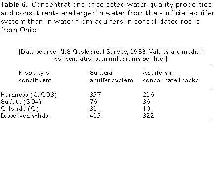
Water from the surficial aquifer system in the Appalachian Plateaus Province in Ohio is predominantly a calcium bicarbonate type. The water generally has larger concentrations of dissolved solids, chloride, and sulfate and is harder than water from the aquifers in consolidated rocks in the same area (table 6). Iron concentrations also tend to be larger in water from the surficial aquifer system and generally increase with depth.
Aquifers in Consolidated Rocks
The principal factors that govern the chemical quality of ground water in the aquifers in consolidated rocks are aquifer mineralogy and residence time (the amount of time the water has been in contact with the rocks). Water from sandstone aquifers that contain few soluble minerals generally is soft, whereas hard water is obtained from limestone or shale that contain more of the soluble minerals calcite and dolomite. Water in the deeper parts of the aquifers tends to be more mineralized than water from shallow depths because the deeply circulating water generally has followed longer flow paths and has been in contact with aquifer minerals for a longer period of time. Generally, water from wells located in recharge areas on ridges is less mineralized than elsewhere because of a shorter residence time in the aquifer. Water from wells located in valleys where discharge occurs is more mineralized than elsewhere. Water from areas where coal and black shale are close to the land surface tends to be acidic, whereas water from limestone tends to be alkaline.
Chloride concentrations can be large in water from aquifers in consolidated rocks beneath valley bottoms because of deep circulation of the water to zones at or near the saltwater-freshwater interface and the subsequent rise of the mixed water along fractures. In addition, saltwater is relatively common at shallow depths in the vicinity of oil and gas fields because saltwater can migrate upward through improperly plugged, corroded, or abandoned oil and gas test wells. This type of contamination has been reported near Keaton in Johnson County, Ky.
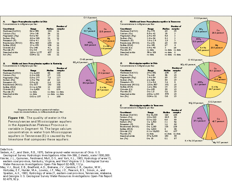
Water from the Pennsylvanian and the Mississippian aquifers in Ohio generally is either a calcium magnesium bicarbonate type or a calcium sodium bicarbonate type (figs. 110A and 110D). Thin shale beds are present between the sandstone and limestone aquifers in these rocks. The shales contain calcite and siderite (an iron carbonate mineral). These minerals, along with the calcite and minor dolomite in the limestone beds, are the source of the calcium and magnesium.
In Kentucky, water from wells completed in the Middle and Lower Pennsylvanian aquifers commonly is a calcium sodium bicarbonate type (fig. 110B). Water from the aquifers in Mississippian rocks in Kentucky is a slightly alkaline, calcium bi-carbonate type. Excessive hardness and large concentrations of iron, chloride, and sulfate are locally present in water from the Pennsylvanian and the Mississippian aquifers.
Saltwater, defined in this Atlas as water that has a dissolved-solids concentration of more than 1,000 milligrams per liter, generally is at depths greater than 300 feet below land surface in Kentucky. However, saltwater is at depths of less than 100 feet below land surface in valleys of large rivers and their principal tributaries. Locally, however, freshwater is reported to be present at great depths in areas in Kentucky adjacent to major faults; for example, chloride concentrations of only 2 milligrams per liter were present in water from two wells reported to be 1,500 feet deep in Bell County, Ky. Freshwater probably circulated to this depth in fractures or steeply dipping bedding planes associated with the Pine Mountain Thrust Fault.
Sparse data indicate that water from Pennsylvanian aquifers in Tennessee ranges from soft to hard, is a mixed type (no anion or cation is dominant), and contains small concentrations of dissolved solids (fig. 110C). In contrast, water from Mississippian aquifers, which are mostly limestone, generally is a calcium bicarbonate type (fig. 110E) and is harder and more mineralized than water from Middle and Lower Pennsylvanian aquifers. Large concentrations of sulfate locally are present in water from wells completed in Mississippian rocks.
Effects of Coal Mining and Reclamation on Ground-Water Quality
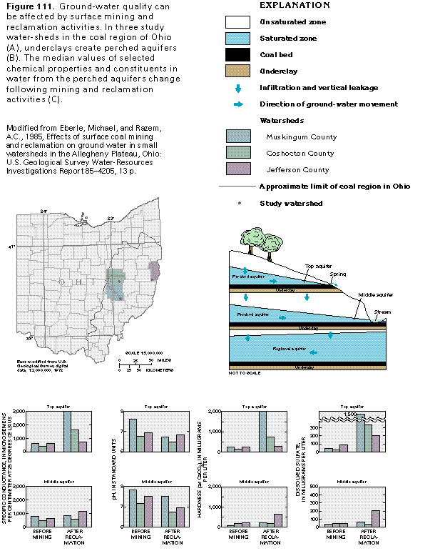
Surface coal mining and reclamation activities can affect the quality of ground water. Changes in ground-water quality that can occur as a result of mining and reclamation are characterized below for three small watersheds in eastern Ohio (fig. 111A).
The ground-water flow system in coal mining areas generally is controlled by underclays that typically are present beneath each of several coal beds (fig. 111B). These under-clays impede the vertical flow of water to underlying aquifers, thereby creating one or more perched aquifers. In the example shown in figure 111B, two perched aquifers overlie a regional aquifer in which the direction of ground-water movement is different from that in the perched aquifers. Water moves laterally along the top of the underclays and discharges as springs or seeps where the clay crops out in valley walls. In this example, during surface mining of the uppermost coal, the aquifer material and the coal bed overlying the shallowest underclay is removed and replaced with broken waste rock (spoil material) as part of the reclamation process.
The quality of the water in the aquifers can be altered by mining activity. In this example, water in the top aquifer undergoes many water-quality changes as a result of mining and reclamation. Water in the middle aquifer undergoes some chemical changes, and water in the deeper, regional aquifer undergoes no significant water-quality changes. Water in the top aquifer generally changed from a calcium bicarbonate type to a calcium sulfate type. Hardness, specific conductance (an indirect measure of the concentration of dissolved solids), and sulfate in water from the top aquifer increased after reclamation (fig. 111C). Changes in the chemical quality of the water from the middle aquifer are less pronounced, and no significant changes occur in the quality of water from the regional aquifer. Chemical changes that result from mining can be quite different in other places from those shown in this example. The exact changes also depend on the chemical composition of the coal and the spoil material.
FRESH GROUND-WATER WITHDRAWALS
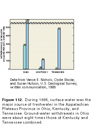
Ground water is an important source of freshwater in the Appalachian Plateaus Province of Segment 10. Ohio withdrew the largest quantity of ground water during 1985-about eight times the quantity withdrawn by Kentucky and Tennessee combined (fig. 112). However, surface-water use greatly exceeded ground-water use in all three States.
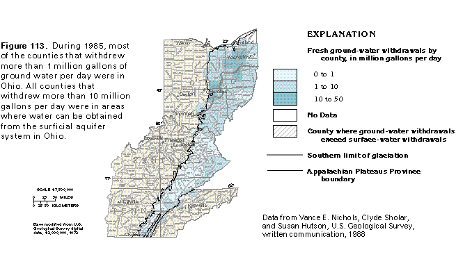
The distribution of ground-water withdrawals by county during 1985 (fig. 113) shows that Ohio withdrew the largest quantity of ground water and had the most counties in which ground-water withdrawals exceeded surface-water withdrawals. Seven counties in Ohio that had withdrawals of greater than 10 million gallons per day are located where glacial and alluvial deposits of the surficial aquifer system are present. These aquifers are the major sources of ground water because they have the largest well yields of any aquifers in the Appalachian Plateaus Province and because many of Ohio's urban areas are located near major streams whose valleys are filled with sand and gravel deposits of the surficial aquifer system. Many water systems in Ohio use water from the surficial aquifer system and the aquifers in consolidated rocks for their freshwater supply.
Despite their generally lower yields, the aquifers in consolidated rocks are important sources of water. In Ohio, Upper Pennsylvanian aquifers provide domestic supplies, and Mississippian aquifers provide domestic and small public supplies. Middle and Lower Pennsylvanian aquifers are used primarily for domestic, stock, and small public and industrial supplies throughout the Appalachian Plateaus Province.
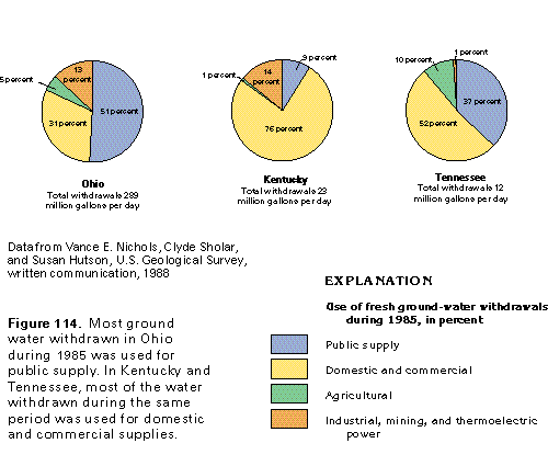
During 1985, most of the ground water withdrawn in Ohio (51 percent of total withdrawals) was used for public supply (fig. 114); withdrawals for domestic and commercial uses accounted for 31 percent. In contrast, most of the ground water in Kentucky (76 percent) and Tennessee (52 percent) was withdrawn for domestic and commercial uses, followed by withdrawals for industrial, mining, and thermoelectric power uses (14 percent) in Kentucky and public-supply uses (37 percent) in Tennessee. Water needs of industry are apparent in Ohio and Kentucky where withdrawals for industrial, mining, and thermo-electric power uses made up a significant percentage of the total ground water withdrawn.