MISSISSIPPI EMBAYMENT AQUIFER SYSTEM
INTRODUCTION
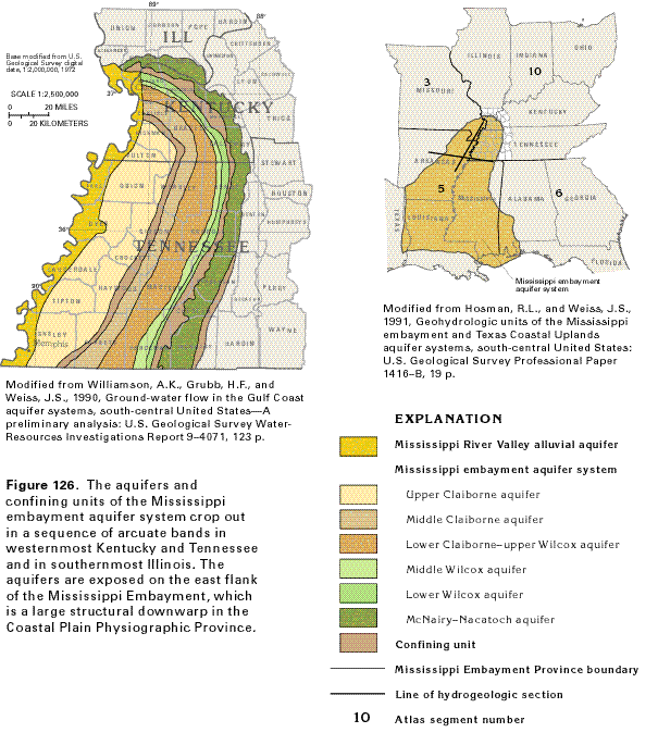
The aquifers that compose the Mississippi embayment aquifer system (fig. 126) are located in the southwestern part of Segment 10 on the eastern side of the Mississippi Embay-ment section of the Coastal Plain Physiographic Province. These aquifers consist of unconsolidated to semiconsolidated sediments that range in age from Late Cretaceous through late Eocene. They are a major source of freshwater, whereas consolidated rocks of Ordovician through Precambrian age that underlie these aquifers contain saltwater. The Mississippi embayment aquifer system is present in parts of Alabama, Arkansas, Florida, Illinois, Kentucky, Louisiana, Mississippi, Missouri, and Tennessee. It is areally extensive in Segment 5 and is discussed in greater detail in the Atlas Chapter describing that segment.
HYDROGEOLOGIC UNITS
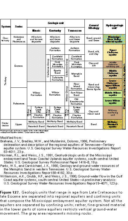
Six aquifers and two confining units compose the Mississippi embayment aquifer system in Segment 10 (fig. 127). The Mississippi River Valley alluvial aquifer, which consists of sediments of Quaternary age, is present in a narrow band along the Mississippi River (fig. 126); it overlies the Mississippi embayment aquifer system and is in hydraulic contact with the system. East of this band, the five aquifers in Tertiary rocks that compose the Mississippi embayment aquifer system cover a wide part of the Coastal Plain of Kentucky and Tennessee. In descending order, these aquifers are the upper Claiborne aquifer (which is underlain by the middle Claiborne confining unit), the middle Claiborne aquifer, the lower Claiborne-upper Wilcox aquifer, the middle Wilcox aquifer, and the lower Wilcox aquifer. The McNairy-Nacatoch aquifer, which lies beneath the Midway confining unit, consists of sediments of Cretaceous age and occurs as a band at or near the eastern edge of the Coastal Plain Province in Illinois, Kentucky, and Tennessee.
The aquifers in the Mississippi embayment aquifer system are defined on the basis of changes in lithology and hydraulic head (water level) between aquifers. Some of these aquifers are separated by areally extensive confining units-the middle Claiborne and the Midway confining units (fig. 127)-that consist of fine-grained sediments that restrict the vertical movement of water between aquifers. Other aquifers that are not separated by confining units contain interbedded fine-grained sediments that restrict vertical flow within and between the aquifers.
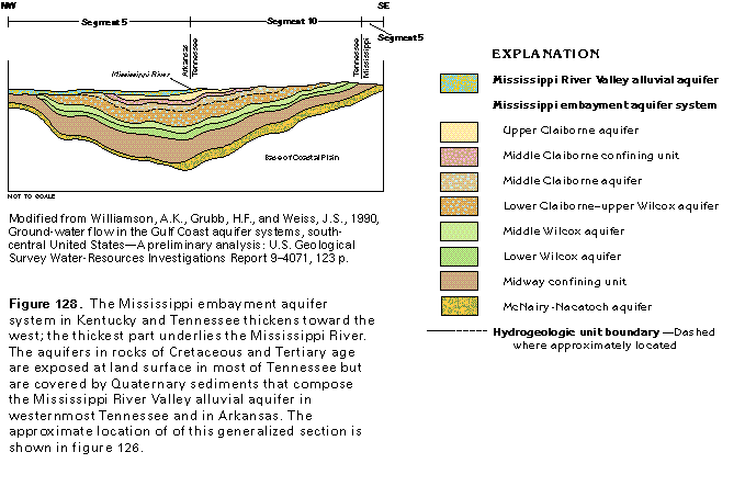
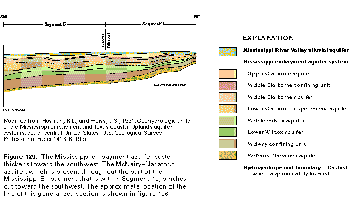
Extensive and massive beds of sand characterize the Mississippi embayment aquifer system. These beds thin and pinch out along the updip limit of the Mississippi Embayment. Aquifers in the Mississippi embayment aquifer system thicken toward the center of the embayment (fig. 128) and toward the southwest parallel to the axis of the embayment (fig. 129). Although the McNairy-Nacatoch aquifer is present throughout the part of the Mississippi Embayment that is within Segment 10, it pinches out toward the southwest. The Mississippi embayment aquifer system overlies consolidated sedimentary rocks of Paleozoic age or clay and chalk of Cretaceous age that are much less permeable than the sediments of the aquifer system.
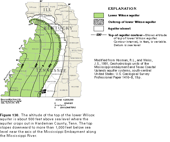
The tops of the aquifers in Tertiary and Cretaceous rocks slope toward the axis of the Mississippi Embayment; for example, the top of the lower Wilcox aquifer (fig. 130) is at an altitude of about 300 feet along much of the area where the aquifer crops out. Near the center of the Mississippi Embayment, however, the top of the aquifer is more than 1,000 feet below sea level. The troughlike configuration of the aquifers generally is more evident for the deeper aquifers than for the shallower ones (fig. 128).
Mississippi River Valley Alluvial Aquifer
The Mississippi River Valley alluvial aquifer is present only along the Mississippi River in Segment 10. The alluvial aquifer consists primarily of Quaternary sediments that range from clay to coarse gravel. The sediments commonly grade downward from fine sand, silt, or clay at the top to coarse sand or gravel at the base. These sediments reach a maximum thickness of about 100 feet and have a total thickness of sand and gravel of about 80 feet in northwestern Tennessee and western Kentucky.
The Mississippi River Valley alluvial aquifer is capable of sustaining well yields of several thousand gallons per minute because it is hydraulically connected to the Mississippi River. Thus, recharge may be induced from the river to the aquifer in places where pumping wells located near the river have lowered the water level in the aquifer below that of the river. However, this aquifer is not a major source of ground water in Segment 10 because of its small areal extent. Where the alluvial aquifer covers aquifers in Tertiary rocks, there is direct hydraulic connection between the alluvial aquifer and the underlying aquifers.
MISSISSIPPI EMBAYMENT AQUIFER SYSTEM
Upper Claiborne Aquifer
The upper Claiborne aquifer is the uppermost hydrogeo-logic unit of the Mississippi embayment aquifer system. Locally, it is overlain by the Mississippi River Valley alluvial aquifer. Sand of the Cockfield Formation is the most productive part of the upper Claiborne aquifer; locally, sand of the Jackson Formation also is productive (fig. 127). The upper Claiborne aquifer thickens to more than 400 feet in parts of Lauderdale and Tip-ton Counties, Tenn. (fig. 131). The aquifer thins updip toward outcrop areas and downdip toward the southwest as the sand that composes the aquifer gradually grades into clay.
The upper Claiborne aquifer consists of interbedded fine sand, silt, clay, and some lignite; thicker sand beds are common near the base of the aquifer. Sands of this aquifer are the result of fluvial deposition from a number of sources and tend to be of limited areal extent. Therefore, the aquifer provides only small supplies of ground water in Segment 10. Hydraulic connection between the sands is better in updip areas where intervening clay layers are thinner than in downdip areas. Thick clay beds of the Cook Mountain Formation (fig. 127) underlie the upper Claiborne aquifer everywhere and retard the downward movement of ground water from the upper Claiborne aquifer to deeper aquifers.
Middle Claiborne Aquifer
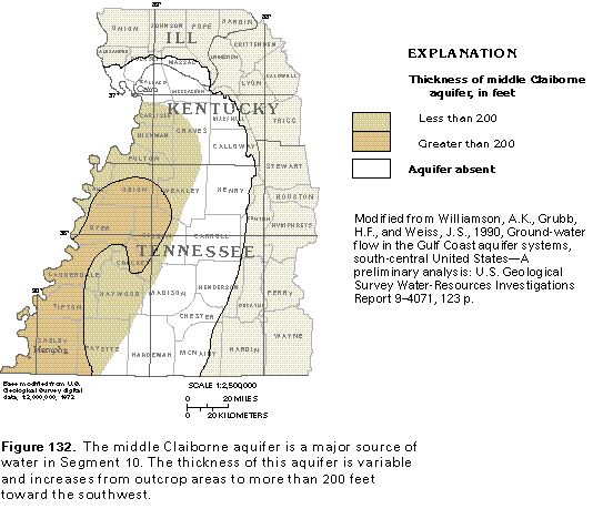
The middle Claiborne aquifer is a major source of ground water in the Mississippi embayment aquifer system in Segment 10. This aquifer primarily consists of the Sparta Sand in Kentucky (fig. 127) and the upper part of the Memphis Sand in Tennessee. The lower part of the Memphis Sand is considered to be part of the regional lower Claiborne-upper Wilcox aquifer. The middle Claiborne aquifer includes sands of the Tallahatta Formation in Kentucky.
The thickness of the middle Claiborne aquifer is variable (fig. 132). Sands of the middle Claiborne aquifer are derived from continental sources and are thick and massive with few or no clay layers. Therefore, these sands are hydraulically well connected, which allows large quantities of water to be withdrawn from the aquifer.
The middle Claiborne aquifer is in direct hydraulic connection with the underlying lower Claiborne-upper Wilcox aquifer in Tennessee and Kentucky. No confining unit separates the aquifers in these States. Farther downdip, however, an effective confining unit called the lower Claiborne confining unit retards the vertical movement of the water between these two aquifers. Because the lower Claiborne confining unit is extensive in Segment 5, it is discussed in more detail in the Atlas Chapter which describes that segment.
Lower Claiborne-Upper Wilcox Aquifer
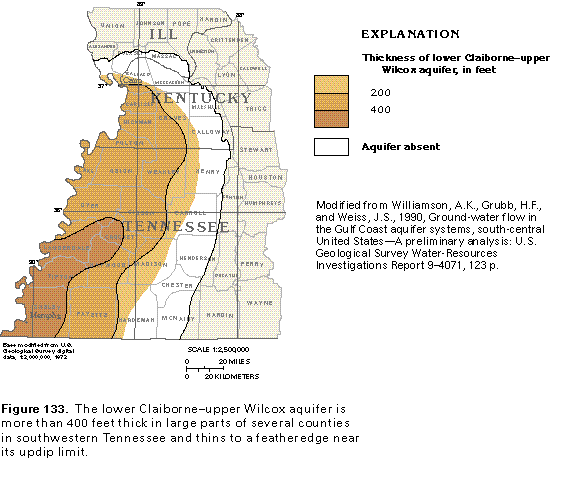
The lower Claiborne-upper Wilcox aquifer in Illinois and Kentucky consists of the upper part of the Wilcox Formation (fig. 127). In Tennessee, the aquifer consists of the lower part of the Memphis Sand. The Flour Island Formation in Tennessee is consists of silt and clay and forms a local confining unit that separates the lower Claiborne-upper Wilcox aquifer from the underlying middle Wilcox aquifer. The lower Claiborne-upper Wilcox aquifer is directly overlain by and is hydraulically connected to the middle Claiborne aquifer in Kentucky and Tennessee and the Mississippi River Valley alluvial aquifer in Illinois.
The lower Claiborne-upper Wilcox aquifer thickens from a featheredge at its updip limit to more than 400 feet in southwestern Tennessee (fig. 133). The aquifer consists of thick beds of fine to coarse sand interbedded with thin layers of lignite, clay, and silt. The lower Claiborne-upper Wilcox aquifer, coupled with the overlying middle Claiborne aquifer, are known as the Memphis Sand in southwestern Tennessee. The Memphis Sand is the primary source of water supply for the city of Memphis and much of westernmost Tennessee.
Middle Wilcox Aquifer
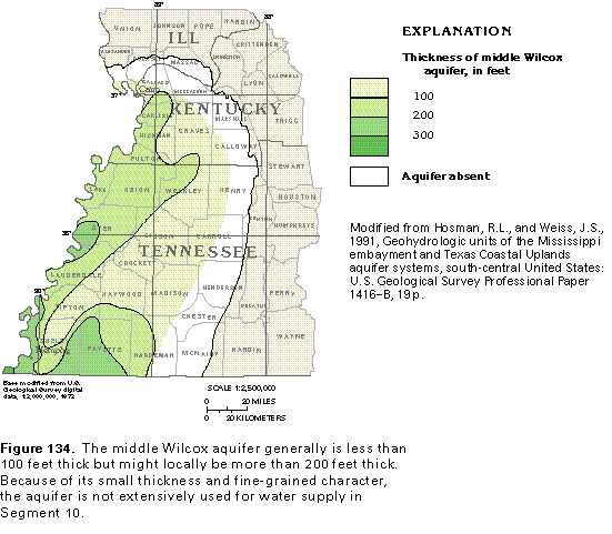
The middle Wilcox aquifer primarily consists of the Wilcox Formation in Illinois and Kentucky and the Fort Pillow Sand in Tennessee (fig. 127). The aquifer is thin, generally less than 200 feet thick (fig. 134). Locally, near the Mississippi River and the Tennessee-Mississippi State line, the aquifer is more than 200 feet thick.
Sediments of continental origin, which compose the middle Wilcox aquifer, consist of thin, interbedded, fine sand, silt, and clay, all with low permeability. Sand beds of the middle Wilcox aquifer typically are thin and discontinuous, but thick sand beds of limited areal extent may occur locally. Fine sands and interbedded clays within the aquifer offer resistance to the vertical flow of water. Where present, the Flour Island Formation is a confining unit between the middle Wilcox aquifer and overlying aquifers. The middle Wilcox aquifer generally is not used as a source of ground water because the sand beds are thin and discontinuous. However, dug wells in the outcrop area of the aquifer, especially those wells that penetrate thick sand beds, provide ground water for domestic supplies in some areas.
Lower Wilcox Aquifer
The lower Wilcox aquifer directly underlies the middle Wilcox aquifer and is the lowermost aquifer in Tertiary rocks in the Mississippi embayment aquifer system. This aquifer consists of part of the Wilcox Formation in Illinois and Kentucky and the Old Breastworks Formation in Tennessee (fig. 127). Some of the sands included in the lower Wilcox aquifer are referred to locally as the "1400-foot" sand in the Memphis area.
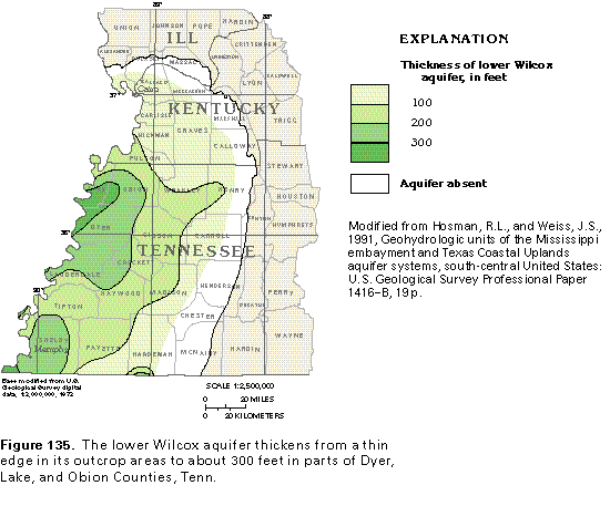
The thickness of the lower Wilcox aquifer increases from a featheredge at the eastern limit of its outcrop to a maximum of more than 300 feet in parts of Dyer, Lake, and Obion Counties in Tennessee (fig. 135). Total sand thickness in the aquifer also is greatest in this area.
The lower Wilcox aquifer consists of sands deposited in fluvial conditions similar to those in the floodplain of the present-day Mississippi River. These sands are hydraulically connected to each other laterally and, to a lesser degree, vertically. The lower Wilcox aquifer is a sandy facies in the lower part of the Wilcox Formation.
The lower Wilcox aquifer is underlain by a thick sequence of marine clay beds known as the Midway confining unit (fig. 127). This confining unit hydraulically separates the lower Wilcox aquifer from underlying aquifers in Cretaceous rocks, except locally where the confining unit is thin.
McNairy-Nacatoch Aquifer
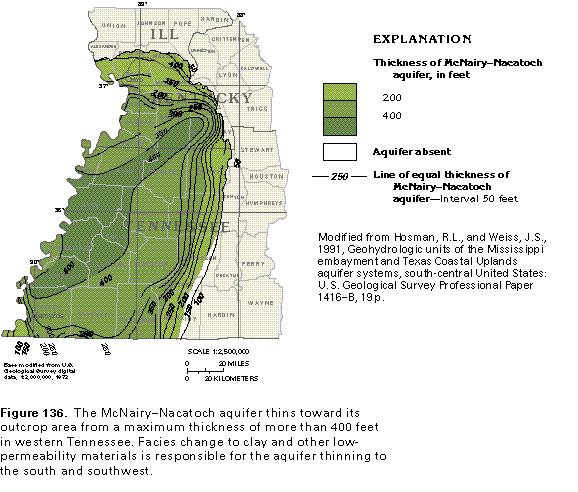
The McNairy-Nacatoch aquifer is in Upper Cretaceous rocks and is the lowermost hydrogeologic unit included in the Mississippi embayment aquifer system (fig. 127). The Mc-Nairy-Nacatoch aquifer is included in the aquifer system because of the local hydraulic connection between this aquifer and the overlying aquifers in Tertiary rocks in the northern part of the Mississippi Embayment where the Midway confining unit is thin. However, the McNairy-Nacatoch aquifer appears to be hydraulically separated from the overlying aquifers throughout most of the Mississippi Embayment. The McNairy-Nacatoch aquifer primarily consists of the McNairy Sand in Segment 10 but also includes the Nacatoch Sand. Other underlying sands of Late Cretaceous age, including the Coffee Sand and sand beds in the Demopolis, the Eutaw, and the Tuscaloosa Formations, are discontinuous in Segment 10. The McNairy-Nacatoch aquifer thickens from less than 50 feet near its updip limit to a maximum of more than 400 feet (fig. 136). Sand in the McNairy-Nacatoch aquifer is present as a single thick bed or as two or more thick sand beds separated by thin clay or marl layers. The sand facies locally is overlain by clay and marl of Late Cretaceous age, which, in turn, are overlain by clays of the Midway confining unit. The clean, fine sands change laterally to clay, marl, and limestone toward the southwest and are accompanied by calcareous cementation that fills the pore space between sand grains and greatly reduces the permeability of the sand. This abrupt facies change is in Mississippi, south of Segment 10.
Ground-Water Movement
The principal aquifers in the Mississippi embayment aquifer system that are used for water supply in Segment 10 are the middle Claiborne, the lower Wilcox, and the McNairy-Nacatoch aquifers. The middle Claiborne and the lower Wilcox aquifers are recharged by precipitation on aquifer outcrop areas and by downward leakage from overlying aquifers. Because the outcrop area of the lower Wilcox aquifer is small, the primary source of recharge to this aquifer is downward leakage. Most recharge to the McNairy-Nacatoch aquifer is from precipitation on outcrop areas; a small quantity of recharge is by upward leakage from underlying aquifers. Discharge from all aquifers in the system is mainly to streams in outcrop areas or to the Mississippi River Valley alluvial aquifer where the alluvial aquifer is present; some discharge is to wells. In the deeper, confined parts of the aquifers, upward leakage to shallower aquifers occurs.
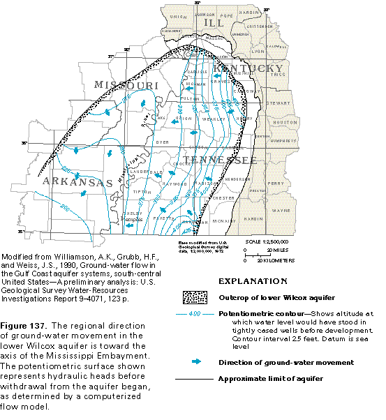
Regional ground-water movement in the aquifers of the Mississippi embayment aquifer system generally is from aquifer outcrop areas toward the axis of the Mississippi Embayment. The potentiometric surface of the lower Wilcox aquifer (fig. 137) is representative of the configuration of hydraulic heads in these aquifers. Water enters the aquifers at the updip, higher altitude outcrop areas and moves down the dip of the aquifers. In the example shown in figure 137, water also enters the lower Wilcox aquifer in subcrop areas in Missouri and Arkansas by downward leakage from shallower aquifers. The general direction of movement of the water is toward the Mississippi River and subsequently to the southwest along the axis of the Mississippi Embayment. Ultimately, the water discharges by upward leakage to shallower aquifers in downdip areas.
HYDRAULIC CHARACTERISTICS OF PRINCIPAL AQUIFERS
Yields from the Mississippi embayment aquifer system in Segment 10 tend to be greater for wells completed in the aquifers in Tertiary rocks than for those completed in the McNairy-Nacatoch aquifer. In Tennessee, wells completed in the middle Claiborne and the lower Wilcox aquifers commonly yield from 200 to 1,000 gallons per minute, but yields might locally exceed 2,000 gallons per minute. Wells completed in the McNairy-Nacatoch aquifer commonly yield from 50 to 500 gallons per minute, but yields might exceed 1,000 gallons per minute. Yields for wells completed in these aquifers in Kentucky are smaller. Wells completed in the middle Claiborne and the lower Wilcox aquifers in Kentucky yield from 5 to 100 gallons per minute, and wells completed in the McNairy-Nactoch aquifer in Kentucky yield from 5 to 25 gallons per minute.
Transmissivity is a measure of the ease with which water can move through an aquifer. The larger the transmissivity, the more readily water can move through the aquifer. The middle Claiborne aquifer in Segment 10 has an average transmissivity of about 29,000 feet squared per day, as indicated by 80 aquifer tests. The lower Wilcox aquifer in this segment has an average transmissivity of about 13,000 feet squared per day, as indicated by 24 aquifer tests. The McNairy-Nactoch aquifer has an average transmissivity of about 4,000 feet squared per day, as indicated by two aquifer tests.
GROUND-WATER QUALITY
The chemical quality of water from the aquifers in the Mississippi embayment aquifer system generally is suitable for most uses. The areal distribution of constituents in the water differs within individual aquifers, as well as between aquifers. Water in these aquifers is soft to moderately hard and is usually a calcium bicarbonate type in aquifer outcrop areas. As the water moves deeper into the aquifers, it becomes a sodium bicarbonate type. Iron, fluoride, and sulfate concentrations typically are small in water from all the aquifers.
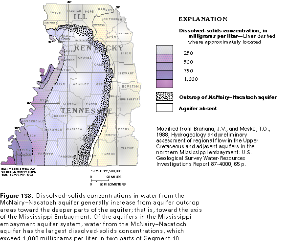
Dissolved-solids concentrations usually are less than 250 milligrams per liter in water from most of the aquifers in the Mississippi embayment aquifer system. However, dissolved-solids concentrations increase as the water moves along flow paths into deeper parts of the aquifers. A map of dissolved-solids concentrations in water from the McNairy-Nacatoch aquifer (fig. 138) shows such an increase. Locally, dissolved-solids concentrations in water from this aquifer exceed 1,000 milligrams per liter.
FRESH GROUND-WATER WITHDRAWALS
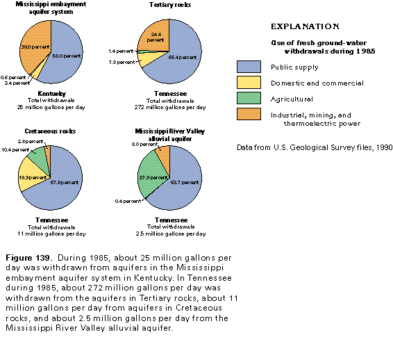
Total ground-water withdrawals from the aquifers of the Mississippi embayment aquifer system in Kentucky and Tennessee were about 311 million gallons per day during 1985. Most of this water, about 272 million gallons per day, or about 87 percent of the total, was withdrawn from aquifers in the Tertiary rocks in Tennessee (fig. 139). The Memphis, Tenn., area, which is totally supplied by ground water, accounted for withdrawals of about 196 million gallons per day. In comparison, only about 11 million gallons per day was withdrawn from the aquifers in Cretaceous rocks in Tennessee, and about 25 million gallons per day was withdrawn from the entire aquifer sys-tem in Kentucky. In Kentucky, about 70 percent of this water was supplied by aquifers in Tertiary rocks and about 30 percent by aquifers in Cretaceous rocks. About 2.5 million gallons per day was withdrawn from the Mississippi River Valley alluvial aquifer in Tennessee during 1985.
Ground water is the major source of water for public supply throughout the Coastal Plain Province in Segment 10. During 1985, withdrawals for public supply and for industrial, commercial, and thermoelectric power uses accounted for more than 90 percent of the ground water withdrawn from the aquifers in Tertiary and Cretaceous rocks in Kentucky and the aquifers in Tertiary rocks in Tennessee. Public-supply withdrawals accounted for about 65 to 70 percent of the water withdrawn from all the aquifers in the Mississippi embayment aquifer system in Tennessee.
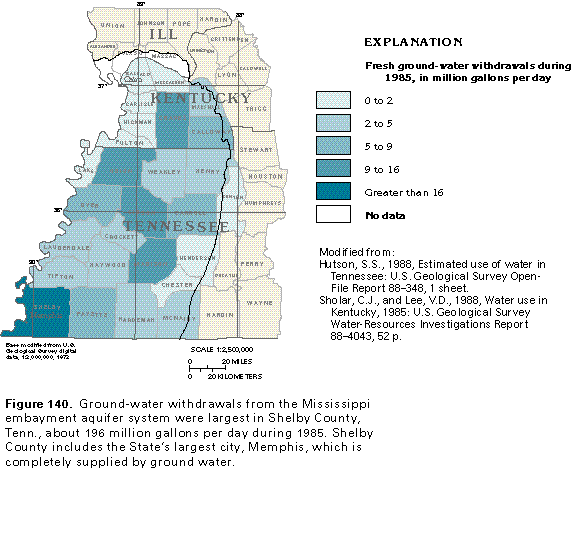
Shelby County, Tenn., which includes the city of Memphis, withdrew about 196 million gallons per day of freshwater during 1985. As shown in figure 140, withdrawals in other counties in the Coastal Plain Province in Segment 10 were much smaller.