GROUND WATER ATLAS of the UNITED STATES
Illinois, Indiana, Kentucky, Ohio, Tennessee
HA 730-K
Blue Ridge, Ozark Plateaus, and Southeastern Coastal Plain aquifers
There are two different files for each illustration
- A 72 ppi GIF file, suitable for screen viewing is accessed through
the thumbnail image
- An eps file, suitable for downloading to be printed or edited is accessed
through the "eps file" link. Most files are Adobe Illustrator
6.0, exceptions are noted. These files have been compressed with GNU's
gzip utility. If your web browser defaults to a screen display of the file,
turn on the "Load to local disk" option before downloading. Download
and process these eps files as ascii, not binary.
Blue Ridge aquifers
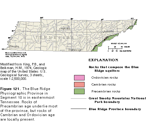
Figure 121 Map of rocks that compose the Blue Ridge aquifers (17K)
 editable eps file k121.eps.gz
(50K compressed)
editable eps file k121.eps.gz
(50K compressed)
Ground-water occurrence
Figure 122 Cross section showing ground-water movement (17K)
 editable eps file k122.eps.gz
(33K compressed)
editable eps file k122.eps.gz
(33K compressed)
Ground-water quality
Figure 123 Water quality chart for Cambrian and Precambrian sandstones
in Tennessee (17K)
 editable eps file k123.eps.gz
(17K compressed)
editable eps file k123.eps.gz
(17K compressed)
 editable eps file k121.eps.gz
(50K compressed)
editable eps file k121.eps.gz
(50K compressed) 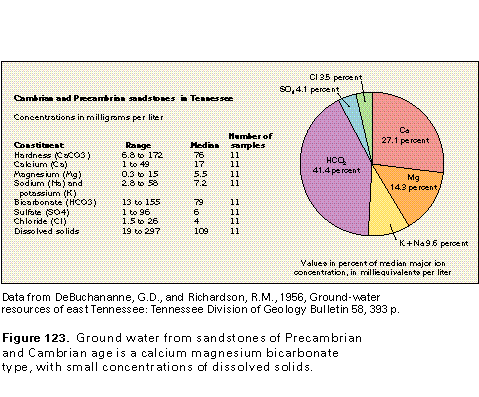 editable eps file k123.eps.gz
(17K compressed)
editable eps file k123.eps.gz
(17K compressed)